Dompierre-sur-Veyle
Dompierre-sur-Veyle is a commune in the Ain department in eastern France.
Dompierre-sur-Veyle | |
|---|---|
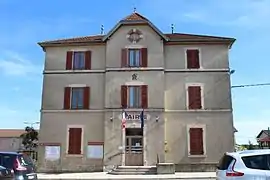 The town hall in Dompierre-sur-Veyle | |
Location of Dompierre-sur-Veyle 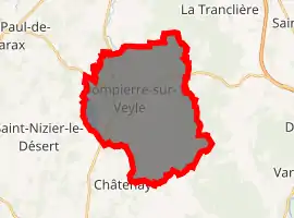
| |
 Dompierre-sur-Veyle  Dompierre-sur-Veyle | |
| Coordinates: 46°04′00″N 5°12′00″E | |
| Country | France |
| Region | Auvergne-Rhône-Alpes |
| Department | Ain |
| Arrondissement | Bourg-en-Bresse |
| Canton | Ceyzériat |
| Intercommunality | CA Bassin de Bourg-en-Bresse |
| Government | |
| • Mayor (2008–2014) | Jean Bérard |
| Area 1 | 29.10 km2 (11.24 sq mi) |
| Population (2017-01-01)[1] | 1,166 |
| • Density | 40/km2 (100/sq mi) |
| Time zone | UTC+01:00 (CET) |
| • Summer (DST) | UTC+02:00 (CEST) |
| INSEE/Postal code | 01145 /01240 |
| Elevation | 264–312 m (866–1,024 ft) (avg. 285 m or 935 ft) |
| 1 French Land Register data, which excludes lakes, ponds, glaciers > 1 km2 (0.386 sq mi or 247 acres) and river estuaries. | |
Geography
The Veyle forms part of the commune's southwestern border, then flows north through the middle of the commune.
Population
| Year | Pop. | ±% |
|---|---|---|
| 1793 | 837 | — |
| 1800 | 618 | −26.2% |
| 1806 | 685 | +10.8% |
| 1821 | 727 | +6.1% |
| 1831 | 746 | +2.6% |
| 1836 | 780 | +4.6% |
| 1841 | 893 | +14.5% |
| 1846 | 986 | +10.4% |
| 1851 | 928 | −5.9% |
| 1856 | 1,013 | +9.2% |
| 1861 | 989 | −2.4% |
| 1866 | 1,054 | +6.6% |
| 1872 | 1,084 | +2.8% |
| 1876 | 1,105 | +1.9% |
| 1881 | 1,132 | +2.4% |
| 1886 | 1,174 | +3.7% |
| 1891 | 1,160 | −1.2% |
| 1896 | 1,098 | −5.3% |
| 1901 | 1,080 | −1.6% |
| 1906 | 1,098 | +1.7% |
| 1911 | 1,065 | −3.0% |
| 1921 | 910 | −14.6% |
| 1926 | 877 | −3.6% |
| 1931 | 811 | −7.5% |
| 1936 | 834 | +2.8% |
| 1946 | 756 | −9.4% |
| 1954 | 702 | −7.1% |
| 1962 | 705 | +0.4% |
| 1968 | 662 | −6.1% |
| 1975 | 632 | −4.5% |
| 1982 | 745 | +17.9% |
| 1990 | 828 | +11.1% |
| 1999 | 968 | +16.9% |
| 2008 | 1,198 | +23.8% |
See also
References
- "Populations légales 2017". INSEE. Retrieved 6 January 2020.
| Wikimedia Commons has media related to Dompierre-sur-Veyle. |
This article is issued from Wikipedia. The text is licensed under Creative Commons - Attribution - Sharealike. Additional terms may apply for the media files.