Châtillon-sur-Chalaronne
Châtillon-sur-Chalaronne is a commune in the Ain department in eastern France.
Châtillon-sur-Chalaronne | |
|---|---|
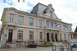 The town hall in Châtillon-sur-Chalaronne | |
.svg.png.webp) Coat of arms | |
Location of Châtillon-sur-Chalaronne 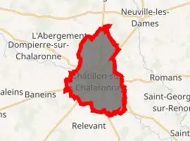
| |
 Châtillon-sur-Chalaronne  Châtillon-sur-Chalaronne | |
| Coordinates: 46°07′00″N 4°58′00″E | |
| Country | France |
| Region | Auvergne-Rhône-Alpes |
| Department | Ain |
| Arrondissement | Bourg-en-Bresse |
| Canton | Châtillon-sur-Chalaronne |
| Intercommunality | Dombes |
| Government | |
| • Mayor (2020–2026) | Patrick Mathias |
| Area 1 | 17.86 km2 (6.90 sq mi) |
| Population (2017-01-01)[1] | 4,859 |
| • Density | 270/km2 (700/sq mi) |
| Time zone | UTC+01:00 (CET) |
| • Summer (DST) | UTC+02:00 (CEST) |
| INSEE/Postal code | 01093 /01400 |
| Elevation | 215–274 m (705–899 ft) (avg. 225 m or 738 ft) |
| 1 French Land Register data, which excludes lakes, ponds, glaciers > 1 km2 (0.386 sq mi or 247 acres) and river estuaries. | |
History
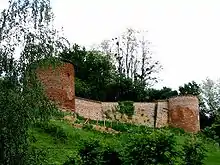
Châtillon castle fortifications
The town has a castle built around 1000 AD.
The town was formerly named Châtillon-les-Dombes.
Geography
The Chalaronne flows northwest through the commune and crosses the town.
Population
| Year | Pop. | ±% |
|---|---|---|
| 2006 | 4,813 | — |
| 2007 | 4,904 | +1.9% |
| 2008 | 4,924 | +0.4% |
| 2009 | 4,899 | −0.5% |
| 2010 | 4,922 | +0.5% |
| 2011 | 4,940 | +0.4% |
| 2012 | 4,957 | +0.3% |
| 2013 | 4,957 | +0.0% |
| 2014 | 4,956 | −0.0% |
| 2015 | 4,914 | −0.8% |
| 2016 | 4,886 | −0.6% |
Twin towns
- Wächtersbach (Germany)
- Colceag (Romania)
Notable people
- Saint Vincent de Paul: was curate of Châtillon and founded the Brotherhood of Charity (1617)
- Philibert Commerson: botanist, born in Châtillon in 1727
Church 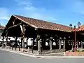
Historic market hall 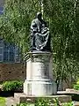
Monument Vincent de Paul
See also
References
- "Populations légales 2017". INSEE. Retrieved 6 January 2020.
External links
| Wikimedia Commons has media related to Châtillon-sur-Chalaronne. |
- Châtillon-sur-Chalaronne official website
- La Dombes and Châtillon-sur-Chalaronne
- Images by Paul C. Maurice
| Authority control |
|---|
This article is issued from Wikipedia. The text is licensed under Creative Commons - Attribution - Sharealike. Additional terms may apply for the media files.