Saint-André-le-Bouchoux
Saint-André-le-Bouchoux is a commune in the Ain department in eastern France.
Saint-André-le-Bouchoux | |
|---|---|
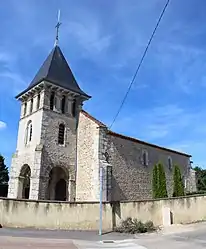 The church in Saint-André-le-Bouchoux | |
Location of Saint-André-le-Bouchoux 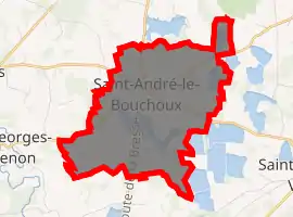
| |
 Saint-André-le-Bouchoux  Saint-André-le-Bouchoux | |
| Coordinates: 46°07′00″N 5°05′00″E | |
| Country | France |
| Region | Auvergne-Rhône-Alpes |
| Department | Ain |
| Arrondissement | Bourg-en-Bresse |
| Canton | Châtillon-sur-Chalaronne |
| Intercommunality | Chalaronne-centre |
| Government | |
| • Mayor (2008–2014) | Alain Jayr |
| Area 1 | 9.5 km2 (3.7 sq mi) |
| Population (2017-01-01)[1] | 390 |
| • Density | 41/km2 (110/sq mi) |
| Time zone | UTC+01:00 (CET) |
| • Summer (DST) | UTC+02:00 (CEST) |
| INSEE/Postal code | 01335 /01240 |
| Elevation | 259–274 m (850–899 ft) (avg. 268 m or 879 ft) |
| 1 French Land Register data, which excludes lakes, ponds, glaciers > 1 km2 (0.386 sq mi or 247 acres) and river estuaries. | |
The river Irance, at tributary of the lake Grand Romans, runs through the town.
In 1836, the community was considered one of the poorest in France. It has gained wealth since, though. Today, most of the town revolves around restaurants, farms, and crafts.
Population
|
|
Sights
Its most historic monument is the church, designed in the Roman style in the 11th century and redesigned in the 15th.
See also
References
- "Populations légales 2017". INSEE. Retrieved 6 January 2020.
External links
| Wikimedia Commons has media related to Saint-André-le-Bouchoux. |
This article is issued from Wikipedia. The text is licensed under Creative Commons - Attribution - Sharealike. Additional terms may apply for the media files.