Brégnier-Cordon
Brégnier-Cordon is a commune in the Ain department in eastern France.
Brégnier-Cordon | |
|---|---|
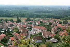 A general view of Brégnier | |
Location of Brégnier-Cordon 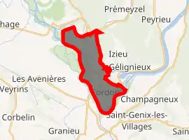
| |
 Brégnier-Cordon  Brégnier-Cordon | |
| Coordinates: 45°39′00″N 5°37′00″E | |
| Country | France |
| Region | Auvergne-Rhône-Alpes |
| Department | Ain |
| Arrondissement | Belley |
| Canton | Belley |
| Intercommunality | Bugey Sud |
| Government | |
| • Mayor (2020–2026) | Thierry Vergain |
| Area 1 | 11.05 km2 (4.27 sq mi) |
| Population (2017-01-01)[1] | 839 |
| • Density | 76/km2 (200/sq mi) |
| Time zone | UTC+01:00 (CET) |
| • Summer (DST) | UTC+02:00 (CEST) |
| INSEE/Postal code | 01058 /01300 |
| Elevation | 203–460 m (666–1,509 ft) (avg. 226 m or 741 ft) |
| 1 French Land Register data, which excludes lakes, ponds, glaciers > 1 km2 (0.386 sq mi or 247 acres) and river estuaries. | |
Geography
Brégnier-Cordon lies 20 km south of Belley. It is located in a bend of the Rhône on the edge of Savoie (on the southeast) and Isère (on the west). The bridge at Cordon joins the commune to Aoste, in the Isère department. It borders the communes of Groslée-Saint-Benoît, Prémeyzel, Izieu, Murs-et-Gélignieux, Champagneux, Saint-Genix-les-Villages, Aoste and Les Avenières-Veyrins-Thuellin.
The territory of the commune lies principally in the plain of the Rhône at the foot of the Jura mountains. On the north, it is bordered by the Gland.
The Lake of Glandieu is located in the commune near the hamlet of the same name.
Population
| Year | Pop. | ±% |
|---|---|---|
| 2005 | 659 | — |
| 2006 | 671 | +1.8% |
| 2007 | 699 | +4.2% |
| 2008 | 746 | +6.7% |
| 2009 | 789 | +5.8% |
| 2010 | 832 | +5.4% |
| 2011 | 862 | +3.6% |
| 2012 | 889 | +3.1% |
| 2013 | 865 | −2.7% |
| 2014 | 861 | −0.5% |
| 2015 | 856 | −0.6% |
| 2016 | 849 | −0.8% |
Transportation
The commune is on the D19 highway coming from Sault-Brénaz and going to the northwest. This becomes the D992 south of the commune and heads north toward Belley. The D10 passes north of the commune, connecting the D19 to the D992 without following the Rhône.
The closest motorway is the A43, accessed at the Chimilin–Les Abrets exit a few kilometers south of the commune.
Monuments and sites
- Château de la Barre
- Ruins of the feudal Château de Cordon
- Stone bridge over the Rhône
- Memorial to deported Jewish children
- Dam and hydroelectric power station on the Rhône
- Grotte de Liévrin : prehistoric cave classified as a monument historique in 1913
- Grotte de la Bonne Femme : natural cavity cut into the north flank of Cordon hill, occupied in paleolithic times and a monument historique since 1913
- Cascade de Glandieu : waterfall

See also
References
- "Populations légales 2017". INSEE. Retrieved 6 January 2020.
| Wikimedia Commons has media related to Brégnier-Cordon. |