Saint-Denis-en-Bugey
Saint-Denis-en-Bugey is a commune in the Ain department in eastern France.
Saint-Denis-en-Bugey | |
|---|---|
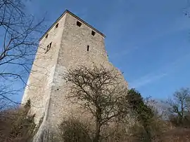 The chateau in Saint-Denis-en-Bugey | |
.svg.png.webp) Coat of arms | |
Location of Saint-Denis-en-Bugey 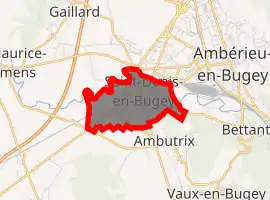
| |
 Saint-Denis-en-Bugey  Saint-Denis-en-Bugey | |
| Coordinates: 45°57′00″N 5°20′00″E | |
| Country | France |
| Region | Auvergne-Rhône-Alpes |
| Department | Ain |
| Arrondissement | Belley |
| Canton | Ambérieu-en-Bugey |
| Intercommunality | Plaine de l'Ain |
| Government | |
| • Mayor (2008–2014) | Bernard Servais |
| Area 1 | 2.61 km2 (1.01 sq mi) |
| Population (2017-01-01)[1] | 2,309 |
| • Density | 880/km2 (2,300/sq mi) |
| Time zone | UTC+01:00 (CET) |
| • Summer (DST) | UTC+02:00 (CEST) |
| INSEE/Postal code | 01345 /01500 |
| Elevation | 234–338 m (768–1,109 ft) (avg. 250 m or 820 ft) |
| 1 French Land Register data, which excludes lakes, ponds, glaciers > 1 km2 (0.386 sq mi or 247 acres) and river estuaries. | |
Geography
The town lies on the left bank of the river Albarine, which forms all of the commune's northern border.
Population
|
|
See also
References
- "Populations légales 2017". INSEE. Retrieved 6 January 2020.
| Wikimedia Commons has media related to Saint-Denis-en-Bugey. |
This article is issued from Wikipedia. The text is licensed under Creative Commons - Attribution - Sharealike. Additional terms may apply for the media files.