Nivollet-Montgriffon
Nivollet-Montgriffon is a commune in the Ain department in eastern France.
Nivollet-Montgriffon | |
|---|---|
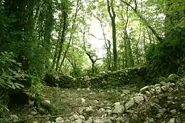 Ruins of the chateau | |
Location of Nivollet-Montgriffon 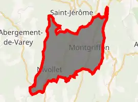
| |
 Nivollet-Montgriffon  Nivollet-Montgriffon | |
| Coordinates: 45°59′00″N 5°26′00″E | |
| Country | France |
| Region | Auvergne-Rhône-Alpes |
| Department | Ain |
| Arrondissement | Belley |
| Canton | Ambérieu-en-Bugey |
| Government | |
| • Mayor (2008–2014) | Jean-Claude Lherbe |
| Area 1 | 8.24 km2 (3.18 sq mi) |
| Population | 119 |
| • Density | 14/km2 (37/sq mi) |
| Time zone | UTC+01:00 (CET) |
| • Summer (DST) | UTC+02:00 (CEST) |
| INSEE/Postal code | 01277 /01230 |
| Elevation | 440–833 m (1,444–2,733 ft) (avg. 598 m or 1,962 ft) |
| 1 French Land Register data, which excludes lakes, ponds, glaciers > 1 km2 (0.386 sq mi or 247 acres) and river estuaries. | |
Population
|
|
See also
References
- "Populations légales 2017". INSEE. Retrieved 6 January 2020.
| Wikimedia Commons has media related to Nivollet-Montgriffon. |
This article is issued from Wikipedia. The text is licensed under Creative Commons - Attribution - Sharealike. Additional terms may apply for the media files.