Salavre
Salavre is a commune in the Ain department in eastern France.
Salavre | |
|---|---|
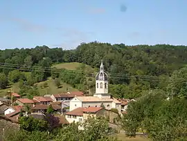 A general view of Salavre | |
Location of Salavre 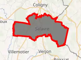
| |
 Salavre  Salavre | |
| Coordinates: 46°21′50″N 5°20′46″E | |
| Country | France |
| Region | Auvergne-Rhône-Alpes |
| Department | Ain |
| Arrondissement | Bourg-en-Bresse |
| Canton | Saint-Étienne-du-Bois |
| Intercommunality | CA Bassin de Bourg-en-Bresse |
| Government | |
| • Mayor (2008–2014) | Gérard Poupon |
| Area 1 | 7.77 km2 (3.00 sq mi) |
| Population (2017-01-01)[1] | 272 |
| • Density | 35/km2 (91/sq mi) |
| Time zone | UTC+01:00 (CET) |
| • Summer (DST) | UTC+02:00 (CEST) |
| INSEE/Postal code | 01391 /01270 |
| Elevation | 203–561 m (666–1,841 ft) (avg. 318 m or 1,043 ft) |
| 1 French Land Register data, which excludes lakes, ponds, glaciers > 1 km2 (0.386 sq mi or 247 acres) and river estuaries. | |
Geography
It is located around 15 km (9.3 mi) north of Bourg-en-Bresse and 40 km (25 mi) south of Lons-le-Saunier. The village lies on a small river, known as le Bief Laval, a tributary of the Solnan.
The Solnan forms part of the commune's western border.
Population
|
|
See also
References
- "Populations légales 2017". INSEE. Retrieved 6 January 2020.
| Wikimedia Commons has media related to Salavre. |
This article is issued from Wikipedia. The text is licensed under Creative Commons - Attribution - Sharealike. Additional terms may apply for the media files.