Birieux
Birieux is a commune in the Ain department in eastern France.
Birieux | |
|---|---|
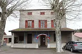 The town hall in Birieux | |
 Coat of arms | |
Location of Birieux 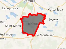
| |
 Birieux  Birieux | |
| Coordinates: 45°57′12″N 5°02′23″E | |
| Country | France |
| Region | Auvergne-Rhône-Alpes |
| Department | Ain |
| Arrondissement | Bourg-en-Bresse |
| Canton | Villars-les-Dombes |
| Intercommunality | Dombes |
| Government | |
| • Mayor (2014-2020) | François Christolhomme |
| Area 1 | 15.83 km2 (6.11 sq mi) |
| Population (2017-01-01)[1] | 283 |
| • Density | 18/km2 (46/sq mi) |
| Time zone | UTC+01:00 (CET) |
| • Summer (DST) | UTC+02:00 (CEST) |
| INSEE/Postal code | 01045 /01330 |
| Elevation | 277–295 m (909–968 ft) (avg. 285 m or 935 ft) |
| 1 French Land Register data, which excludes lakes, ponds, glaciers > 1 km2 (0.386 sq mi or 247 acres) and river estuaries. | |
Geography
The Chalaronne forms part of the commune's northwestern border.
History
Birieux is first mentioned in the 12th century as a priory dependent on the abbey of l'Île Barbe à Lyon.
In the Middle Ages, Birieux was a possession of the lords of Thoire-Villars.
In 1789, the commune was included in the canton of Meximieux.
Population
| Year | Pop. | ±% |
|---|---|---|
| 2006 | 211 | — |
| 2007 | 221 | +4.7% |
| 2008 | 230 | +4.1% |
| 2009 | 225 | −2.2% |
| 2010 | 236 | +4.9% |
| 2011 | 251 | +6.4% |
| 2012 | 265 | +5.6% |
| 2013 | 280 | +5.7% |
| 2014 | 285 | +1.8% |
| 2015 | 287 | +0.7% |
| 2016 | 285 | −0.7% |
Economy
The region is primarily agricultural, producing grain and cattle.
See also
References
- "Populations légales 2017". INSEE. Retrieved 6 January 2020.
External links
| Wikimedia Commons has media related to Birieux. |
This article is issued from Wikipedia. The text is licensed under Creative Commons - Attribution - Sharealike. Additional terms may apply for the media files.
