Saint-Jean-le-Vieux, Ain
Saint-Jean-le-Vieux is a commune in the Ain department in eastern France.
Saint-Jean-le-Vieux | |
|---|---|
_2014-06-28_13.40.57.jpg.webp) The chateau of Varey in Saint-Jean-le-Vieux | |
.svg.png.webp) Coat of arms | |
Location of Saint-Jean-le-Vieux 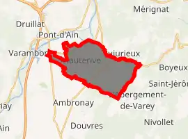
| |
 Saint-Jean-le-Vieux  Saint-Jean-le-Vieux | |
| Coordinates: 46°01′46″N 5°23′24″E | |
| Country | France |
| Region | Auvergne-Rhône-Alpes |
| Department | Ain |
| Arrondissement | Nantua |
| Canton | Pont-d'Ain |
| Intercommunality | Bugey-Vallée de l'Ain |
| Government | |
| • Mayor (2014–2020) | Christian Batailly (PR) |
| Area 1 | 15.2 km2 (5.9 sq mi) |
| Population | 1,723 |
| • Density | 110/km2 (290/sq mi) |
| Time zone | UTC+01:00 (CET) |
| • Summer (DST) | UTC+02:00 (CEST) |
| INSEE/Postal code | 01363 /01640 |
| Elevation | 236–506 m (774–1,660 ft) (avg. 275 m or 902 ft) |
| 1 French Land Register data, which excludes lakes, ponds, glaciers > 1 km2 (0.386 sq mi or 247 acres) and river estuaries. | |
Population
|
|
See also
References
- "Populations légales 2017". INSEE. Retrieved 6 January 2020.
| Wikimedia Commons has media related to Saint-Jean-le-Vieux (Ain). |
This article is issued from Wikipedia. The text is licensed under Creative Commons - Attribution - Sharealike. Additional terms may apply for the media files.