Villemotier
Villemotier is a commune in the Ain department in eastern France.
Villemotier | |
|---|---|
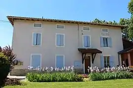 The town hall in Villemotier | |
Location of Villemotier 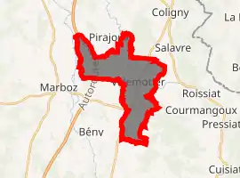
| |
 Villemotier  Villemotier | |
| Coordinates: 46°20′46″N 5°19′16″E | |
| Country | France |
| Region | Auvergne-Rhône-Alpes |
| Department | Ain |
| Arrondissement | Bourg-en-Bresse |
| Canton | Saint-Étienne-du-Bois |
| Intercommunality | CA Bassin de Bourg-en-Bresse |
| Government | |
| • Mayor (2008–2014) | Aimé Girard |
| Area 1 | 13.86 km2 (5.35 sq mi) |
| Population (2017-01-01)[1] | 656 |
| • Density | 47/km2 (120/sq mi) |
| Time zone | UTC+01:00 (CET) |
| • Summer (DST) | UTC+02:00 (CEST) |
| INSEE/Postal code | 01445 /01270 |
| Elevation | 197–261 m (646–856 ft) (avg. 219 m or 719 ft) |
| 1 French Land Register data, which excludes lakes, ponds, glaciers > 1 km2 (0.386 sq mi or 247 acres) and river estuaries. | |
Geography
The Solnan forms parts of the commune's eastern and western borders; it flows southwest through the eastern part of the commune and north through its middle.
Population
|
|
See also
References
- "Populations légales 2017". INSEE. Retrieved 6 January 2020.
| Wikimedia Commons has media related to Villemotier. |
This article is issued from Wikipedia. The text is licensed under Creative Commons - Attribution - Sharealike. Additional terms may apply for the media files.