Saint-Jean-sur-Veyle
Saint-Jean-sur-Veyle is a commune in the Ain department in eastern France.
Saint-Jean-sur-Veyle | |
|---|---|
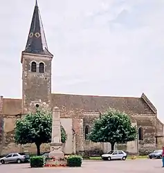 The church in Saint-Jean-sur-Veyle | |
.svg.png.webp) Coat of arms | |
Location of Saint-Jean-sur-Veyle 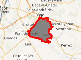
| |
 Saint-Jean-sur-Veyle  Saint-Jean-sur-Veyle | |
| Coordinates: 46°15′32″N 4°54′58″E | |
| Country | France |
| Region | Auvergne-Rhône-Alpes |
| Department | Ain |
| Arrondissement | Bourg-en-Bresse |
| Canton | Vonnas |
| Intercommunality | Veyle |
| Government | |
| • Mayor (2020–2026) | Agnès Renoud-Lyat |
| Area 1 | 11.21 km2 (4.33 sq mi) |
| Population (2017-01-01)[1] | 1,149 |
| • Density | 100/km2 (270/sq mi) |
| Time zone | UTC+01:00 (CET) |
| • Summer (DST) | UTC+02:00 (CEST) |
| INSEE/Postal code | 01365 /01290 |
| Elevation | 176–213 m (577–699 ft) (avg. 183 m or 600 ft) |
| 1 French Land Register data, which excludes lakes, ponds, glaciers > 1 km2 (0.386 sq mi or 247 acres) and river estuaries. | |
Geography
The Veyle flows northwest through the southern part of the commune.
Population
|
|
See also
References
- "Populations légales 2017". INSEE. Retrieved 6 January 2020.
| Wikimedia Commons has media related to Saint-Jean-sur-Veyle. |
This article is issued from Wikipedia. The text is licensed under Creative Commons - Attribution - Sharealike. Additional terms may apply for the media files.