Arbigny
Arbigny is a commune in the Ain department in the Auvergne-Rhône-Alpes region of eastern France.
Arbigny | |
|---|---|
.jpg.webp) The Grand-Étang near Arbigny | |
Location of Arbigny 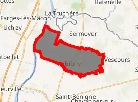
| |
 Arbigny  Arbigny | |
| Coordinates: 46°28′14″N 4°57′48″E | |
| Country | France |
| Region | Auvergne-Rhône-Alpes |
| Department | Ain |
| Arrondissement | Bourg-en-Bresse |
| Canton | Replonges |
| Intercommunality | Bresse et Saône |
| Government | |
| • Mayor (2014-2020) | Daniel Gras |
| Area 1 | 17.47 km2 (6.75 sq mi) |
| Population | 463 |
| • Density | 27/km2 (69/sq mi) |
| Time zone | UTC+01:00 (CET) |
| • Summer (DST) | UTC+02:00 (CEST) |
| INSEE/Postal code | 01016 /01190 |
| Elevation | 169–214 m (554–702 ft) (avg. 200 m or 660 ft) |
| 1 French Land Register data, which excludes lakes, ponds, glaciers > 1 km2 (0.386 sq mi or 247 acres) and river estuaries. | |
The inhabitants of the commune are known as Arbignerons or Arbigneronnes[2]
Geography
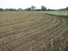
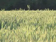
Arbigny is some 20 km north of Mâcon and 40 km south by south-east of Chalon-sur-Saône. The commune can be accessed by the D933 from Sermoyer in the north passing through the centre of the commune and village and continuing south to Pont-de-Vaux. The D126 runs west from the village changing to the D163 at the border of the commune and continuing to Uchizy. There are two other hamlets in the commune - La Croix and La Varenne. About 80% of the commune is farmland with the rest being the forested eastern part.[3]
The western border of the commune is formed by the Saône river. In the north and east there are ponds which are drained by the Biel d'Etang Neuf and the Biel d'Etang Butière which flow west to the Saône.[3]
Neighbouring communes and villages | |
|---|---|
History
The area has been occupied since prehistoric times. The village was known as Albiniacus in the Middle Ages.
Administration
List of mayors of Arbigny[4]
| From | To | Name | Party | Position |
|---|---|---|---|---|
| 1995 | 2008 | Christian Berardet | ||
| 2008 | 2014 | Michel Vieux | ||
| 2014 | Present | Daniel Gras |
(Not all data is known)
Population
| Year | Pop. | ±% |
|---|---|---|
| 2005 | 349 | — |
| 2006 | 349 | +0.0% |
| 2007 | 352 | +0.9% |
| 2008 | 368 | +4.5% |
| 2009 | 383 | +4.1% |
| 2010 | 399 | +4.2% |
| 2011 | 405 | +1.5% |
| 2012 | 414 | +2.2% |
| 2013 | 427 | +3.1% |
| 2014 | 440 | +3.0% |
| 2015 | 453 | +3.0% |
| 2016 | 462 | +2.0% |
Sites and monuments
.jpg.webp)
- The remains of an old Fortified Chateau
- A Napoleonic milestone dated 1808
- A Stone marker commemorating the landing fields of the Royal Air Force during the Second World War, on the road to Uchizy just before the bridge over the Saône. The code name of the landing field was "JUNOT".
- A Plaque honouring two young resistance fighters (Dupasquier and Clairmidi) murdered by the Nazis in 1944 at a place called "La Varenne".
See also
External links
- Arbigny on the old National Geographic Institute website (in French)
- Arbigny on Lion1906
- Arbigny on Géoportail, National Geographic Institute (IGN) website (in French)
- Arbigny on the 1750 Cassini Map
Notes and references
Notes
References
- "Populations légales 2017". INSEE. Retrieved 6 January 2020.
- Inhabitants of Ain (in French)
- Google Maps
- List of Mayors of France (in French)
- Protection Zone for the wetlands of the Saône Valley, Préfectoral directive of 25 February 1994, Préfecture of Ain (in French)
| Wikimedia Commons has media related to Arbigny. |
