Villette-sur-Ain
Villette-sur-Ain is a commune in the Ain department in eastern France. It is located on the banks of the Ain river in the Rhône-Alpes region. Villette-sur-Ain is part of the Dombes and is about 45 km from Lyon.
Villette-sur-Ain | |
|---|---|
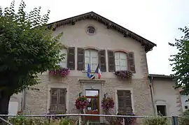 The town hall in Villette-sur-Ain | |
.svg.png.webp) Coat of arms | |
Location of Villette-sur-Ain 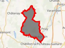
| |
 Villette-sur-Ain  Villette-sur-Ain | |
| Coordinates: 45°59′14″N 5°16′06″E | |
| Country | France |
| Region | Auvergne-Rhône-Alpes |
| Department | Ain |
| Arrondissement | Bourg-en-Bresse |
| Canton | Ceyzériat |
| Intercommunality | Chalamont |
| Government | |
| • Mayor (2008–2014) | Jean-Pierre Humbert |
| Area 1 | 19.38 km2 (7.48 sq mi) |
| Population (2017-01-01)[1] | 755 |
| • Density | 39/km2 (100/sq mi) |
| Time zone | UTC+01:00 (CET) |
| • Summer (DST) | UTC+02:00 (CEST) |
| INSEE/Postal code | 01449 /01320 |
| Elevation | 222–331 m (728–1,086 ft) (avg. 235 m or 771 ft) |
| 1 French Land Register data, which excludes lakes, ponds, glaciers > 1 km2 (0.386 sq mi or 247 acres) and river estuaries. | |
Population
|
|
See also
References
- "Populations légales 2017". INSEE. Retrieved 6 January 2020.
External links
| Wikimedia Commons has media related to Villette-sur-Ain. |
This article is issued from Wikipedia. The text is licensed under Creative Commons - Attribution - Sharealike. Additional terms may apply for the media files.