Collonges, Ain
Collonges is a commune in the Ain department in eastern France. Just outside the village is Fort l'Écluse.[2][3]
Collonges | |
|---|---|
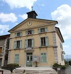 The town hall in Collonges | |
.svg.png.webp) Coat of arms | |
Location of Collonges 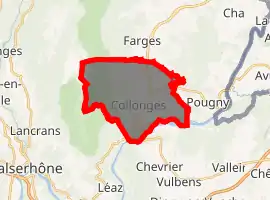
| |
 Collonges  Collonges | |
| Coordinates: 46°08′21″N 5°54′18″E | |
| Country | France |
| Region | Auvergne-Rhône-Alpes |
| Department | Ain |
| Arrondissement | Gex |
| Canton | Thoiry |
| Intercommunality | Pays de Gex Agglo |
| Government | |
| • Mayor (2014-2020) | André Duparc |
| Area 1 | 16.25 km2 (6.27 sq mi) |
| Population (2017-01-01)[1] | 2,219 |
| • Density | 140/km2 (350/sq mi) |
| Time zone | UTC+01:00 (CET) |
| • Summer (DST) | UTC+02:00 (CEST) |
| INSEE/Postal code | 01109 /01550 |
| Elevation | 329–1,621 m (1,079–5,318 ft) (avg. 500 m or 1,600 ft) |
| 1 French Land Register data, which excludes lakes, ponds, glaciers > 1 km2 (0.386 sq mi or 247 acres) and river estuaries. | |
Population
| Year | Pop. | ±% |
|---|---|---|
| 2004 | 1,119 | — |
| 2006 | 1,221 | +9.1% |
| 2007 | 1,421 | +16.4% |
| 2008 | 1,621 | +14.1% |
| 2009 | 1,821 | +12.3% |
| 2010 | 1,897 | +4.2% |
| 2011 | 1,979 | +4.3% |
| 2012 | 2,046 | +3.4% |
| 2013 | 2,104 | +2.8% |
| 2014 | 2,163 | +2.8% |
| 2015 | 2,195 | +1.5% |
| 2016 | 2,223 | +1.3% |
See also
References
- "Populations légales 2017". INSEE. Retrieved 6 January 2020.
- Collonges Fort L'Ecluse Archived 2008-09-17 at the Wayback Machine
- Inheritance museums and monuments: Fort l'Ecluse Archived 2008-07-20 at the Wayback Machine
| Wikimedia Commons has media related to Collonges, Ain. |
| Authority control |
|---|
This article is issued from Wikipedia. The text is licensed under Creative Commons - Attribution - Sharealike. Additional terms may apply for the media files.