Saint-Vulbas
Saint-Vulbas is a commune in the Ain department in eastern France.
Saint-Vulbas | |
|---|---|
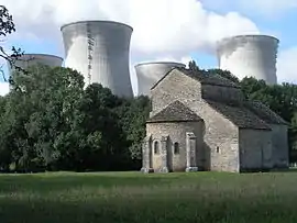 The chapel of Marcilleux | |
.svg.png.webp) Coat of arms | |
Location of Saint-Vulbas 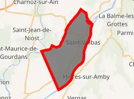
| |
 Saint-Vulbas  Saint-Vulbas | |
| Coordinates: 45°50′00″N 5°17′00″E | |
| Country | France |
| Region | Auvergne-Rhône-Alpes |
| Department | Ain |
| Arrondissement | Belley |
| Canton | Lagnieu |
| Intercommunality | Plaine de l'Ain |
| Government | |
| • Mayor (2008–2014) | Marcel Jacquin |
| Area 1 | 21.44 km2 (8.28 sq mi) |
| Population (2017-01-01)[1] | 1,286 |
| • Density | 60/km2 (160/sq mi) |
| Time zone | UTC+01:00 (CET) |
| • Summer (DST) | UTC+02:00 (CEST) |
| INSEE/Postal code | 01390 /01150 |
| Elevation | 192–227 m (630–745 ft) (avg. 207 m or 679 ft) |
| 1 French Land Register data, which excludes lakes, ponds, glaciers > 1 km2 (0.386 sq mi or 247 acres) and river estuaries. | |
Population
|
|
See also
References
- "Populations légales 2017". INSEE. Retrieved 6 January 2020.
| Wikimedia Commons has media related to Saint-Vulbas. |
| Authority control |
|---|
This article is issued from Wikipedia. The text is licensed under Creative Commons - Attribution - Sharealike. Additional terms may apply for the media files.