Saint-Paul-de-Varax
Saint-Paul-de-Varax is a commune in the Ain department in eastern France.
Saint-Paul-de-Varax | |
|---|---|
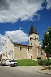 Church | |
Location of Saint-Paul-de-Varax 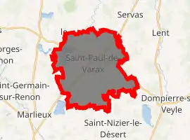
| |
 Saint-Paul-de-Varax  Saint-Paul-de-Varax | |
| Coordinates: 46°05′59″N 5°07′44″E | |
| Country | France |
| Region | Auvergne-Rhône-Alpes |
| Department | Ain |
| Arrondissement | Bourg-en-Bresse |
| Canton | Châtillon-sur-Chalaronne |
| Intercommunality | Centre Dombes |
| Government | |
| • Mayor (2020–2026) | Franck Sucillon |
| Area 1 | 25.97 km2 (10.03 sq mi) |
| Population (2017-01-01)[1] | 1,529 |
| • Density | 59/km2 (150/sq mi) |
| Time zone | UTC+01:00 (CET) |
| • Summer (DST) | UTC+02:00 (CEST) |
| INSEE/Postal code | 01383 /01240 |
| Elevation | 245–281 m (804–922 ft) (avg. 268 m or 879 ft) |
| 1 French Land Register data, which excludes lakes, ponds, glaciers > 1 km2 (0.386 sq mi or 247 acres) and river estuaries. | |
It is situated between Bourg-en-Bresse and Lyon. Its castle, which belonged to the Rivérieulx de Varax family since the 13th century, is closed to the public.
Population
|
|
See also
References
- "Populations légales 2017". INSEE. Retrieved 6 January 2020.
External links
| Wikimedia Commons has media related to Saint-Paul-de-Varax. |
This article is issued from Wikipedia. The text is licensed under Creative Commons - Attribution - Sharealike. Additional terms may apply for the media files.