Asnières-sur-Saône
Asnières-sur-Saône is a commune in the Ain department in the Auvergne-Rhône-Alpes region of eastern France.
Asnières-sur-Saône | |
|---|---|
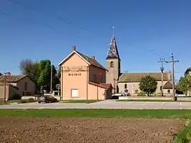 The Town Hall and the Church | |
Location of Asnières-sur-Saône 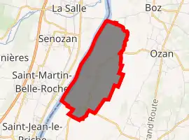
| |
 Asnières-sur-Saône  Asnières-sur-Saône | |
| Coordinates: 46°22′59″N 4°52′59″E | |
| Country | France |
| Region | Auvergne-Rhône-Alpes |
| Department | Ain |
| Arrondissement | Bourg-en-Bresse |
| Canton | Replonges |
| Intercommunality | Bresse et Saône |
| Government | |
| • Mayor (2014-2020) | Jean-Marc Willems |
| Area 1 | 4.7 km2 (1.8 sq mi) |
| Population (2017-01-01)[1] | 66 |
| • Density | 14/km2 (36/sq mi) |
| Time zone | UTC+01:00 (CET) |
| • Summer (DST) | UTC+02:00 (CEST) |
| INSEE/Postal code | 01023 /01570 |
| Elevation | 167–175 m (548–574 ft) |
| 1 French Land Register data, which excludes lakes, ponds, glaciers > 1 km2 (0.386 sq mi or 247 acres) and river estuaries. | |
The inhabitants of the commune are known as Asniérois or Asniéroises[2]
Geography
Asnières-sur-Saône is on the bank of the Saône river some 15 km north of Mâcon and 50 km south of Chalons-sur-Saône. The commune can be accessed on the D18 road from Quart-d'Aval in the north-east to the village. The road continues south as the D1 road then turns south-east to Manziat. The D1E branches off in the south of the commune and goes south to Le Chateau. The commune consists entirely of farmland with no other villages or hamlets.[3]
The Saône river forms the entire western border of the commune with no bridges across the river. A canal runs parallel to the river joining the river in the south and joining the Bief de la Jutane in the north which forms part of the northern border.[3]
Neighbouring communes and villages | ||||||||||
|---|---|---|---|---|---|---|---|---|---|---|
| ||||||||||
History
The village can be traced back to the 10th century under the name Asnerias. It was the possession of the Counts of Mâcon and Cluny Abbey.
Administration
Mayors of Asnières-sur-Saône[4]
| From | To | Name | Party | Position |
|---|---|---|---|---|
| 1998 | 2005 | Roland Golin | Territorial Official | |
| 2005 | Present | Jean-Marc Willems |
(Not all data is known)
Population
| Year | Pop. | ±% |
|---|---|---|
| 2004 | 86 | — |
| 2006 | 92 | +7.0% |
| 2007 | 86 | −6.5% |
| 2008 | 79 | −8.1% |
| 2009 | 73 | −7.6% |
| 2010 | 73 | +0.0% |
| 2011 | 73 | +0.0% |
| 2012 | 72 | −1.4% |
| 2013 | 69 | −4.2% |
| 2014 | 66 | −4.3% |
| 2015 | 64 | −3.0% |
| 2016 | 63 | −1.6% |
Sites and monuments
- The Port of Asnières
Protected natural areas
The floodplains of the Val de Saône have been classified as protected areas since 1994.[6]
Notable people linked to the commune
- José Mingret (1880-1969), French painter, was buried in Asnieres-sur-Saône.
See also
External links
Notes and references
Notes
References
- "Populations légales 2017". INSEE. Retrieved 6 January 2020.
- Inhabitants of Ain (in French)
- Google Maps
- List of Mayors of France (in French)
- National Commission for Decentralised cooperation (in French)
- Protection Zone of the wetlands of the Val de Saône, préfectorial directive of 25 February, Préfecture of Ain (in French)
| Wikimedia Commons has media related to Asnières-sur-Saône. |