Brewster, Nebraska
Brewster is a village in, and the county seat of,[5] Blaine County, Nebraska, United States. The population was 17 at the 2010 census.
Brewster, Nebraska | |
|---|---|
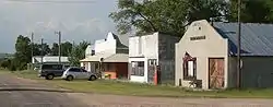 Downtown Brewster | |
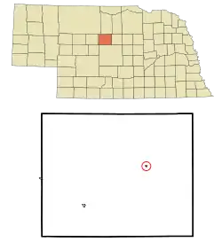 Location of Brewster, Nebraska | |
| Coordinates: 41°56′18″N 99°51′56″W | |
| Country | United States |
| State | Nebraska |
| County | Blaine |
| Area | |
| • Total | 0.09 sq mi (0.23 km2) |
| • Land | 0.09 sq mi (0.23 km2) |
| • Water | 0.00 sq mi (0.00 km2) |
| Elevation | 2,493 ft (760 m) |
| Population | |
| • Total | 17 |
| • Estimate (2019)[3] | 17 |
| • Density | 191.01/sq mi (74.16/km2) |
| Time zone | UTC−6 (Central (CST)) |
| • Summer (DST) | UTC−5 (CDT) |
| ZIP code | 68821 |
| Area code(s) | 308 |
| FIPS code | 31-06260 |
| GNIS feature ID | 0827637[4] |
History
The town was laid out in 1884 by George Washington Brewster who had homesteaded the land there. It was named for one of his ancestors, William Brewster, who had arrived in America on the Mayflower. The community was named the county seat in 1887 after George Washington Brewster offered to build the required buildings. According to town lore, Brewster had expected the state capitol to be located in the community because of its central location.[6]
In 1887 the outlaw D.C."Doc" Middleton opened a saloon in the community.[6]
Brewster almost became a railhead, when the Chicago, Burlington and Quincy Railroad graded a line from Sargent in 1897.[7] The line would have had an intermediate station at Moulton.[8]
Following the 2010 census Brewster became the smallest incorporated county seat in the United States replacing Amidon, North Dakota for the title. Amidon had 26 people in 2000 and Brewster had 29. In the 2010 census Brewster had 17 while Amidon had 20.
There are two other unincorporated county seats in the same range -- Mentone, Texas (population 19), the county seat of Loving County and Gann Valley, South Dakota (population 14), the county seat of Buffalo County, South Dakota.[9]
Geography
Brewster is located at 41°56′18″N 99°51′56″W (41.938374, -99.865492).[10] According to the United States Census Bureau, the village has a total area of 0.09 square miles (0.23 km2), all land.[11]
Climate
Brewster has a subhumid continental climate (Köppen Dfa/Dwa/Dfb/Dwb) with summers featuring hot afternoons, comfortable mornings, and occasional heavy rain, and winters that are generally freezing but vary from mild with chinook winds to frigid Arctic conditions.
| Climate data for Brewster, Nebraska (1971–2000; extremes 1948−2001) | |||||||||||||
|---|---|---|---|---|---|---|---|---|---|---|---|---|---|
| Month | Jan | Feb | Mar | Apr | May | Jun | Jul | Aug | Sep | Oct | Nov | Dec | Year |
| Record high °F (°C) | 72 (22) |
81 (27) |
86 (30) |
93 (34) |
99 (37) |
108 (42) |
109 (43) |
105 (41) |
100 (38) |
93 (34) |
82 (28) |
73 (23) |
109 (43) |
| Average high °F (°C) | 33.9 (1.1) |
39.1 (3.9) |
48.7 (9.3) |
60.4 (15.8) |
70.7 (21.5) |
81.3 (27.4) |
87.3 (30.7) |
85.6 (29.8) |
76.8 (24.9) |
64.7 (18.2) |
46.8 (8.2) |
37.1 (2.8) |
61.0 (16.1) |
| Daily mean °F (°C) | 20.2 (−6.6) |
25.5 (−3.6) |
34.7 (1.5) |
45.7 (7.6) |
56.6 (13.7) |
66.8 (19.3) |
72.7 (22.6) |
70.6 (21.4) |
60.7 (15.9) |
48.4 (9.1) |
32.8 (0.4) |
23.4 (−4.8) |
46.5 (8.1) |
| Average low °F (°C) | 6.5 (−14.2) |
11.8 (−11.2) |
20.6 (−6.3) |
30.9 (−0.6) |
42.4 (5.8) |
52.2 (11.2) |
58.1 (14.5) |
55.6 (13.1) |
44.5 (6.9) |
32.0 (0.0) |
18.7 (−7.4) |
9.6 (−12.4) |
31.9 (−0.1) |
| Record low °F (°C) | −34 (−37) |
−35 (−37) |
−26 (−32) |
2 (−17) |
19 (−7) |
32 (0) |
38 (3) |
37 (3) |
18 (−8) |
6 (−14) |
−20 (−29) |
−35 (−37) |
−35 (−37) |
| Average precipitation inches (mm) | 0.41 (10) |
0.64 (16) |
1.33 (34) |
1.90 (48) |
3.58 (91) |
3.72 (94) |
3.23 (82) |
3.06 (78) |
1.75 (44) |
1.36 (35) |
1.03 (26) |
0.53 (13) |
22.54 (571) |
| Average snowfall inches (cm) | 5.6 (14) |
4.6 (12) |
5.2 (13) |
1.3 (3.3) |
0.0 (0.0) |
0.0 (0.0) |
0.0 (0.0) |
0.0 (0.0) |
0.1 (0.25) |
1.2 (3.0) |
6.8 (17) |
4.3 (11) |
29.1 (73.55) |
| Average precipitation days (≥ 0.01 inch) | 2.9 | 3.2 | 5.2 | 7.4 | 9.3 | 9.0 | 7.7 | 6.7 | 5.8 | 4.4 | 3.7 | 2.7 | 68 |
| Average snowy days (≥ 0.1 inch) | 2.3 | 2.0 | 2.1 | 1.0 | 0.0 | 0.0 | 0.0 | 0.0 | 0.1 | 0.5 | 1.7 | 1.8 | 11.5 |
| Source: NOAA (normals, 1971–2000)[12] | |||||||||||||
Demographics
| Historical population | |||
|---|---|---|---|
| Census | Pop. | %± | |
| 1950 | 69 | — | |
| 1960 | 44 | −36.2% | |
| 1970 | 54 | 22.7% | |
| 1980 | 46 | −14.8% | |
| 1990 | 22 | −52.2% | |
| 2000 | 29 | 31.8% | |
| 2010 | 17 | −41.4% | |
| 2019 (est.) | 17 | [3] | 0.0% |
| U.S. Decennial Census[13] 2012 Estimate[14] | |||
2010 census
As of the census[2] of 2010, there were 17 people, 8 households, and 6 families residing in the village. The population density was 188.9 inhabitants per square mile (72.9/km2). There were 21 housing units at an average density of 233.3 per square mile (90.1/km2). The racial makeup of the village was 100.0% White.
There were 8 households, of which 12.5% had children under the age of 18 living with them, 75.0% were married couples living together, and 25.0% were non-families. 25.0% of all households were made up of individuals, and 25% had someone living alone who was 65 years of age or older. The average household size was 2.13 and the average family size was 2.50.
The median age in the village was 61.8 years. 17.6% of residents were under the age of 18; 0.1% were between the ages of 18 and 24; 5.9% were from 25 to 44; 35.3% were from 45 to 64; and 41.2% were 65 years of age or older. The gender makeup of the village was 58.8% male and 41.2% female.
2000 census
As of the census of 2000, there were 29 people, 12 households, and 9 families residing in the village. The population density was 333.8 people per square mile (124.4/km2). There were 20 housing units at an average density of 230.2 per square mile (85.8/km2). The racial makeup of the village was 100.00% White.
There were 12 households, out of which 16.7% had children under the age of 18 living with them, 75.0% were married couples living together, and 16.7% were non-families. 16.7% of all households were made up of individuals, and 8.3% had someone living alone who was 65 years of age or older. The average household size was 2.42 and the average family size was 2.70.
In the village, the population was spread out, with 24.1% under the age of 18, 6.9% from 18 to 24, 20.7% from 25 to 44, 37.9% from 45 to 64, and 10.3% who were 65 years of age or older. The median age was 42 years. For every 100 females, there were 81.3 males. For every 100 females age 18 and over, there were 100.0 males.
As of 2000 the median income for a household in the village was $37,500, and the median income for a family was $51,250. Males had a median income of $26,250 versus $28,750 for females. The per capita income for the village was $12,840. There were 33.3% of families and 20.0% of the population living below the poverty line, including no under eighteens and none of those over 64.
Notable person
- Milly Bernard - Member of the Utah House of Representatives from 1966 to 1976.
In popular culture
- Finn Sawyer, a character on the Disney Channel series Bunk'd, is from Brewster.
References
- "2019 U.S. Gazetteer Files". United States Census Bureau. Retrieved July 26, 2020.
- "U.S. Census website". United States Census Bureau. Retrieved 2012-06-24.
- "Population and Housing Unit Estimates". United States Census Bureau. May 24, 2020. Retrieved May 27, 2020.
- "US Board on Geographic Names". United States Geological Survey. 2007-10-25. Retrieved 2008-01-31.
- "Find a County". National Association of Counties. Archived from the original on 2011-05-31. Retrieved 2011-06-07.
- Schipporeit, Al. "Brewster--Blaine County". Nebraska... Our Towns. Archived 2011-11-23 at the Wayback Machine Retrieved 2013-07-27.
- "Blaine News and Tidbits". Retrieved 15 January 2020.
- Twentieth Century Peerless Atlas Crowell Publishing 1908, Nebraska map
- "2010 Census Redistricting Data (Public Law 94-171) Summary File". American FactFinder. United States Census Bureau. Retrieved 2 May 2011.
- "US Gazetteer files: 2010, 2000, and 1990". United States Census Bureau. 2011-02-12. Retrieved 2011-04-23.
- "US Gazetteer files 2010". United States Census Bureau. Archived from the original on 2012-01-25. Retrieved 2012-06-24.
- "Climatography of the United States NO.81" (PDF). National Oceanic and Atmospheric Administration. Retrieved January 11, 2011.
- United States Census Bureau. "Census of Population and Housing". Retrieved October 19, 2013.
- "Annual Estimates of the Resident Population: April 1, 2010 to July 1, 2012". Archived from the original on October 19, 2013. Retrieved October 19, 2013.
Municipalities and communities of Blaine County, Nebraska, United States | ||
|---|---|---|
| Villages | Map of Nebraska highlighting Blaine County | |
| Unincorporated communities | ||
| Footnotes | ‡This populated place also has portions in an adjacent county or counties | |
| ||
