National Register of Historic Places listings in Clinton County, Iowa
This is a list of the National Register of Historic Places listings in Clinton County, Iowa.
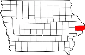
Location of Clinton County in Iowa
This is intended to be a complete list of the properties and districts on the National Register of Historic Places in Clinton County, Iowa, United States. Latitude and longitude coordinates are provided for many National Register properties and districts; these locations may be seen together in a map.[1]
There are 30 properties and districts listed on the National Register in the county, including one National Historic Landmark.
- This National Park Service list is complete through NPS recent listings posted February 5, 2021.[2]
Current listings
| [3] | Name on the Register[4] | Image | Date listed[5] | Location | City or town | Description |
|---|---|---|---|---|---|---|
| 1 | Ames Creek Bridge | 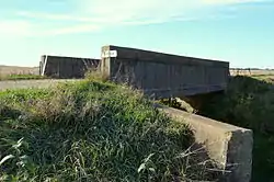 Ames Creek Bridge |
June 25, 1998 (#98000802) |
300th St. over Ames Creek 41°51′01″N 90°30′36″W |
DeWitt | part of the Highway Bridges of Iowa Multiple Property Submission (MPS) |
| 2 | Ankeny Building | 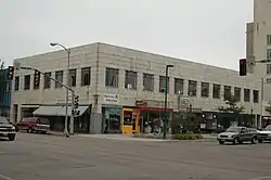 Ankeny Building |
March 2, 2006 (#06000105) |
201 5th Ave., S. 41°50′34″N 90°11′18″W |
Clinton | part of the Clinton, Iowa MPS |
| 3 | Horace Anthony House | 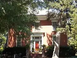 Horace Anthony House |
May 1, 1991 (#91000533) |
1206 Anthony Pl. 41°46′52″N 90°15′31″W |
Camanche | |
| 4 | Castle Terrace Historic District | 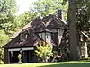 Castle Terrace Historic District |
January 7, 1998 (#97001607) |
Roughly along the junction of Terrace Dr. and Caroline Ave. 41°50′17″N 90°13′02″W |
Clinton | part of the Clinton, Iowa MPS |
| 5 | Cherry Bank | 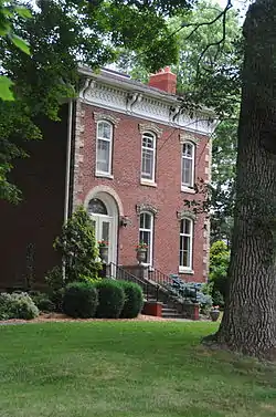 Cherry Bank |
November 22, 1999 (#99001382) |
1458 Main Ave. 41°52′28″N 90°12′28″W |
Clinton | |
| 6 | Chicago, Milwaukee, St. Paul & Pacific Depot- Delmar | 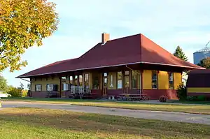 Chicago, Milwaukee, St. Paul & Pacific Depot- Delmar |
April 14, 1997 (#97000308) |
West of Main St., between Railroad St. and Clinton Ave. 42°00′05″N 90°36′30″W |
Delmar | part of the Advent & Development of Railroads in Iowa MPS |
| 7 | City Hotel | .JPG.webp) City Hotel |
October 3, 2007 (#07001031) |
214 S. Main St. 41°49′51″N 90°50′20″W |
Wheatland | |
| 8 | Clinton County Courthouse |  Clinton County Courthouse |
July 2, 1981 (#81000230) |
Between 6th and 7th Aves. 41°51′02″N 90°11′17″W |
Clinton | part of the County Courthouses in Iowa Thematic Resource (TR) |
| 9 | Clinton High School and Public Library | 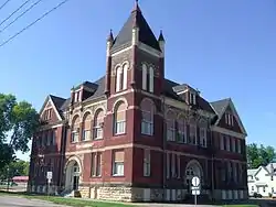 Clinton High School and Public Library |
September 19, 2012 (#12000792) |
600 S. 4th St. 41°50′24″N 90°11′36″W |
Clinton | part of the Clinton, Iowa MPS |
| 10 | Clinton Public Library | 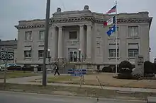 Clinton Public Library |
May 23, 1983 (#83000349) |
306 8th Ave, S. 41°50′17″N 90°11′29″W |
Clinton | part of the Public Library Buildings in Iowa TR |
| 11 | George M. Curtis House | 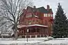 George M. Curtis House |
October 1, 1979 (#79000892) |
420 S. 5th Ave. 41°50′28″N 90°11′40″W |
Clinton | |
| 12 | Delmar Calaboose | 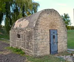 Delmar Calaboose |
March 19, 1981 (#81000231) |
Vane St. 42°00′02″N 90°36′21″W |
Delmar | |
| 13 | Peter Dierks House | 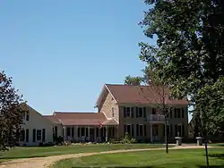 Peter Dierks House |
December 30, 1998 (#98001543) |
Iowa Highway 136, 5 miles (8.0 km) west of Clinton 41°53′59″N 90°16′22″W |
Clinton | |
| 14 | Dugan's Saloon | 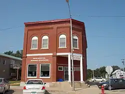 Dugan's Saloon |
August 30, 2001 (#01000908) |
516 Smith St. 41°49′26″N 90°38′53″W |
Grand Mound | |
| 15 | Farmers and Merchants Savings Bank | .JPG.webp) Farmers and Merchants Savings Bank |
August 30, 2001 (#01000909) |
601 Smith St. 41°49′27″N 90°38′50″W |
Grand Mound | |
| 16 | First National Bank | 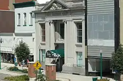 First National Bank |
October 10, 1985 (#85003007) |
226 5th Ave., S. 41°50′28″N 90°11′21″W |
Clinton | |
| 17 | Grand Mound Town Hall and Waterworks Historic District | 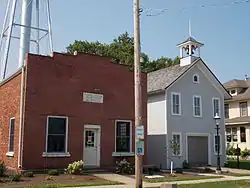 Grand Mound Town Hall and Waterworks Historic District |
August 30, 2001 (#01000910) |
613-615 Clinton St. 41°49′26″N 90°38′58″W |
Grand Mound | |
| 18 | Helvig-Olson Farm Historic District | 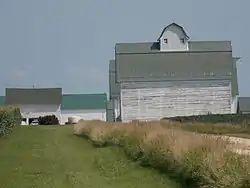 Helvig-Olson Farm Historic District |
August 15, 2000 (#00000924) |
2008 260th St. 41°48′14″N 90°42′05″W |
Grand Mound | part of the Norwegian Related Resources of Olive Township, Clinton County, Iowa MPS |
| 19 | Howes Building | 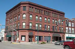 Howes Building |
December 15, 2004 (#04001351) |
419-425 2nd St., S. 41°50′30″N 90°11′15″W |
Clinton | |
| 20 | George Johnson House | .JPG.webp) George Johnson House |
August 15, 2000 (#00000923) |
2566 190th Ave. 41°48′18″N 90°43′26″W |
Calamus | part of the Norwegian Related Resources of Olive Township, Clinton County, Iowa MPS |
| 21 | Kvindherred Lutheran Church, School and Cemetery | _02.JPG.webp) Kvindherred Lutheran Church, School and Cemetery |
August 15, 2000 (#00000922) |
2589 190th Ave. 41°48′26″N 90°43′26″W |
Calamus | part of the Norwegian Related Resources of Olive Township, Clinton County, Iowa MPS |
| 22 | Lafayette Lamb House | .JPG.webp) Lafayette Lamb House |
October 18, 1979 (#79000893) |
317 7th Ave., S. 41°50′19″N 90°11′30″W |
Clinton | |
| 23 | Moeszinger-Marquis Hardware Co. | _Building.JPG.webp) Moeszinger-Marquis Hardware Co. |
February 9, 2006 (#06000004) |
721 2nd St., S. 41°50′26″N 90°11′18″W |
Clinton | part of the Clinton, Iowa MPS |
| 24 | Saint Boniface Church | 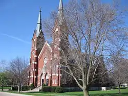 Saint Boniface Church |
February 24, 2012 (#97000386) |
2500 N. Pershing Blvd. 41°52′27″N 90°10′50″W |
Clinton | |
| 25 | Saint Irenaeus Church | 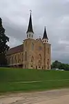 Saint Irenaeus Church |
September 3, 2010 (#96001589) |
2811 N. 2nd St. 41°52′41″N 90°10′40″W |
Clinton | |
| 26 | Sharon Methodist Episcopal Church | 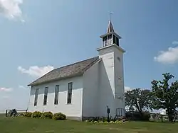 Sharon Methodist Episcopal Church |
August 14, 2003 (#03000745) |
1223 125th St. 41°59′43″N 90°51′18″W |
Lost Nation | |
| 27 | Van Allen Store | 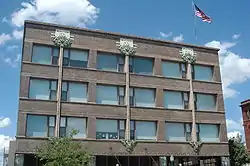 Van Allen Store |
January 7, 1976 (#76000753) |
5th Ave. and S. 2nd St. 41°50′29″N 90°11′18″W |
Clinton | |
| 28 | Washington Junior High School and Jefferson Grade School | 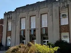 Washington Junior High School and Jefferson Grade School |
October 21, 2015 (#15000483) |
751 2nd Ave. S. 41°50′40″N 90°12′12″W |
Clinton | |
| 29 | Wilson Buildings | 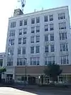 Wilson Buildings |
February 5, 2014 (#13001135) |
211–219 5th Ave. S 41°50′27″N 90°11′21″W |
Clinton | |
| 30 | Wilson District No. 7 School | 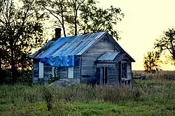 Wilson District No. 7 School |
December 6, 2004 (#04001320) |
1507 270th Ave. 41°57′32″N 90°34′05″W |
Delmar |
Former listings
| [3] | Name on the Register | Image | Date listed | Date removed | Location | City or town | Summary |
|---|---|---|---|---|---|---|---|
| 1 | W. J. Young Company Machine Works | .tiff.jpg.webp) W. J. Young Company Machine Works |
June 17, 1976 (#76000754) | Unknown | N of jct. of 10th Ave. and 1st St. |
Clinton |
See also
| Wikimedia Commons has media related to National Register of Historic Places in Clinton County, Iowa. |
References
- The latitude and longitude information provided in this table was derived originally from the National Register Information System, which has been found to be fairly accurate for about 99% of listings. Some locations in this table may have been corrected to current GPS standards.
- "National Register of Historic Places: Weekly List Actions". National Park Service, United States Department of the Interior. Retrieved on February 5, 2021.
- Numbers represent an alphabetical ordering by significant words. Various colorings, defined here, differentiate National Historic Landmarks and historic districts from other NRHP buildings, structures, sites or objects.
- "National Register Information System". National Register of Historic Places. National Park Service. April 24, 2008.
- The eight-digit number below each date is the number assigned to each location in the National Register Information System database, which can be viewed by clicking the number.
| Topics | |
|---|---|
| Lists by state |
|
| Lists by insular areas | |
| Lists by associated state | |
| Other areas | |
| Related | |
| |

Municipalities and communities of Clinton County, Iowa, United States | ||
|---|---|---|
| Cities | Map of Iowa highlighting Clinton County | |
| Townships | ||
| Unincorporated communities | ||
| Footnotes | ‡This populated place also has portions in an adjacent county or counties | |
| ||
This article is issued from Wikipedia. The text is licensed under Creative Commons - Attribution - Sharealike. Additional terms may apply for the media files.