L'Abergement-Clémenciat
L'Abergement-Clémenciat is a commune in the department of Ain and the region of Auvergne-Rhône-Alpes in eastern Metropolitan France. The commune was established in 1857 by combining the two parishes of Abergement and Clémenciat.
L'Abergement-Clémenciat | |
|---|---|
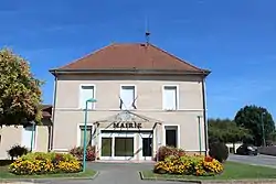 The town hall in L'Abergement-Clémenciat | |
Location of L'Abergement-Clémenciat 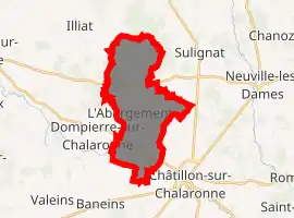
| |
 L'Abergement-Clémenciat  L'Abergement-Clémenciat | |
| Coordinates: 46°09′07″N 4°55′18″E | |
| Country | France |
| Region | Auvergne-Rhône-Alpes |
| Department | Ain |
| Arrondissement | Bourg-en-Bresse |
| Canton | Châtillon-sur-Chalaronne |
| Intercommunality | Dombes |
| Government | |
| • Mayor (2020–2026) | Daniel Boulon |
| Area 1 | 15.95 km2 (6.16 sq mi) |
| Population (2017-01-01)[1] | 776 |
| • Density | 49/km2 (130/sq mi) |
| Time zone | UTC+01:00 (CET) |
| • Summer (DST) | UTC+02:00 (CEST) |
| INSEE/Postal code | 01001 /01400 |
| Elevation | 206–272 m (676–892 ft) (avg. 240 m or 790 ft) |
| 1 French Land Register data, which excludes lakes, ponds, glaciers > 1 km2 (0.386 sq mi or 247 acres) and river estuaries. | |
Geography
L'Abergement-Clémenciat lies on the border between Bresse and Dombes at an altitude of 206 to 272 meters. The commune sits on an area of 1,596 hectares. Other communes near-by include Châtillon-sur-Chalaronne, Illiat, Sulignat, Thoissey, Saint-Étienne-sur-Chalaronne, and Dompierre-sur-Chalaronne. The closest big cities are Lyon, and Geneva.
Hydrography
- The Chalaronne flows west-northwest through the southern part of the commune.
- The Glenne forms the northern border with the commune of Illiat. It empties into the Chalaronne at Saint-Étienne-sur-Chalaronne
- The Vernisson Canal forms the eastern border with Châtillon-sur-Chalaronne and it empties into the Chalaronne at Pontpeillon.
- The Payon Canal crosses the ash ponds at Châtillon.
Toponomy
There are 4 communes in Ain with the name of Jura on a river. The other three are Le Petit-Abergement, Le Grand-Abergement, and L'Abergement-de-Varey. It seems to designate agricultural concessions in the 11th-15th centuries.
History
It was once a large timber plantation.
Mayors
| Name | Term | Party | Qualifications | |
|---|---|---|---|---|
| 1857 | 1882 | Antoine-Élisée Munet | ||
| 1882 | 1912 | Melchior Munet | ||
| 1912 | 1944 | Élisée Munet | ||
| December 1944 | February 1945 | Paul Reverdy | ||
| February 1945 | May 1945 | Élisée Munet | ||
| May 1945 | October 1947 | Jean-Marie Beyoux | Radical socialist | |
| November 1947 | March 1971 | Joseph Jouard | ||
| March 1971 | June 1997 | René Perret | Independent | |
| June 1997 | March 2008 | Jean-Claude Rigaud | ||
| March 2008 | Current | Daniel Boulon | Independent | |
Population
| Year | Pop. | ±% |
|---|---|---|
| 2006 | 811 | — |
| 2007 | 804 | −0.9% |
| 2008 | 791 | −1.6% |
| 2009 | 787 | −0.5% |
| 2010 | 784 | −0.4% |
| 2011 | 780 | −0.5% |
| 2012 | 777 | −0.4% |
| 2013 | 767 | −1.3% |
| 2014 | 767 | +0.0% |
| 2015 | 767 | +0.0% |
| 2016 | 767 | +0.0% |
Sights
- The Vieux Bourg (old town) has been classified as a monument historique by the French Ministry of Culture since November 18, 1994.[2] All that remains of the castle is the ruins. The walls of the 14th century enceinte are visible.
- A château, built in 1700, rebuilt in the 19th century
- A church, consecrated in 1868, built under the direction of Louis-Auguste Boileau, an architect of Paris.
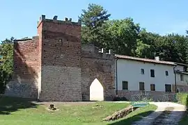 Vieux Bourg.
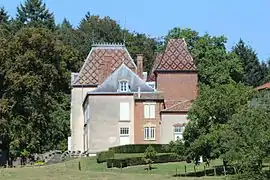 Château Munet.
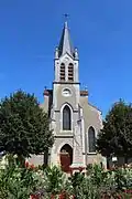 19th century church.
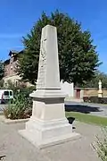 Monument to the dead.
See also
References
- "Populations légales 2017". INSEE. Retrieved 6 January 2020.
- Base Mérimée: Site médiéval du Vieux Bourg, Ministère français de la Culture. (in French)
External links
| Wikimedia Commons has media related to L'Abergement-Clémenciat. |
| Authority control |
|
|---|