National Register of Historic Places listings in Boone County, Iowa
This is a list of the National Register of Historic Places listings in Boone County, Iowa.
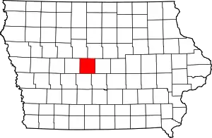
Location of Boone County in Iowa
This is intended to be a complete list of the properties and districts on the National Register of Historic Places in Boone County, Iowa, United States. Latitude and longitude coordinates are provided for many National Register properties and districts; these locations may be seen together in a map.[1]
There are 19 properties listed on the National Register in the county.
- This National Park Service list is complete through NPS recent listings posted February 5, 2021.[2]
| [3] | Name on the Register[4] | Image | Date listed[5] | Location | City or town | Description |
|---|---|---|---|---|---|---|
| 1 | Alonzo J. and Flora Barkley House | 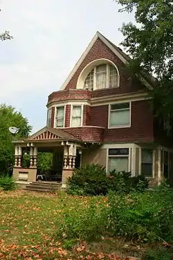 Alonzo J. and Flora Barkley House |
July 21, 1995 (#95000857) |
326 Boone St. 42°03′33″N 93°52′54″W |
Boone | |
| 2 | Beaver Creek Bridge |  Beaver Creek Bridge |
June 25, 1998 (#98000762) |
210th St. over Beaver Creek 42°02′57″N 94°08′31″W |
Ogden | |
| 3 | Big Creek Bridge | .jpg.webp) Big Creek Bridge |
June 25, 1998 (#98000766) |
2110 300th St. over Big Creek 41°55′18″N 93°45′23″W |
Madrid | |
| 4 | Big Creek Bridge 2 | 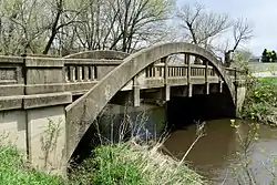 Big Creek Bridge 2 |
June 25, 1998 (#98000767) |
2130 320th St. over Big Creek 41°53′33″N 93°45′02″W |
Madrid | |
| 5 | Boone Bridge | June 25, 1998 (#98000761) |
Old U.S. Route 30 over the Des Moines River 42°02′32″N 93°56′00″W |
Boone | ||
| 6 | Boone Bridge 2 | 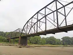 Boone Bridge 2 |
June 25, 1998 (#98000765) |
1000 200th St. over the Des Moines River 42°03′47″N 93°58′13″W |
Boone | |
| 7 | Boone County Courthouse | 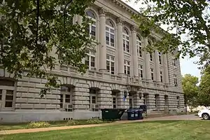 Boone County Courthouse |
July 2, 1981 (#81000226) |
N. State and W. 2nd Sts. 42°03′32″N 93°54′21″W |
Boone | |
| 8 | Boone Viaduct |  Boone Viaduct |
November 17, 1978 (#78001207) |
West of Boone 42°03′33″N 93°58′12″W |
Boone | |
| 9 | Carl and Ulrika Dalander Cassel House | 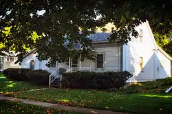 Carl and Ulrika Dalander Cassel House |
April 12, 1982 (#82002609) |
415 W. 2nd St. 41°52′32″N 93°49′31″W |
Madrid | |
| 10 | Champlin Memorial Masonic Temple | 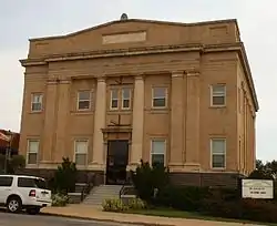 Champlin Memorial Masonic Temple |
December 20, 1990 (#90001853) |
602 Story St. 42°03′44″N 93°52′45″W |
Boone | |
| 11 | Des Moines Township #7 | July 12, 2019 (#100004212) |
843 R Ave. 42°05′08″N 93°50′06″W |
Boone | ||
| 12 | Ericson Public Library | 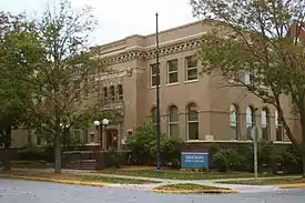 Ericson Public Library |
May 23, 1983 (#83000344) |
702 Greene St. 42°03′47″N 93°52′58″W |
Boone | |
| 13 | First National Bank |  First National Bank |
June 28, 1989 (#88003232) |
8th and Story Sts. 42°03′47″N 93°52′58″W |
Boone | |
| 14 | John H. Herman House | 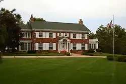 John H. Herman House |
June 28, 1989 (#88003233) |
711 S. Story St. 42°02′56″N 93°52′50″W |
Boone | |
| 15 | Perrigo-Holmes House | 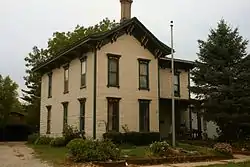 Perrigo-Holmes House |
September 8, 1994 (#94001102) |
721 Carroll St. 42°03′48″N 93°53′07″W |
Boone | |
| 16 | J.H. Riekenberg House | 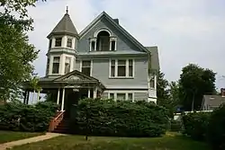 J.H. Riekenberg House |
April 11, 1988 (#87002017) |
310 N. Tama St. 42°03′32″N 93°52′34″W |
Boone | |
| 17 | Squaw Creek Bridge | June 25, 1998 (#98000763) |
120th St. and V Ave. over Squaw Creek 42°10′51″N 93°45′28″W |
Ridgeport | ||
| 18 | Squaw Creek Bridge 2 | 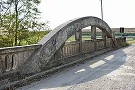 Squaw Creek Bridge 2 |
June 25, 1998 (#98000764) |
110th St. and V Ave. over Squaw Creek 42°11′44″N 93°46′31″W |
Ridgeport | |
| 19 | Stoll Bottling Works | 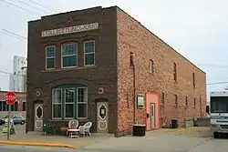 Stoll Bottling Works |
May 2, 1997 (#97000390) |
824 Allen St. 42°03′53″N 93°52′43″W |
Boone |
Former listings
| [3] | Name on the Register | Image | Date listed | Date removed | Location | City or town | Summary |
|---|---|---|---|---|---|---|---|
| 1 | Finnegan Flats | September 20, 1977 (#77000499) | Unknown | 710-718 7th St. |
Boone |
See also
| Wikimedia Commons has media related to National Register of Historic Places in Boone County, Iowa. |
References
- The latitude and longitude information provided in this table was derived originally from the National Register Information System, which has been found to be fairly accurate for about 99% of listings. Some locations in this table may have been corrected to current GPS standards.
- "National Register of Historic Places: Weekly List Actions". National Park Service, United States Department of the Interior. Retrieved on February 5, 2021.
- Numbers represent an alphabetical ordering by significant words. Various colorings, defined here, differentiate National Historic Landmarks and historic districts from other NRHP buildings, structures, sites or objects.
- "National Register Information System". National Register of Historic Places. National Park Service. April 24, 2008.
- The eight-digit number below each date is the number assigned to each location in the National Register Information System database, which can be viewed by clicking the number.
| Topics | |
|---|---|
| Lists by state |
|
| Lists by insular areas | |
| Lists by associated state | |
| Other areas | |
| Related | |
| |

Municipalities and communities of Boone County, Iowa, United States | ||
|---|---|---|
| Cities | Map of Iowa highlighting Boone County | |
| Townships | ||
| Unincorporated communities | ||
| Ghost town | ||
| Footnotes | ‡This populated place also has portions in an adjacent county or counties | |
| ||
This article is issued from Wikipedia. The text is licensed under Creative Commons - Attribution - Sharealike. Additional terms may apply for the media files.