National Register of Historic Places listings in Montgomery County, Iowa
This is a list of the National Register of Historic Places listings in Montgomery County, Iowa.
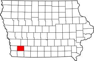
Location of Montgomery County in Iowa
This is intended to be a complete list of the properties and districts on the National Register of Historic Places in Montgomery County, Iowa, United States. Latitude and longitude coordinates are provided for many National Register properties and districts; these locations may be seen together in a map.[1]
There are 19 properties and districts listed on the National Register in the county, and one former listing.
- This National Park Service list is complete through NPS recent listings posted January 29, 2021.[2]
Current listings
| [3] | Name on the Register[4] | Image | Date listed[5] | Location | City or town | Description |
|---|---|---|---|---|---|---|
| 1 | Chautauqua Park | .jpg.webp) Chautauqua Park |
May 19, 1972 (#72000479) |
Oak St. 41°01′00″N 95°13′17″W |
Red Oak | |
| 2 | Chicago, Burlington Northern and Quincy Depot | 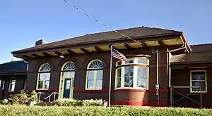 Chicago, Burlington Northern and Quincy Depot |
April 29, 1999 (#99000489) |
305 S. 2nd St. 41°00′08″N 95°13′51″W |
Red Oak | |
| 3 | William and Amanda J. Ellis Farmstead Historic District | October 23, 2015 (#15000752) |
1134 I Ave. 41°08′26″N 95°12′50″W |
Elliott vicinity | ||
| 4 | Grant Commercial Historic District | September 12, 2002 (#02001031) |
Parts of 2nd St. and U Ave. 41°08′31″N 94°59′03″W |
Grant | ||
| 5 | Alfred Hebard House | 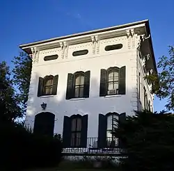 Alfred Hebard House |
April 12, 1984 (#84001290) |
700 8th St. 41°00′39″N 95°13′22″W |
Red Oak | |
| 6 | Montgomery County Courthouse | 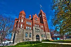 Montgomery County Courthouse |
July 2, 1981 (#81000259) |
Coolbaugh and 2nd Sts. 41°00′34″N 95°13′50″W |
Red Oak | |
| 7 | Montgomery County Jail | December 18, 1992 (#92001661) |
100 W. Coolbaugh St. 41°00′31″N 95°13′55″W |
Red Oak | ||
| 8 | Josiah B. and Sara Moore House | 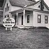 Josiah B. and Sara Moore House |
December 1, 1997 (#97001471) |
508 E. 2nd St. 40°55′50″N 94°58′23″W |
Villisca | |
| 9 | Thos. D. Murphy Co. Factory and Power Plant | 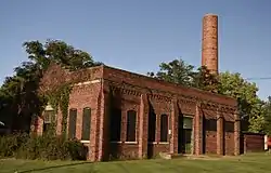 Thos. D. Murphy Co. Factory and Power Plant |
May 19, 2008 (#08000505) |
110 S. 2nd St. 41°00′17″N 95°13′49″W |
Red Oak | |
| 10 | Nodaway River Bridge |  Nodaway River Bridge |
May 15, 1998 (#98000494) |
Pedestrian path in Pilot Grove County Park 41°08′52″N 95°02′31″W |
Grant | |
| 11 | Edmund B. Osborne House | 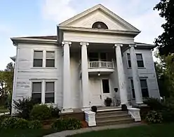 Edmund B. Osborne House |
October 30, 1997 (#97001287) |
1020 Boundary St. 41°00′48″N 95°13′13″W |
Red Oak | |
| 12 | Red Oak Downtown Historic District | 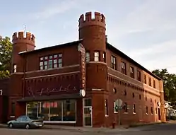 Red Oak Downtown Historic District |
December 20, 2016 (#16000868) |
Roughly bound by E. Hammond, N.5th, N. 1 Sts., E. Washington Ave. 41°00′32″N 95°13′45″W |
Red Oak | |
| 13 | Red Oak Firehouse and City Jail | 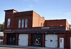 Red Oak Firehouse and City Jail |
January 11, 2006 (#05001508) |
318 E. Washington Ave. 41°00′28″N 95°13′42″W |
Red Oak | |
| 14 | Red Oak High School | June 22, 2020 (#100005294) |
308 East Corning St. 41°00′40″N 95°13′43″W |
Red Oak | ||
| 15 | Red Oak Public Library | Red Oak Public Library |
May 23, 1983 (#83000394) |
2nd and Washington Sts. 41°05′31″N 95°14′50″W |
Red Oak | |
| 16 | Round Barn, Pilot Grove Township | June 30, 1986 (#86001467) |
County Road H20 41°06′21″N 95°04′50″W |
Pilot Grove Township | ||
| 17 | Round Barn, Washington Township | June 30, 1986 (#86001466) |
U.S. Route 71 41°03′39″N 94°59′01″W |
Washington Township | ||
| 18 | Sciola Missionary Baptist Church | July 18, 1983 (#83000395) |
U.S. Route 71 41°02′03″N 94°59′09″W |
Sciola | ||
| 19 | Villisca National Guard Armory | 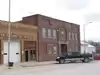 Villisca National Guard Armory |
May 18, 2015 (#15000227) |
316 E. 3rd St. 40°55′47″N 94°58′35″W |
Villisca |
See also
| Wikimedia Commons has media related to National Register of Historic Places in Montgomery County, Iowa. |
References
- The latitude and longitude information provided in this table was derived originally from the National Register Information System, which has been found to be fairly accurate for about 99% of listings. Some locations in this table may have been corrected to current GPS standards.
- "National Register of Historic Places: Weekly List Actions". National Park Service, United States Department of the Interior. Retrieved on January 29, 2021.
- Numbers represent an alphabetical ordering by significant words. Various colorings, defined here, differentiate National Historic Landmarks and historic districts from other NRHP buildings, structures, sites or objects.
- "National Register Information System". National Register of Historic Places. National Park Service. April 24, 2008.
- The eight-digit number below each date is the number assigned to each location in the National Register Information System database, which can be viewed by clicking the number.
| Topics | |
|---|---|
| Lists by state |
|
| Lists by insular areas | |
| Lists by associated state | |
| Other areas | |
| Related | |
| |

Municipalities and communities of Montgomery County, Iowa, United States | ||
|---|---|---|
| Cities | Map of Iowa highlighting Montgomery County | |
| Townships | ||
| Unincorporated communities | ||
| ||
This article is issued from Wikipedia. The text is licensed under Creative Commons - Attribution - Sharealike. Additional terms may apply for the media files.