National Register of Historic Places listings in Wright County, Iowa
This is intended to be a complete list of the properties and districts on the National Register of Historic Places in Wright County, Iowa, United States. Latitude and longitude coordinates are provided for many National Register properties and districts; these locations may be seen together in a map.[1]
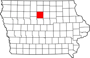
Location of Wright County in Iowa
There are 8 properties and districts listed on the National Register in the county, including one National Historic Landmark. Two properties were formerly listed on the National Register.
- This National Park Service list is complete through NPS recent listings posted January 29, 2021.[2]
| [3] | Name on the Register[4] | Image | Date listed[5] | Location | City or town | Description |
|---|---|---|---|---|---|---|
| 1 | Boone River Bridge | 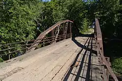 Boone River Bridge |
May 15, 1998 (#98000457) |
Buchanan Ave. over the Boone River 42°51′26″N 93°56′46″W |
Goldfield | |
| 2 | Burlington, Cedar Rapids & Northern Passenger Depot-Dows | 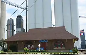 Burlington, Cedar Rapids & Northern Passenger Depot-Dows |
January 7, 1993 (#92001744) |
200 Railroad St. 42°39′28″N 93°29′59″W |
Dows | |
| 3 | Burlington, Cedar Rapids and Northern Railroad Passenger Station | 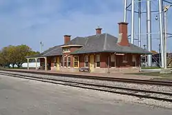 Burlington, Cedar Rapids and Northern Railroad Passenger Station |
June 23, 1988 (#88000926) |
302 S. Main 42°43′48″N 93°43′59″W |
Clarion | |
| 4 | Cornelia Lake Bridge | May 15, 1998 (#98000455) |
Over an inlet of Cornelia Lake 42°47′31″N 93°41′38″W |
Clarion | ||
| 5 | Eagle Grove Public Library | 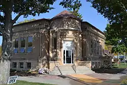 Eagle Grove Public Library |
November 22, 1977 (#77000569) |
401 W. Broadway 42°39′51″N 93°54′24″W |
Eagle Grove | |
| 6 | Fillmore Block | 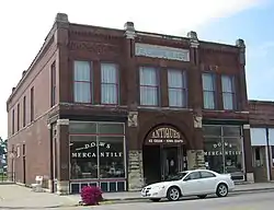 Fillmore Block |
November 20, 1998 (#98001323) |
Junction of Ellsworth and Garfield 42°39′23″N 93°29′59″W |
Dows | |
| 7 | Quasdorf Blacksmith and Wagon Shop | 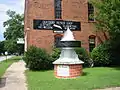 Quasdorf Blacksmith and Wagon Shop |
January 21, 1994 (#93001545) |
Junction of Train and W. Railroad Sts. 42°39′25″N 93°29′57″W |
Dows | |
| 8 | Wright County Courthouse | 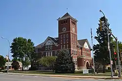 Wright County Courthouse |
July 2, 1981 (#81000277) |
Central Ave. 42°43′56″N 93°43′55″W |
Clarion |
Former listings
| [3] | Name on the Register | Image | Date listed | Date removed | Location | City or town | Summary |
|---|---|---|---|---|---|---|---|
| 1 | Exchange Building | April 12, 1982 (#82002649) | September 23, 1987 | Ellsworth St. |
Dows | ||
| 2 | Goldfield Bridge | 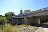 Goldfield Bridge |
May 15, 1998 (#98000456) | September 19, 2019 | Oak St. over the Boone River 42°44′14″N 93°55′29″W |
Goldfield | Replaced in 2004 |
See also
| Wikimedia Commons has media related to National Register of Historic Places in Wright County, Iowa. |
References
- The latitude and longitude information provided in this table was derived originally from the National Register Information System, which has been found to be fairly accurate for about 99% of listings. Some locations in this table may have been corrected to current GPS standards.
- "National Register of Historic Places: Weekly List Actions". National Park Service, United States Department of the Interior. Retrieved on January 29, 2021.
- Numbers represent an alphabetical ordering by significant words. Various colorings, defined here, differentiate National Historic Landmarks and historic districts from other NRHP buildings, structures, sites or objects.
- "National Register Information System". National Register of Historic Places. National Park Service. April 24, 2008.
- The eight-digit number below each date is the number assigned to each location in the National Register Information System database, which can be viewed by clicking the number.
| Topics | |
|---|---|
| Lists by state |
|
| Lists by insular areas | |
| Lists by associated state | |
| Other areas | |
| Related | |
| |

Municipalities and communities of Wright County, Iowa, United States | ||
|---|---|---|
| Cities | Map of Iowa highlighting Wright County | |
| Towns | ||
| Unincorporated communities | ||
| Ghost town | ||
| Footnotes | ‡This populated place also has portions in an adjacent county or counties | |
| ||
This article is issued from Wikipedia. The text is licensed under Creative Commons - Attribution - Sharealike. Additional terms may apply for the media files.