National Register of Historic Places listings in Hardin County, Iowa
This is a list of the National Register of Historic Places listings in Hardin County, Iowa.
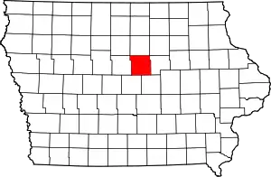
Location of Hardin County in Iowa
This is intended to be a complete list of the properties and districts on the National Register of Historic Places in Hardin County, Iowa, United States. Latitude and longitude coordinates are provided for many National Register properties and districts; these locations may be seen together in a map.[1]
There are 35 properties and districts listed on the National Register in the county.
- This National Park Service list is complete through NPS recent listings posted February 5, 2021.[2]
Current listings
| [3] | Name on the Register[4] | Image | Date listed[5] | Location | City or town | Description |
|---|---|---|---|---|---|---|
| 1 | Alden Bridge | 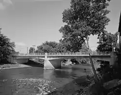 Alden Bridge |
May 15, 1998 (#98000517) |
Main St. over the Iowa River 42°31′16″N 93°22′32″W |
Alden | |
| 2 | Alden Public Library |  Alden Public Library |
March 17, 1981 (#81000241) |
1012 Water St. 42°31′07″N 93°22′01″W |
Alden | |
| 3 | Carnegie-Ellsworth Public Library | 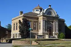 Carnegie-Ellsworth Public Library |
May 23, 1983 (#83000363) |
520 Rocksylvania Ave. 42°31′18″N 93°15′50″W |
Iowa Falls | |
| 4 | Civilian Conservation Corps-Prisoner of War Recreation Hall | 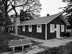 Civilian Conservation Corps-Prisoner of War Recreation Hall |
January 27, 2012 (#11001056) |
301 11th Ave. 42°21′45″N 93°05′11″W |
Eldora | |
| 5 | Edgewood School of Domestic Arts | 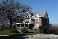 Edgewood School of Domestic Arts |
April 19, 1979 (#79000897) |
719 River St. 42°31′26″N 93°16′06″W |
Iowa Falls | |
| 6 | Eldora Downtown Historic District | 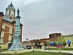 Eldora Downtown Historic District |
May 12, 2009 (#09000297) |
Approximately ten blocks in downtown Eldora around the courthouse square 42°21′37″N 93°05′56″W |
Eldora | |
| 7 | Eldora Public Library | 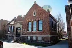 Eldora Public Library |
May 23, 1983 (#83000364) |
1219 14th Ave. 42°21′35″N 93°05′55″W |
Eldora | |
| 8 | Ellsworth-Jones Building | 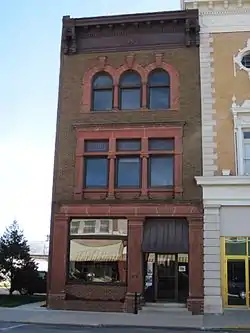 Ellsworth-Jones Building |
October 1, 1993 (#93000959) |
511 Washington Ave. 42°31′10″N 93°15′49″W |
Iowa Falls | |
| 9 | Estes Park Band Shell |  Estes Park Band Shell |
October 1, 1993 (#93000960) |
Estes Park 42°31′15″N 93°15′53″W |
Iowa Falls | |
| 10 | First Congregational Church | 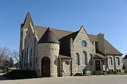 First Congregational Church |
December 4, 1996 (#96001372) |
1209 12th St. 42°21′41″N 93°05′52″W |
Eldora | |
| 11 | First National Bank | 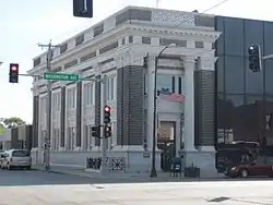 First National Bank |
October 1, 1993 (#93000958) |
601 Washington Ave. 42°31′10″N 93°15′52″W |
Iowa Falls | |
| 12 | Folkert Mound Group |  Folkert Mound Group |
March 17, 2009 (#09000126) |
Address Restricted |
Steamboat Rock | |
| 13 | Hardin County Courthouse | 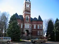 Hardin County Courthouse |
July 2, 1981 (#81000242) |
Edgington Ave. 42°21′32″N 93°05′45″W |
Eldora | |
| 14 | Hardin County Home Historic District | Hardin County Home Historic District |
May 24, 2010 (#10000275) |
28483 County Road D41 42°23′25″N 93°08′18″W |
Eldora | |
| 15 | Honey Creek Friends' Meetinghouse | 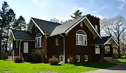 Honey Creek Friends' Meetinghouse |
February 8, 1980 (#80001452) |
Southwest of New Providence 42°15′02″N 93°11′14″W |
New Providence | |
| 16 | Illinois Central Combination Depot-Ackley | 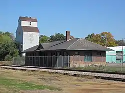 Illinois Central Combination Depot-Ackley |
September 6, 1990 (#90001303) |
North of Railroad St., between State and Mitchell Sts. 42°33′19″N 93°03′08″W |
Ackley | |
| 17 | Iowa Falls Bridge | 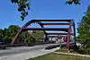 Iowa Falls Bridge |
May 15, 1998 (#98000516) |
U.S. Route 65 over the Iowa River 42°31′06″N 93°15′46″W |
Iowa Falls | Demolished in 2010. |
| 18 | Iowa Falls Union Depot | 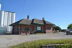 Iowa Falls Union Depot |
September 6, 1990 (#90001305) |
E. Rocksylvania Ave. and Depot St. 42°31′16″N 93°15′23″W |
Iowa Falls | |
| 19 | Glenn and Nell Kurtz Lustron Home and Garage |  Glenn and Nell Kurtz Lustron Home and Garage |
December 2, 2014 (#14000971) |
2017 Washington Ave. 42°31′11″N 93°16′58″W |
Iowa Falls | |
| 20 | McClanahan Block |  McClanahan Block |
October 1, 1993 (#93000956) |
613 Washington Ave. 42°31′10″N 93°15′53″W |
Iowa Falls | |
| 21 | Metropolitan Opera House | 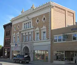 Metropolitan Opera House |
February 20, 1975 (#75000690) |
515 Washington St. 42°30′55″N 93°16′08″W |
Iowa Falls | |
| 22 | Mills Tower Historic District | 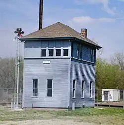 Mills Tower Historic District |
September 6, 1990 (#90001304) |
E. Rocksylvania Ave., 1/3 mile east of Freight House 42°31′22″N 93°14′55″W |
Iowa Falls | |
| 23 | New Providence Building Association Stores | New Providence Building Association Stores |
March 15, 2016 (#16000081) |
401–405 W. Main Street Dr. 42°16′54″N 93°10′19″W |
New Providence | |
| 24 | New Providence School Gymnasium | 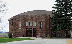 New Providence School Gymnasium |
October 22, 1996 (#96000698) |
106 N. Main St. 42°17′07″N 93°10′22″W |
New Providence | |
| 25 | Princess-Sweet Shop | 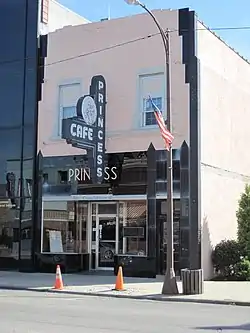 Princess-Sweet Shop |
October 1, 1993 (#93000957) |
607 Washington Ave. 42°31′10″N 93°15′52″W |
Iowa Falls | |
| 26 | River Street Bridge | 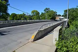 River Street Bridge |
May 15, 1998 (#98000526) |
River St. over the Iowa River 42°31′11″N 93°16′05″W |
Iowa Falls | |
| 27 | St. Matthew's by the Bridge Episcopal Church | 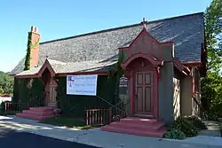 St. Matthew's by the Bridge Episcopal Church |
October 1, 1993 (#93000961) |
Junction of Oak and Railroad Sts. 42°31′06″N 93°15′47″W |
Iowa Falls | |
| 28 | Sentinel Block |  Sentinel Block |
October 1, 1993 (#93000962) |
702 Washington Ave. 42°31′12″N 93°15′56″W |
Iowa Falls | |
| 29 | Slayton Farms-Round Barn |  Slayton Farms-Round Barn |
July 7, 1999 (#99000739) |
20478 135th St. 42°30′52″N 93°17′26″W |
Iowa Falls | |
| 30 | Steamboat Rock Consolidated Schools Building |  Steamboat Rock Consolidated Schools Building |
March 31, 2004 (#04000243) |
306 W. Market St. 42°24′29″N 93°03′55″W |
Steamboat Rock | |
| 31 | Union Cemetery Gardener's Cottage | 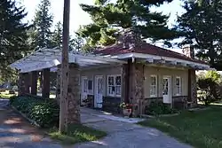 Union Cemetery Gardener's Cottage |
January 24, 2002 (#01001486) |
Union Cemetery 42°31′40″N 93°16′13″W |
Iowa Falls | |
| 32 | US Post Office-Iowa Falls | 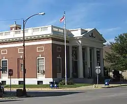 US Post Office-Iowa Falls |
January 5, 1994 (#93000955) |
401 Main St. 42°31′15″N 93°15′56″W |
Iowa Falls | |
| 33 | W.R.C. Hall | 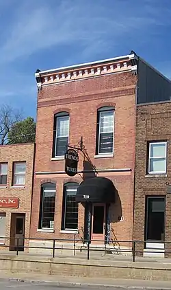 W.R.C. Hall |
October 1, 1993 (#93000963) |
710 Washington Ave. 42°31′11″N 93°15′57″W |
Iowa Falls | |
| 34 | Washington Avenue Bridge | 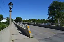 Washington Avenue Bridge |
May 15, 1998 (#98000518) |
U.S. Route 20 over the Iowa River 42°31′11″N 93°16′16″W |
Iowa Falls | |
| 35 | Washington Avenue Commercial Historic District | 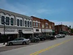 Washington Avenue Commercial Historic District |
October 31, 2012 (#12000889) |
401-714 Washington Ave., the 300 block of Stephens St. and the 200 and 300 blocks of Oak St. 42°31′11″N 93°15′51″W |
Iowa Falls |
See also
| Wikimedia Commons has media related to National Register of Historic Places in Hardin County, Iowa. |
References
- The latitude and longitude information provided in this table was derived originally from the National Register Information System, which has been found to be fairly accurate for about 99% of listings. Some locations in this table may have been corrected to current GPS standards.
- "National Register of Historic Places: Weekly List Actions". National Park Service, United States Department of the Interior. Retrieved on February 5, 2021.
- Numbers represent an alphabetical ordering by significant words. Various colorings, defined here, differentiate National Historic Landmarks and historic districts from other NRHP buildings, structures, sites or objects.
- "National Register Information System". National Register of Historic Places. National Park Service. April 24, 2008.
- The eight-digit number below each date is the number assigned to each location in the National Register Information System database, which can be viewed by clicking the number.
| Topics | |
|---|---|
| Lists by state |
|
| Lists by insular areas | |
| Lists by associated state | |
| Other areas | |
| Related | |
| |

Municipalities and communities of Hardin County, Iowa, United States | ||
|---|---|---|
| Cities | Map of Iowa highlighting Hardin County | |
| Townships | ||
| CDP | ||
| Other unincorporated communities | ||
| Ghost towns | ||
| Footnotes | ‡This populated place also has portions in an adjacent county or counties | |
| ||
This article is issued from Wikipedia. The text is licensed under Creative Commons - Attribution - Sharealike. Additional terms may apply for the media files.