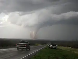
List of United States tornadoes in 2007
This page documents all the tornadoes that touched down in the United States during 2007. Tornadoes in the month of January are given with their Fujita Scale intensity while all tornadoes from February and on are given with their Enhanced Fujita Scale intensity. This is because the scale was changed on February 1 due to the National Weather Service implementing a more accurate way to classify tornadoes.
Confirmed tornadoes
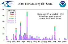
| EFU | EF0 | EF1 | EF2 | EF3 | EF4 | EF5 | Total |
|---|---|---|---|---|---|---|---|
| 0 | 671 | 300 | 91 | 27 | 4 | 1 | 1094 |
|
|
January
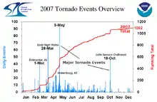
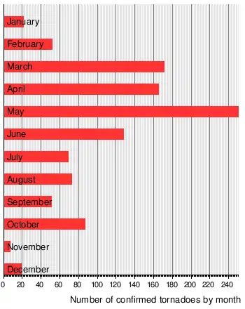
There were 29 tornadoes reported in the US in January, of which 21 were confirmed.
February
87 tornadoes were reported in the US in February, of which 52 were confirmed.
February 1, 2007 also marked the changeover to the Enhanced Fujita Scale.
March
214 tornadoes were reported in the US in March, of which 171 were confirmed.
March 1 event
| List of confirmed tornadoes - Thursday, March 1, 2007 | ||||||
|---|---|---|---|---|---|---|
| Missouri | ||||||
| EF0 | S of Shelbina (1st tornado) | Monroe | 39.52°N 92.22°W | 0730 | 2.1 miles (3.4 km) | Brief touchdown, no damage reported. |
| EF1 | S of Shelbina (2nd tornado) | Monroe | 39.6°N 92.15°W | 0740 | 3.4 miles (5.5 km) | Brief touchdown, no damage reported. |
| EF1 | S of Shelbina (3rd tornado) | Monroe, Shelby | 39.6°N 92.1°W | 0743 | 8.6 miles (13.8 km) | |
| EF3 | SW of Caulfield | Ozark, Howell | 36.59°N 92.15°W | 1224 | 15 miles (24.1 km) | 1 death Long-track tornado in the area. Severe damage was reported to several homes and businesses, including four mobile homes where a first grader died. Tornado just missed a local school. Tornado dissipated just before entering the West Plains city limits. Caused $760,000 in damages. |
| Arkansas | ||||||
| EF0 | SE of Oak Grove | Carroll | 36.42°N 93.39°W | 1028 | 2 miles (3.2 km) | Brief touchdown, caused $10,000 in damages. |
| Louisiana | ||||||
| EF0 | SW of Jonesville | Catahoula | 31.53°N 91.91°W | 1550 | 0.5 miles (0.8 km) | Brief touchdown, no damage reported. |
| Illinois | ||||||
| EF0 | SW of Jonesboro | Union | 37.44°N 89.3°W | 1645 | 1.8 miles (2.9 km) | Brief touchdown, minor damage reported to about 20 houses. Many trees were knocked over. Caused $100,000 in damages. |
| EF0 | Elwin area | Macon | 39.77°N 88.99°W | 1847 | 1 mile (1.6 km) | 1 Injury, Weak tornado caused minor damage to a house and a church. A tree fell on three cars. Caused $40,000 in damages. |
| Florida | ||||||
| EF0 | Spring Hill area | Santa Rosa | 30.77°N 86.94°W | 1720 | 0.5 miles (0.8 km) | Weak tornado briefly touched down in a forest. Trees and power lines knocked down. Caused $10,000 in damages. |
| Mississippi | ||||||
| EF1 | E of Benton | Yazoo | 32.8°N 90.23°W | 1758 | 6.5 miles (10.5 km) | One barn suffered roof damage. Many trees knocked over. Caused $90,000 in damages |
| Alabama | ||||||
| EF0 | W of Industry | Butler | 31.63°N 96.64°W | 1805 | 3.2 miles (5.1 km) | Several trees were blown down and a large truck was blown off Highway 106. Caused $20,000 in damages |
| EF4 | Millers Ferry area | Wilcox, Dallas | 32.12°N 87.41°W | 1827 | 18.3 miles (29.5 km) | 1 death 2 Injuries, Long track tornado devastated a recreational area in the Bill Dannelly Reservoir area. About 70 houses were damaged or destroyed, mostly manufactured homes (one person was killed in one of them even though most were empty), although two wood frame houses were flattened. Some of the debris extended up to 2 miles (3.2 km) away. Caused $2.25 Million in damages |
| EF4 | Enterprise area | Coffee | 31.28°N 85.92°W | 1908 | 10 miles (16.1 km) | 9 deaths 50 Injuries, devastating low-end EF4 tornado that struck Enterprise, Alabama with the most damage at the High School where 8 students were killed. Originally rated a high-end EF3, but a flattened home nearby the school led to its upgrade to an EF4. According to the Red Cross, 239 homes were destroyed, 374 sustained major damage, 529 sustained minor damage, and 251 homes were affected. First killer tornado to hit a school since 1967. Caused $250 Million in damages. |
| EF1 | Echo area | Dale, Henry, Clay (GA), Quitman (GA) | 31.45°N 85.51°W | 1948 | 37.9 miles (61.0 km) | 6 Injuries, Long track tornado with widespread damage to over 70 mobile homes, some of which were destroyed. In addition, five chicken houses were destroyed, killing over 140,000 chickens. Dozens of other houses were damaged. Widespread tree and power line damage also reported. Caused $13.75 Million in damages. |
| EF2 | Letohatchee area | Lowndes, Montgomery | 32.03°N 86.45°W | 2048 | 24.6 miles (39.6 km) | 6 Injuries Large wedge tornado tracked across the area. 39 houses were damaged, three of which were destroyed. Many outbuildings, sheds and silos were also damaged or destroyed, and a power transmission line was knocked down, along with hundreds of trees. Caused $700,000 in damages. |
| EF1 | NW of Fayette | Fayette | 33.81°N 87.9°W | 2059 | 11.2 miles (18.0 km) | Three houses and several sheds suffered minor damage. Widespread tree damage reported. Caused $50,000 in damages. |
| EF1 | N of Samantha | Fayette | 33.43°N 87.64°W | 2100 | 3.7 miles (6.0 km) | Numerous trees were uprooted. One house lost its roof. Initially, NWS officials confirmed two different tornado tracks (including an EF0) but revised as a single tornado following an aerial survey. Caused $50,000 in damages. |
| EF2 | Arley area | Winston, Cullman | 34.08°N 87.25°W | 2145 | 9.6 miles (15.4 km) | Several houses and barns were damaged and a chicken house was destroyed. Caused $50,000 in damages. |
| EF1 | Adamsville area | Jefferson | 33.58°N 86.95°W | 2206 | 0.9 miles (1.4 km) | Tornado reported by The Birmingham News, confirmed by NWS. Major damage to subdivision. Path was 400 yards (360 m) wide at widest point. Dozens of trees uprooted and snapped, one house de-roofed. Caused $100,000 in damages. |
| EF2 | NW of Phenix City | Russell, Lee. Muscogee (GA) | 32.51°N 85.05°W | 2327 | 12.2 miles (19.6 km) | Minor damage in Phenix City, however, considerable damage with many trees and power lines knocked down and structural damage to some houses and businesses in north Columbus, primarily along Brookstone Boulevard. Caused $28.13 Million in damages. |
| EF1 | NNW of Montevallo | Shelby | 33.16°N 86.68°W | 2356 | 0.7 miles (1.1 km) | One house and a barn suffered major damage, primarily due to fallen pine trees. Caused $30,000 in damages. |
| Kentucky | ||||||
| EF1 | Elkton area | Todd | 36.83°N 87.16°W | 2020 | 0.2 miles (0.3 km) | Roofs were blown off two mobile homes and a storage building. Caused $40,000 in damages. |
| Georgia | ||||||
| EF1 | SW of Richland | Stewart | 32.07°N 84.68°W | 2111 | 1.5 miles (2.4 km) | At least 50 houses were damaged to some degree. One house and one church were destroyed. One mobile home was also shifted off its foundation. Caused $400,000 in damages. |
| EF2 | SW of Reynolds | Taylor | 32.49°N 84.16°W | 2229 | 7.7 miles (12.4 km) | 1 Death 4 Injuries, Many houses reported to have been damaged. Many trees and power lines also fell. Caused $500,000 in damages. |
| EF3 | E of Roberta | Crawford, Bibb | 32.72°N 83.93°W | 2234 | 9.7 miles (15.6 km) | 9 Injuries Caused $530,000 in damages. |
| EF1 | NW of Fort Valley | Crawford | 32.61°N 83.97°W | 2249 | 11.9 miles (19.2 km) | Long track tornado, caused $100,000 in damages. |
| EF0 | W of Sherwood Forest | Bibb | 32.87°N 83.81°W | 2251 | 2.6 miles (4.2 km) | Brief touchdown, caused $100,000 in damages. |
| EF1 | NE of Macon | Jones | 32.9°N 83.52°W | 2330 | 3.6 miles (5.8 km) | Extensive damage to trees and power lines. Caused $500,000 in damages. |
| EF0 | SSE of Gray | Jones | 32.99°N 83.41°W | 2330 | 0 | Second tornado from the same cell that produced the first Jones County tornado. Damage limited to a few trees. Caused $10,000 in damages. |
| EF1 | W of Talbotton | Talbot | 32.68°N 84.66°W | 0000 | 4.1 miles (6.6 km) | Minor roof damage to several houses. At least five outbuildings and one mobile home destroyed. Caused $50,000 in damages. |
| EF2 | ENE of Warrenton | Warren, McDuffie | 33.42°N 82.61°W | 0108 | 11.7 miles (18.8 km) | 3 Injuries, Many houses and buildings damaged or destroyed. Severe damage to Briarwood Academy; it was empty at the time. Caused $700,000 in damages. |
| EF3 | Americus area | Webster, Sumter, Macon | 31.92°N 84.55°W | 0200 | 43.2 miles (69.5 km) | 2 Deaths 11 Injuries, Long track, mile-wide tornado caused severe damage to Americus, Georgia, completely destroying the newly built hospital. A total of 75 structures were destroyed, 148 sustained major damage, 331 sustained moderate damage, and 681 sustained minor damage (total of 1,235 structures). Of these, 993 were residences, 217 were businesses, 10 were churches, two were schools, one was a hospital, one was a fire station, eight were recreation facilities/parks, and three were cemeteries. Caused $111.2 Million in damages. |
| EF0 | SW of Allentown | Bleckley | 32.55°N 83.29°W | 0330 | 1.4 miles (2.3 km) | Short-lived tornado destroyed several outbuildings and damaged three houses slightly. Caused $250,000 in damages. |
| EF2 | SE of Irwinton | Wilkinson | 32.66°N 83.15°W | 0340 | 13.3 miles (21.4 km) | Long track, half-mile-wide tornado caused damage to several houses, primarily along SR 112. Caused $30,000 in damages. |
| EF1 | SSW of Junction City | Marion | 32.49°N 84.51°W | 0352 | 2.5 miles (4.0 km) | Brief touchdown, caused $30,000 in damages. |
| EF2 | Newton area | Baker, Mitchell, Dougherty, Worth | 31.32°N 84.45°W | 0444 | 30.5 miles (49.1 km) | 6 Deaths 3 Injuries, Tornado destroyed a mobile home park just north of Newton, where the fatalities took place. At least 100 other houses and 13 businesses were damaged or destroyed along its long path in Baconton and Pleasant Grove as well. Caused $3.97 Million in damages. |
| EF2 | SSW of Sylvester | Worth | 31.44°N 83.89°W | 0520 | 4.6 miles (7.4 km) | 2 Injuries, Related to the Newton tornado. Several houses were destroyed and extensive tree damage was reported. Caused $280,000 in damages. |
| EF2 | NNE of Sumner | Worth | 31.51°N 83.76°W | 0530 | 2.9 miles (4.7 km) | An empty mobile home was destroyed. 24 houses were damaged, some of them heavily. Caused $500,000 in damages. |
| EF1 | N of Chula | Tift, Turner | 31.55°N 83.62°W | 0542 | 7.9 miles (12.7 km) | Extensive damage reported to at least 35 houses and several barns. Widespread tree damage. Caused $1.35 Million in damages. |
March 2 event
| List of confirmed tornadoes - Friday, March 2, 2007 | ||||||
|---|---|---|---|---|---|---|
| Florida | ||||||
| EF0 | SE of Monticello | Jefferson | 30.53°N 83.84°W | 0710 | 2.3 miles (3.7 km) | Brief touchdown, minor roof damage to one house, plus scattered tree damage. Caused $10,000 in damages. |
| EF1 | Cherry Lake area | Madison | 30.58°N 83.43°W | 0736 | 4 miles (6.4 km) | Brief touchdown, one house sustained roof and porch damage. Widespread tree damage was also reported, which also damaged one vehicle. Caused $10,000 in damages. |
| EF0 | E of Live Oak | Suwannee | 30.29°N 82.82°W | 0900 | 0.1 miles (0.2 km) | Brief touchdown, destroyed a garage and damaged many trees and power lines. Caused $10,000 in damages. |
| EF0 | SSE of Callahan | Nassau | 30.53°N 81.8°W | 1025 | 1.2 miles (1.9 km) | Brief touchdown, damage reported to three mobile homes and several sheds. Considerable debris. Caused $30,000 in damages. |
| South Carolina | ||||||
| EF0 | NNE of New Ellenton | Aiken | 33.65°N 81.68°W | 0720 | 4.9 miles (7.9 km) | Brief touchdown, minor damage to two houses, and many trees knocked over. |
| Georgia | ||||||
| EF0 | Lake Park area | Lowndes | 30.67°N 83.2°W | 0755 | 2 miles (3.2 km) | Brief tornado touched down in a RV park. Minor structural damage. Caused $10,000 in damages. |
| North Carolina | ||||||
| EF0 | Smyma area | Carteret | 34.75°N 76.53°W | 1340 | 0.1 miles (0.2 km) | Brief waterspout came ashore, damaging one house. |
March 10 event
| List of confirmed tornadoes - Saturday, March 10, 2007 | ||||||
|---|---|---|---|---|---|---|
| Texas | ||||||
| EF1 | Estelline area | Hall | 34.55°N 100.43°W | 0217 | 0.3 miles (0.5 km) | Brief touchdown, damaged a few trailers. Caused $30,000 in damages. |
March 13 event
| List of confirmed tornadoes - Tuesday, March 13, 2007 | ||||||
|---|---|---|---|---|---|---|
| Texas | ||||||
| EF0 | S of Berclair | Bee | 28.44°N 97.53°W | 0051 | 0.5 miles (0.8 km) | Brief touchdown, no damage reported. |
March 14 event
| List of confirmed tornadoes - Wednesday, March 14, 2007 | ||||||
|---|---|---|---|---|---|---|
| Louisiana | ||||||
| EF0 | Houma area | Terrebonne | 29.6°N 90.72°W | 1350 | 0.2 miles (0.3 km) | Brief touchdown, a few homes damaged as well as power lines down. Caused $10,000 in damages. |
| Ohio | ||||||
| EF0 | Elyria area | Lorain | 41.37°N 82.1°W | 2332 | 2 miles (3.2 km) | Brief touchdown, a few homes damaged and a detached garage which was destroyed. Caused $400,000 in damages. |
March 16 event
| List of confirmed tornadoes - Friday, March 16, 2007 | ||||||
|---|---|---|---|---|---|---|
| Florida | ||||||
| EF0 | E of Bunnell | Flagler | 29.47°N 81.21°W | 1445 | 0 | Very brief touchdown, no damage reported. |
March 21 event
| List of confirmed tornadoes - Wednesday, March 21, 2007 | ||||||
|---|---|---|---|---|---|---|
| Iowa | ||||||
| EF0 | WSW of Seymour | Wayne | 40.62°N 93.31°W | 0539 | 1.4 miles (2.3 km) | Brief touchdown, a few homes damaged. Rated as a high-end EF0. Caused $150,000 in damages. |
March 23 event
| List of confirmed tornadoes - Friday, March 23, 2007 | ||||||
|---|---|---|---|---|---|---|
| New Mexico | ||||||
| EF1 | Logan area | Quay | 35.34°N 103.42°W | 2112 | 2.7 miles (4.3 km) | 12 Injuries Brief touchdown, quarter-mile-wide tornado, several mobile homes were demolished and a roof was torn off a church. Caused $3.5 Million in damages. |
| EF0 | WNW of Lovington | Lea | 32.86°N 103.54°W | 2232 | 3 miles (4.8 km) | Brief touchdown, no damage reported. |
| EF2 | N of McDonald | Lea | 33.13°N 103.45°W | 2307 | 8.4 miles (13.5 km) | Half-mile-wide tornado touchdown, caused $30,000 in damages. |
| EF0 | NW of Tatum (1st tornado) | Lea | 33.4°N 103.33°W | 2336 | 1 mile (1.6 km) | Brief touchdown, no damage reported. |
| EF0 | N of Tatum (2nd tornado) | Lea | 33.49°N 103.37°W | 2345 | 1 mile (1.6 km) | Brief touchdown, no damage reported. |
| EF0 | Rogers area (1st tornado) | Roosevelt | 33.98°N 103.23°W | 0128 | 0.2 miles (0.3 km) | Brief touchdown, no damage reported. |
| EF2 | Rogers area (2nd tornado) | Roosevelt, Curry | 34.24°N 103.17°W | 0130 | 12.5 miles (20.1 km) | 2 Deaths 33 Injuries Long track quarter-mile-wide tornado, several homes and barns destroyed. Caused $19.25 Million in damages. |
| EF0 | E of Lakewood | Eddy | 32.57°N 104.21°W | 0200 | 0.1 miles (0.2 km) | Brief touchdown, no damage reported. |
| Oklahoma | ||||||
| EF0 | SW of Adams | Texas | 36.72°N 101.12°W | 2211 | 1.4 miles (2.3 km) | Brief touchdown, no damage reported. |
| Texas | ||||||
| EF0 | SE of Fort Stockton | Pecos | 30.68°N 102.63°W | 0030 | 2 miles (3.2 km) | Brief touchdown, no damage reported. |
| EF0 | Farwell area | Parmer | 34.37°N 103.03°W | 0159 | 1 mile (1.6 km) | Brief touchdown, no damage reported. |
| EF0 | W of Muleshoe | Bailey | 34.22°N 102.99°W | 0212 | 0.3 miles (0.5 km) | Brief touchdown, caused $10,000 in damages. |
| EF0 | NNE of Rankin | Upton | 31.32°N 101.9°W | 0216 | 2 miles (3.2 km) | Brief touchdown, no damage reported. |
| EF0 | Bovina area | Parmer | 34.52°N 102.9°W | 0238 | 1.8 miles (2.9 km) | Brief touchdown, caused $80,000 in damages. |
| EF0 | SW of Morton (1st tornado) | Cochran | 33.66°N 102.84°W | 0418 | 0.5 miles (0.8 km) | Brief touchdown, caused $80,000 in damages. |
| EF2 | SW of Morton (2nd tornado) | Cochran | 33.72°N 102.84°W | 0422 | 1.5 miles (2.4 km) | Brief touchdown, one structure destroyed and several homes damaged. Caused $180,000 in damages. |
March 24 event
| List of confirmed tornadoes - Saturday, March 24, 2007 | ||||||
|---|---|---|---|---|---|---|
| Texas | ||||||
| EF1 | McLean area | Gray | 35.22°N 100.6°W | 0859 | 2 miles (3.2 km) | Brief touchdown, caused $40,000 in damages. |
| Colorado | ||||||
| EF0 | S of Holyoke (1st tornado) | Yuma | 40.39°N 102.33°W | 2140 | 0.3 miles (0.5 km) | Brief touchdown, no damage reported. |
| EF0 | WNW of Holyoke (2nd tornado) | Phillips | 40.61°N 102.33°W | 2222 | 0.1 miles (0.2 km) | Brief touchdown, no damage reported. |
| EF0 | NE of Amherst | Phillips | 40.74°N 102.17°W | 2255 | 0.1 miles (0.2 km) | Brief touchdown, no damage reported. |
| EF0 | ESE of Julesburg | Sedgwick | 40.95°N 102.07°W | 2335 | 0.1 miles (0.2 km) | Brief touchdown, no damage reported. |
| Nebraska | ||||||
| EF0 | NE of Ogallala | Keith | 41.14°N 101.71°W | 2335 | 0.1 miles (0.2 km) | Brief touchdown, no damage reported. |
| EF0 | N of Big Springs | Deuel | 41.1°N 102.08°W | 2345 | 0.1 miles (0.2 km) | Brief touchdown, no damage reported. |
| EF0 | NE of Hayes Center | Hayes | 40.54°N 100.99°W | 2353 | 0.1 miles (0.2 km) | Brief touchdown, no damage reported. |
March 25 event
| List of confirmed tornadoes - Sunday, March 25, 2007 | ||||||
|---|---|---|---|---|---|---|
| Texas | ||||||
| EF0 | S of Lubbock (1st tornado) | Lubbock | 33.5°N 101.81°W | 1732 | 2 miles (3.2 km) | Brief touchdown, caused $10,000 in damages. |
| EF0 | SSE of Lubbock (2nd tornado) | Lubbock | 33.48°N 101.85°W | 1749 | 2 miles (3.2 km) | Brief touchdown, no damage reported. |
| EF0 | W of Tulia | Swisher | 34.53°N 101.98°W | 2155 | 0.5 miles (0.8 km) | Brief touchdown, no damage reported. |
| EF0 | N of Olton | Castro | 34.38°N 102.24°W | 2200 | 1.3 miles (2.1 km) | Brief touchdown, no damage reported. |
March 26 event
| List of confirmed tornadoes - Monday, March 26, 2007 | ||||||
|---|---|---|---|---|---|---|
| Texas | ||||||
| EF0 | Hondo area (1st tornado) | Medina | 29.35°N 99.12°W | 1920 | 3 miles (4.8 km) | Brief touchdown, no damage reported. |
| EF0 | SE of Hondo | Medina | 29.19°N 98.97°W | 1937 | 0.5 miles (0.8 km) | Brief touchdown, no damage reported. |
| EF0 | Hondo area (2nd tornado) | Medina | 29.35°N 99.18°W | 1945 | 0.5 miles (0.8 km) | Brief touchdown, no damage reported. |
March 27 event
| List of confirmed tornadoes - Tuesday, March 27, 2007 | ||||||
|---|---|---|---|---|---|---|
| Texas | ||||||
| EF1 | SW of Marshall | Harrison | 32.46°N 94.45°W | 1631 | 10 miles (16.1 km) | Damage to many softwood trees. Caused $20,000 in damages. |
| EF0 | E of Scottsville | Harrison | 32.53°N 94.18°W | 1740 | 6 miles (9.7 km) | |
| Arkansas | ||||||
| EF0 | NW of Lewisville | Lafayette, Hempstead | 33.42°N 93.67°W | 1914 | 5 miles (8.0 km) | Several homes and a chicken house were damaged. Caused $80,000 in damages. |
| Louisiana | ||||||
| EF1 | NE of Sparta | Webster | 32.9°N 93.32°W | 1935 | 8 miles (12.9 km) | Caused $30,000 in damages. |
March 28 event
| List of confirmed tornadoes - Wednesday, March 28, 2007 | ||||||
|---|---|---|---|---|---|---|
| Illinois | ||||||
| EF0 | N of Atlanta | Logan | 40.28°N 89.23°W | 2005 | 0.1 miles (0.2 km) | Brief touchdown, no damage reported. |
| EF0 | SW of McLean | McLean | 40.3°N 89.2°W | 2019 | 0.1 miles (0.2 km) | Brief touchdown, no damage reported. |
| Texas | ||||||
| EF0 | Silverton area (1st tornado) | Swisher, Briscoe | 34.28°N 101.5°W | 2220 | 2.5 miles (4.0 km) | Brief touchdown, no damage reported. |
| EF0 | SW of Silverton (2nd tornado) | Briscoe | 34.37°N 101.42°W | 2228 | 2 miles (3.2 km) | Brief touchdown, no damage reported. |
| EF1 | S of Silverton (3rd tornado) | Briscoe | 34.45°N 101.36°W | 2248 | 6.8 miles (10.9 km) | Caused $40,000 in damages. |
| EF0 | SE of South Plains | Floyd | 34.25°N 101.32°W | 2303 | 0.5 miles (0.8 km) | Brief touchdown, caused $10,000. |
| EF0 | NE of Silverton (4th tornado) | Briscoe | 34.54°N 101.22°W | 2303 | 4.8 miles (7.7 km) | Brief touchdown, no damage reported. |
| EF0 | NE of Silverton (5th tornado) | Briscoe | 34.67°N 101.2°W | 2310 | 1.8 miles (2.9 km) | Brief touchdown, no damage reported. |
| EF2 | N of Quitaque | Briscoe, Hall, Donley | 34.5°N 101.5°W | 2335 | 23.8 miles (38.3 km) | Long track quarter-mile-wide tornado, caused $180,000 in damages. |
| EF0 | SW of Clarendon | Donley | 34.8°N 101.06°W | 2340 | 1 mile (1.6 km) | Brief touchdown, no damage reported. |
| EF0 | SSW of Clarendon | Donley | 34.77°N 100.98°W | 0005 | 1 mile (1.6 km) | Brief touchdown, no damage reported. |
| EF2 | Brooker area | Lipscomb, Beaver (OK) | 36.45°N 100.44°W | 0016 | 22 miles (35.4 km) | 2 deaths Widespread debris and damage reported. Long track tornado, caused $100,000 in damages. |
| EF3 | Jericho area (1st tornado) | Donley, Gray | 35.13°N 100.94°W | 0039 | 6.4 miles (10.3 km) | 4 Injuries Several tractor-trailers flipped on Interstate 40 several houses were damaged and barns were destroyed as well. Originally rated as an EF2 but was later upgraded to an EF3. Caused $280,000 in damages. |
| EF2 | SW of Amarillo | Donley | 34.93°N 100.74°W | 0046 | 4.2 miles (6.8 km) | Heavy tree damage, and one barn was destroyed. Several other outbuildings were damaged, caused $60,000 in damages. |
| EF0 | N of Hedley | Donley | 35.03°N 100.67°W | 0102 | 0.3 miles (0.5 km) | Brief touchdown, no damage reported. |
| EF2 | McLean area (1st tornado) | Donley | 35.12°N 100.78°W | 0113 | 4.5 miles (7.2 km) | Heavy damage to several houses. Major tree and power line damage. Caused $170,000 in damages. |
| EF0 | SE of Jericho (2nd tornado) | Donley | 35.09°N 100.68°W | 0115 | 1 mile (1.6 km) | Brief touchdown, no damage reported. |
| EF2 | McLean area (2nd tornado) | Gray | 35.21°N 100.58°W | 0123 | 3.6 miles (5.8 km) | Mesonet weather station reported 127 mph (205 km/h) winds. Heavy damage to several houses and barns. Caused $70,000 in damages. |
| EF0 | Lefors area (1st tornado) | Gray | 35.42°N 100.81°W | 0130 | 0.3 miles (0.5 km) | Brief touchdown, no damage reported. |
| EF1 | Lefors area (2nd tornado) | Gray | 35.44°N 100.81°W | 0136 | 0.3 miles (0.5 km) | Brief touchdown, caused $40,000 in damages. |
| EF3 | E of McLean (3rd tornado) | Gray | 35.32°N 100.55°W | 0145 | 8 miles (12.9 km) | Enormous tornado, 1 mile (1.6 km) in width, that fortunately remained mostly in rural countryside. Only one house affected with moderate damage. Many trees debarked and severe power line damage. Caused $30,000 in damages. |
| EF3 | W of Canadian | Hemphill | 35.69°N 100.49°W | 0230 | 7.8 miles (12.6 km) | 1 Death 1 Injury Large 3/4-mile-wide tornado caused enormous damage to several mobile homes and destroyed several oil rigs. Caused $3 Million in damages. |
| Kansas | ||||||
| EF0 | SE of Sharon Springs (1st tornado) | Wallace | 38.85°N 101.72°W | 2349 | 0.5 miles (0.8 km) | Brief touchdown, no damage reported. |
| EF0 | SE of Sharon Springs (2nd tornado) | Wallace | 38.88°N 101.73°W | 2352 | 6 miles (9.7 km) | |
| EF0 | Jennings area | Decatur | 39.62°N 100.2°W | 0005 | 8 miles (12.9 km) | Caused $40,000 in damages. |
| EF0 | SE of Meade (1st tornado) | Meade | 37.25°N 100.29°W | 0028 | 1.4 miles (2.3 km) | Brief touchdown, no damage reported. |
| EF0 | NE of Meade (2nd tornado) | Meade | 37.33°N 100.27°W | 0032 | 1.3 miles (2.1 km) | Brief touchdown, no damage reported. |
| EF0 | NE of Coolridge | Sherman, Greeley | 38.12°N 101.88°W | 0033 | 21.6 miles (34.8 km) | Long track tornado, no damage reported. |
| EF0 | Goodland area (1st tornado) | Sherman | 39.2°N 101.64°W | 0037 | 0.5 miles (0.8 km) | Brief touchdown, no damage reported. |
| EF1 | S of Ensign (1st tornado) | Meade, Gray | 37.38°N 100.25°W | 0042 | 13.5 miles (21.7 km) | Long track tornado, caused $80,000 in damages. |
| EF0 | SE of Goodland (2nd tornado) | Sherman | 39.3°N 101.65°W | 0049 | 0.5 miles (0.8 km) | Brief touchdown, no damage reported. |
| EF0 | S of Howell (1st tornado) | Ford | 37.63°N 100.18°W | 0058 | 7.8 miles (12.6 km) | |
| EF0 | N of Edson (1st tornado) | Sherman | 39.36°N 101.55°W | 0106 | 3 miles (4.8 km) | Brief touchdown, no damage reported. |
| EF1 | NW of Tribune | Greeley, Wallace | 38.44°N 101.84°W | 0109 | 23 miles (37.0 km) | Long track tornado, upgraded to an EF1 in the final review of 2007. Caused $280,000 in damages. |
| EF1 | NW of Ensign (2nd tornado) | Gray | 37.67°N 100.25°W | 0114 | 10.4 miles (16.7 km) | Caused $160,000 in damages. |
| EF2 | Bird City area (1st tornado) | Sherman, Cheyenne | 39.48°N 101.55°W | 0115 | 34 miles (54.7 km) | Long track, large wedge tornado. Widespread power flashes reported and extensive damage. Tornado missed the village but affected a number of houses. Caused $2.1 Million in damages. |
| EF1 | N of Howell (2nd tornado) | Ford, Hodgeman | 37.9°N 100.15°W | 0132 | 10.7 miles (17.2 km) | |
| EF0 | SE of Meade (3rd tornado) | Meade | 37°N 100.27°W | 0139 | 8.7 miles (14.0 km) | |
| EF1 | E of Bird City (2nd tornado) | Cheyenne | 39.75°N 101.45°W | 0149 | 4 miles (6.4 km) | Caused $10,000 in damages. |
| EF3 | Jetmore area | Hodgeman, Ness | 38.08°N 100.07°W | 0201 | 29.1 miles (46.8 km) | Large 3/4 mile-wide tornado killed approximately 50 head of cattle and threw a 5-ton tank 1 mile. Caused $540,000 in damages. |
| EF1 | Benkelman area | Cheyenne, Dundy (NE) | 39.91°N 101.44°W | 0209 | 15 miles (24.1 km) | Quarter-mile-wide tornado damaged several houses. Caused $490,000 in damages. |
| EF0 | E of Edson (2nd tornado) | Sherman | 39.33°N 101.48°W | 0229 | 2.5 miles (4.0 km) | Brief touchdown, no damage reported. |
| EF0 | WNW of Tribune | Greeley | 38.56°N 102.4°W | 0251 | 7 miles (11.3 km) | |
| EF0 | NE of Edson (3rd tornado) | Sherman | 39.37°N 101.5°W | 0254 | 0.5 miles (0.8 km) | Brief touchdown, no damage reported. |
| EF0 | Weskan area | Wallace | 38.8°N 101.97°W | 0309 | 0.5 miles (0.8 km) | Brief touchdown, no damage reported. |
| EF0 | SE of Bird City (3rd tornado) | Cheyenne | 39.74°N 101.52°W | 0324 | 2 miles (3.2 km) | Brief touchdown, no damage reported. |
| Nebraska | ||||||
| EF0 | 20 S of Merriman | Cherry | 42.52°N 101.93°W | 0012 | 3 miles (4.8 km) | Brief touchdown, no damage reported. |
| EF0 | NW of Imperial | Chase | 40.66°N 101.82°W | 0105 | 0.1 miles (0.2 km) | Brief touchdown, no damage reported. |
| EF1 | W of Arthur | Arthur | 41.41°N 101.92°W | 0105 | 20.6 miles (33.2 km) | Long track tornado |
| EF1 | NE of Lamar | Chase, Perkins | 40.69°N 101.82°W | 0111 | 2.5 miles (4.0 km) | Brief touchdown, caused $20,000 in damages. |
| EF0 | SE of Brandon (1st tornado) | Perkins | 40.71°N 101.76°W | 0112 | 0.2 miles (0.3 km) | Brief touchdown, no damage reported. |
| EF1 | SE of Brandon (2nd tornado) | Perkins | 40.76°N 101.78°W | 0120 | 2.3 miles (3.7 km) | Brief touchdown, caused $20,000 in damages. |
| EF2 | Grant area | Perkins | 40.76°N 101.77°W | 0120 | 15.9 miles (25.6 km) | Half-mile-wide tornado damaged outbuildings and destroyed one home, caused $1.2 Million in damages. |
| EF1 | S of Ashby | Grant | 41.88°N 101.92°W | 0146 | 2 miles (3.2 km) | Power lines, trees and fences were damaged and equipment was moved. |
| EF0 | NW of Ogallala (1st tornado) | Keith | 41.05°N 101.85°W | 0200 | 0.1 miles (0.2 km) | Brief touchdown, no damage reported. |
| EF1 | SW of Ogallala (2nd tornado) | Keith | 41.12°N 101.75°W | 0211 | 0.7 miles (1.1 km) | Tornado destroyed outbuildings, damaged cattle pens, and moved irrigation pipes at stockyards west of Ogallala, caused $100,000 in damages. |
| EF0 | N of Ogallala (3rd tornado) | Keith | 41.19°N 101.71°W | 0220 | 0.7 miles (1.1 km) | Minor damage to homes and tree limbs, caused $10,000 in damages. |
| Oklahoma | ||||||
| EF2 | E of Beaver | Beaver | 36.73°N 100.41°W | 0104 | 6 miles (9.7 km) | Trailers were destroyed as they thrown some distance away and a large silo was toppled, caused $60,000 in damages. |
| Colorado | ||||||
| EF3 | Holly area | Prowers, Kiowa | 38.02°N 102.12°W | 0154 | 28 miles (45.1 km) | 2 Deaths 9 Injuries Long-track, half-mile-wide tornado destroyed five homes and damaged at least 60 others and one house was nearly flattened, caused $4.01 Million in damages. |
| EF1 | E of Towner | Kiowa, Greeley (KS) | 38.46°N 102.05°W | 0240 | 11.6 miles (18.7 km) | Long-track tornado, no damage reported |
March 29 event
| List of confirmed tornadoes - Thursday, March 29, 2007 | ||||||
|---|---|---|---|---|---|---|
| Oklahoma | ||||||
| EF1 | ESE of Okeene | Blaine | 36.1°N 98.36°W | 2005 | 2.3 miles (3.7 km) | Some damage to garages, barns, grain bins and silos, caused $50,000 in damages. |
| EF2 | Piedmont area | Canadian | 35.5°N 97.71°W | 2105 | 7.5 miles (12.1 km) | 5 Injuries Widespread structural damage reported in the northwest metropolitan area of Oklahoma City. Numerous mobile homes were destroyed and at least 10 cars were flipped on the Kilpatrick Turnpike according to KOCO coverage and a landing Gulfstream jet was forced off the runway at Wiley Post Airport according to KWTV coverage. caused $500,000 in damages. |
| EF0 | W of Hillsdale | Garfield, Grant | 36.57°N 98.03°W | 2120 | 3 miles (4.8 km) | Some damage to garages, barns, grain bins and silos, caused $30,000 in damages. |
March 30 event
| List of confirmed tornadoes - Friday, March 30, 2007 | ||||||
|---|---|---|---|---|---|---|
| Texas | ||||||
| EF0 | NW of Wimberly | Hays | 30.14°N 98.22°W | 1503 | 0.2 miles (0.3 km) | Brief touchdown, no damage reported. |
| EF0 | SW of Dripping Springs | Hays | 30.12°N 98.17°W | 1525 | 0.3 miles (0.5 km) | Brief touchdown, no damage reported. |
| EF0 | S of Carbon | Eastland | 32.24°N 98.83°W | 1620 | 1 mile (1.6 km) | Brief touchdown, no damage reported. |
| EF0 | E of Sweetwater | Nolan, Fisher | 32.47°N 100.21°W | 1702 | 7.2 miles (11.6 km) | 1 Injury Tornado turned over a tractor trailer rig, injuring the driver. Caused $10,000 in damages. |
| EF0 | WNW of Huckabay | Erath | 32.38°N 98.44°W | 1743 | 1 mile (1.6 km) | Brief touchdown, no damage reported. |
| EF0 | Aaf Ft Hoo area | Bell | 31.1°N 97.86°W | 2055 | 2.5 miles (4.0 km) | Tornado struck the Aaf Ft Hoo military base, no damage was reported. |
| EF1 | SW of Oglesby | Coryell | 31.35°N 97.6°W | 2136 | 3.1 miles (5.0 km) | Tornado damaged a few barns and two houses. Caused $40,000 in damages. |
| EF1 | SW of McGregor | McLennan | 31.42°N 97.44°W | 2140 | 2 miles (3.2 km) | Tornado destroyed the back half of a rodeo arena. Caused $500,000 in damages. |
| EF0 | Riesel area | McLennan | 31.48°N 96.93°W | 2300 | 0.5 miles (0.8 km) | Brief touchdown, no damage reported. |
| EF1 | Wylie area | Collin | 33.02°N 96.55°W | 0220 | 0.8 miles (1.3 km) | Brief touchdown, 25 to 30 homes suffered severe damage to roofs and garage doors. Several other homes suffered minor damage such as broken fences and windows. The tornado had winds estimated at 95 mph. Caused $500,000 in damages. |
| Kansas | ||||||
| EF0 | ENE of Council Grove | Morris | 38.68°N 96.39°W | 0248 | 2.8 miles (4.5 km) | Brief touchdown, no damage reported. |
| EF0 | SW of Clinton | Douglas | 38.86°N 95.46°W | 0339 | 2 miles (3.2 km) | Brief touchdown, no damage reported. |
March 31 event
| List of confirmed tornadoes - Saturday, March 31, 2007 | ||||||
|---|---|---|---|---|---|---|
| Texas | ||||||
| EF1 | S of Halletsville (1st tornado) | Lavaca | 29.39°N 96.95°W | 0930 | 0.8 miles (1.3 km) | Brief touchdown, one barn was destroyed and moved a mobile home a couple yards. Caused $100,000 in damages. |
| EF2 | SE of Halletsville (2nd tornado) | Lavaca | 29.39°N 96.88°W | 0945 | 0.4 miles (0.6 km) | 4 Injuries Brief touchdown, tornado completely destroyed a mobile home and threw the four occupants, a father and his three children, 150 from where the mobile home was. The tornado had winds estimated at 115 mph due to the metal remains of the mobile home being twisted. Caused $80,000 in damages. |
| Nebraska | ||||||
| EF1 | W of Herman | Washington | 41.67°N 96.56°W | 1935 | 1 mile (1.6 km) | Brief touchdown, a horse barn was almost completely destroyed and several sheds were damaged. Caused $20,000 in damages. |
| Iowa | ||||||
| EF0 | NW of Oelwein | Fayette | 41.27°N 91.93°W | 2158 | 0.3 miles (0.5 km) | A tornado touched down briefly on a farm near Oelwein, destroying a 100-year-old barn. A garage, machine shed, windmill and a few trees were damaged. Caused $10,000 in damages |
| EF1 | N of Delaware | Delaware, Clayton | 42.55°N 91.35°W | 2229 | 11.9 miles (19.2 km) | A tornado destroyed a dairy farm and damaged eight other barns. A two car garage was completely destroyed as well. Twenty-four cows were killed when the dairy farm collapsed. Caused $200,000 in damages |
| Missouri | ||||||
| EF0 | S of St. Louis | St. Louis | 38.61°N 90.25°W | 2250 | 1.7 miles (2.7 km) | 2 Injuries A tornado touched down briefly to the south of St. Louis without causing damage. |
| Wisconsin | ||||||
| EF0 | ENE of Potosi | Grant | 42.69°N 90.68°W | 2318 | 0.3 miles (0.5 km) | Brief touchdown, caused minor damages to a few homes. Caused $10,000 in damages. |
April
There were 187 tornadoes were reported in the US in April, of which 167 were confirmed.
May
There were 282 tornadoes were reported in the US in May, of which 251 were confirmed.
May 1 event
| List of confirmed tornadoes - Tuesday, May 1, 2007 | ||||||
|---|---|---|---|---|---|---|
| Kansas | ||||||
| EF0 | N of Alma | Wabaunsee | 39.03°N 96.28°W | 1850 | 0.1 miles (0.2 km) | Brief touchdown, damage reported |
| EF0 | W of Fowler | Meade | 37.38°N 100.21°W | 1920 | 0.2 miles (0.3 km) | Brief touchdown, damage reported |
| EF0 | Maple Hill area | Wabaunsee | 39.08°N 96.03°W | 2007 | 0.1 miles (0.2 km) | Brief touchdown, no damage reported |
| EF0 | SE of Maple Hill | Wabaunsee | 39.04°N 95.98°W | 2017 | 0.1 miles (0.2 km) | Brief touchdown, damage reported |
| Ohio | ||||||
| EF0 | N of Portage | Wood | 41.33°N 83.65°W | 1950 | 0.3 miles (0.5 km) | Brief touchdown. Caused $1,000 in crop losses. |
| Texas | ||||||
| EF0 | W of Brady Curtis Rnch Ar (1st tornado) | McCulloch | 31.32°N 99.31°W | 2005 | 3.3 miles (5.3 km) | Tornado caused minor damages to wheat crops. Caused $5,000 in crop losses. |
| EF0 | SSW of Brady Curtis Rnch Ar (2nd tornado) | McCulloch | 31.28°N 99.25°W | 2035 | 1.8 miles (2.9 km) | Brief touchdown, no damage reported. |
| EF0 | N of Harper | McCulloch | 30.31°N 99.25°W | 0040 | 0.2 miles (0.3 km) | Brief touchdown, no damage reported. |
| Pennsylvania | ||||||
| EF1 | SE of Meadville | Crawford | 41.6°N 80.11°W | 2205 | 2 miles (3.2 km) | Brief touchdown, ten structures were damaged and several hundred trees were knocked down. Caused $500,000 in damages. |
| EF0 | N of Mercer | Mercer | 41.24°N 80.23°W | 2215 | 4 miles (6.4 km) | Brief touchdown, one barn was destroyed and two trees fell onto mobile homes, causing significant damage. Caused $20,000 in damages. |
May 2 event
| List of confirmed tornadoes - Wednesday, May 2, 2007 | ||||||
|---|---|---|---|---|---|---|
| Texas | ||||||
| EF0 | WSW of Sterling City | Sterling | 31.76°N 101.19°W | 1720 | 0.6 miles (1.0 km) | Brief touchdown, no damage reported |
| EF0 | NW of Orient | Tom Green, Coke | 31.68°N 100.37°W | 1835 | 6.4 miles (10.3 km) | Damage was confined to trees. |
| EF0 | E of Maverick | Runnels | 31.83°N 100.19°W | 1908 | 0.5 miles (0.8 km) | Brief touchdown, tornado destroyed a barn. Caused $8,000 in damages. |
| EF1 | WNW of Rockwood | Coleman | 31.51°N 99.42°W | 2020 | 5.7 miles (9.2 km) | Tornado damaged several buildings including a post office. Caused $100,000 in damages |
| EF1 | ENE of Brookesmith | Brown | 31.56°N 99.09°W | 2048 | 4.8 miles (7.7 km) | Tornado caused significant tree damage. Caused $10,000 in damages. |
| EF0 | Cleburne area | Johnson | 32.35°N 97.4°W | 2211 | 0.2 miles (0.3 km) | Brief touchdown, no damage reported. |
| New Mexico | ||||||
| EF0 | S of Condron Airport | Doña Ana, Otero | 32.2°N 106.43°W | 1848 | 8.4 miles (13.5 km) | Unusually long lived and large landspout. The landspout was on the ground for 52 minutes and could be seen from 30 miles away. |
| EF0 | WSW of Dunes | Otero | 32.2°N 106.43°W | 1945 | 0.6 miles (1.0 km) | Brief touchdown, no damage reported. |
May 3 event
| List of confirmed tornadoes - Thursday, May 3, 2007 | ||||||
|---|---|---|---|---|---|---|
| Missouri | ||||||
| EF0 | SE of Dexter | Stoddard | 36.75°N 89.89°W | 2128 | 3.5 miles (5.6 km) | Tornado remained in open field. |
| Louisiana | ||||||
| EF1 | WNW of Beekman | Morehouse | 32.94°N 91.95°W | 2147 | 2 miles (3.2 km) | Brief touchdown, tornado tore the roof off of one home. Caused $120,000 in damages. |
| EF1 | NE of Bastrop | Morehouse | 32.84°N 91.83°W | 2151 | 0.5 miles (0.8 km) | Brief touchdown, tornado struck the Log Cabbin Community and severely damaged one home. Caused $80,000 in damages. |
| Texas | ||||||
| EF0 | W of Livingston | Polk | 30.7°N 94.96°W | 2150 | 0.3 miles (0.5 km) | Brief touchdown, no damage reported. |
| EF0 | New Caney area | Montgomery | 30.15°N 95.2°W | 2230 | 0.9 miles (1.4 km) | Brief touchdown, caused minor damage to a few homes. Caused $30,000 in damages |
| EF0 | N of Lindsay | Cooke | 33.67°N 97.23°W | 0040 | 0.5 miles (0.8 km) | Brief touchdown, no damage reported. |
| Arkansas | ||||||
| EF1 | SE of Fountain Hill | Ashley | 33.3°N 91.82°W | 2218 | 5 miles (8.0 km) | Tornado tore part of the roof of a church off and destroyed several outbuildings. Caused $500,000 in damages. |
| Colorado | ||||||
| EF0 | SW of Pierce | Weld | 40.61°N 104.78°W | 2329 | 0.1 miles (0.2 km) | Brief touchdown, no damage reported. |
| EF0 | W of Purcell | Weld | 40.63°N 104.59°W | 2358 | 0.1 miles (0.2 km) | Brief touchdown, no damage reported. |
| EF0 | ESE of Barnesville | Weld | 40.45°N 104.42°W | 0016 | 0.1 miles (0.2 km) | Brief touchdown, no damage reported. |
| EF0 | S of Alden | Weld | 40.39°N 104.56°W | 0021 | 0.1 miles (0.2 km) | Brief touchdown, no damage reported. |
| EF0 | E of Buckingham | Weld | 40.61°N 103.9°W | 0150 | 0.1 miles (0.2 km) | Brief touchdown, no damage reported. |
| EF0 | NNE of Narrows | Morgan | 40.35°N 103.88°W | 0220 | 0.1 miles (0.2 km) | Brief touchdown, no damage reported. |
May 4 event
| List of confirmed tornadoes - Friday, May 4, 2007 | ||||||
|---|---|---|---|---|---|---|
| Illinois | ||||||
| EF0 | W of Gillespie | Macoupin | 39.13°N 89.92°W | 2204 | 0 miles (0.0 km) | Brief touchdown, no damage reported. |
| EF0 | E of Wood River | Madison | 38.85°N 90.02°W | 2250 | 0 miles (0.0 km) | Brief touchdown, no damage reported. |
| EF0 | NE of Shipman | Macoupin | 39.14°N 90.02°W | 2305 | 0 miles (0.0 km) | Brief touchdown, no damage reported. |
June
There were 152 tornadoes were reported in the US in June, of which 128 were confirmed.
June 1st
A full scale EF3 formed in Grandview.
It went through Fruitland and over the hill reaching muscatine.
This tornado was the massive supertwister that destroyed houses and damaged several mobile homes and trailers.
July
There were 55 tornadoes were reported in the U.S. in July, however 69 were confirmed.
August
There were 87 tornadoes were reported in the US in August, of which 73 were confirmed.
August 2 event
| List of confirmed tornadoes - Thursday, August 2, 2007 | ||||||
|---|---|---|---|---|---|---|
| Texas | ||||||
| EF0 | WNW of New Home | Lynn | 33.37°N 102.06°W | 1851 | 0.3 miles (0.5 km) | Brief touchdown, no damage reported |
August 3 event
| List of confirmed tornadoes - Friday, August 3, 2007 | ||||||
|---|---|---|---|---|---|---|
| South Dakota | ||||||
| EF0 | SSE of St. Francis | Todd | 42.99°N 100.84°W | 2230 | 0 miles (0.0 km) | Brief touchdown, no damage reported |
| Nebraska | ||||||
| EF0 | N of Sparks | Cherry | 42.98°N 100.27°W | 0002 | 0.1 miles (0.2 km) | Brief touchdown, no damage reported |
| EF0 | N of Bartlett | Wheeler | 41.97°N 98.55°W | 0130 | 0.1 miles (0.2 km) | Brief touchdown, no damage reported |
August 5 event
| List of confirmed tornadoes - Sunday, August 5, 2007 | ||||||
|---|---|---|---|---|---|---|
| Illinois | ||||||
| EF0 | Bolingbrook area | Will | 41.67°N 88.13°W | 2313 | 0.4 miles (0.6 km) | Brief touchdown, a construction trailer was flipped over and shingles were blown off a barn. Caused $40,000 in damages. |
| Ohio | ||||||
| EF0 | SW of Bettsville | Seneca | 41.22°N 83.27°W | 2313 | 0.8 miles (1.3 km) | Brief touchdown, The tornado damaged a metal building and a gazebo a farm. The barn had one wall completely blown out. Caused $60,000 in damages. |
| EF0 | S of Carey | Wyandot | 40.94°N 83.37°W | 2313 | 0.8 miles (1.3 km) | Brief touchdown, The tornado damaged a couple of homes and destroyed at least two barns. Caused $75,000 in damages |
August 8 event
| List of confirmed tornadoes - Wednesday, August 8, 2007 | ||||||
|---|---|---|---|---|---|---|
| New York | ||||||
| EF1 | Staten Island area | Richmond | 26.39°N 97.77°W | 1022 | 2 miles (3.2 km) | The first of two early morning tornadoes to strike near New York City. According to the National Weather Service, the tornado first touched down in Staten Island at approximately 6:22 am EST in the vicinity of St. Austins Place in the Livingston - Randall Manor area, before moving east, with additional damage occurring in the Tompkinsville area. Most of the damage in Staten Island was to trees. Damage is unknown. |
| EF2 | Brooklyn area | Kings | 40.63°N 74.11°W | 1032 | 5.9 miles (9.5 km) | 9 Injuries The second of two early morning tornadoes to strike near New York City. The tornado touched down near The Narrows tidal strait, just north of the Verrazano-Narrows Bridge, in Brooklyn, at Bay Ridge at 6:32 am EST. It continued on an east-northeast path across 68th Street between Third and Fourth Avenues, damaging the roofs of 11 homes. The storm continued to move east-northeast into Leif Ericson Park Square, where severe damage to trees occurred, and where winds blew out a 15-foot-tall (4.6 m) stained glass window valued at $300,000 at the nearby Fourth Avenue Presbyterian Church. It then crossed the Brooklyn Queens Expressway. The tornado touched down farther northeast with scattered tree damage along Sixth Avenue. Damage from the tornado is estimated at $20 million. |
| South Dakota | ||||||
| EF0 | NW of Eureka | McPherson | 45.78°N 99.64°W | 2059 | 0.2 miles (0.3 km) | Brief touchdown, no damage reported |
| Missouri | ||||||
| EF0 | S of Durham | Lewis | 39.96°N 91.67°W | 2202 | 0.1 miles (0.2 km) | Brief touchdown, no damage reported |
| EF0 | NNW of Fairfax | Atchison | 40.35°N 95.41°W | 2345 | 0.1 miles (0.2 km) | Brief touchdown, no damage reported |
August 16 event
| List of confirmed tornadoes - Thursday, August 16, 2007 | ||||||
|---|---|---|---|---|---|---|
| Texas | ||||||
| EF1 | N of Boerne | Kendall | 29.91°N 98.73°W | 2253 | 0.5 miles (0.8 km) | Brief touchdown, tornado struck a small building and caused minor damage before lifting and dissipating. Caused $10,000 in damages |
August 17 event
| List of confirmed tornadoes - Thursday, August 16, 2007 | ||||||
|---|---|---|---|---|---|---|
| Idaho | ||||||
| EF0 | NE of Inkhom | Bannock | 42.83°N 112.21°W | 2222 | 0.2 miles (0.3 km) | Brief touchdown, five large cottonwood and birch trees snapped with residence fence destroyed. Caused $1,000 in damages |
August 18 event
| List of confirmed tornadoes - Saturday, August 18, 2007 | ||||||
|---|---|---|---|---|---|---|
| Colorado | ||||||
| EF0 | NW of Idaho | Clear Creek | 39.8°N 105.59°W | 2010 | 0.1 miles (0.2 km) | Brief touchdown, one tree was snapped but no other damage was reported. |
| Oklahoma | ||||||
| EF1 | ESE of Hobart | Kiowa | 34.99°N 99.01°W | 2146 | 6 miles (9.7 km) | Tornado destroyed a large barn, and damaged power lines, numerous trees and farm implements. Caused $50,000 in damages |
| EF0 | ESE of Cordell | Washita | 35.17°N 98.91°W | 2210 | 4 miles (6.4 km) | Tornado was on the ground for 10 minutes but caused no damage. |
| EF1 | SSW of Norge | Grady | 34.95°N 98.01°W | 0144 | 2 miles (3.2 km) | Brief touchdown, tornado damaged a mobile home and several trees were snapped. Caused $15,000 in damages |
| Texas | ||||||
| EF1 | NNE of Thornberry | Clay | 34.08°N 98.37°W | 0053 | 1 mile (1.6 km) | Brief touchdown, several large pecan trees were snapped. Caused $10,000 in damages |
August 19 event
| List of confirmed tornadoes - Sunday, August 19, 2007 | ||||||
|---|---|---|---|---|---|---|
| Oklahoma | ||||||
| EF0 | ENE of Cogar | Caddo, Canadian | 35.34°N 98.1°W | 0700 | 3 miles (4.8 km) | Damage confined to snapped trees. Caused $10,000 in damages |
| EF1 | Minco area | Grady, Canadian | 35.31°N 97.91°W | 0700 | 7 miles (11.3 km) | Four mobile homes were damaged, one significantly. Caused $50,000 in damages |
September
There were 63 tornadoes were reported in the US in September, of which 51 were confirmed.
September 13
| List of confirmed tornadoes - Thursday, September 13, 2007 | ||||||
|---|---|---|---|---|---|---|
| Louisiana | ||||||
| EF1 | WNW of Haire | Vermilion | 30.03°N 92.42°W | 2024 | 0.3 miles (0.5 km) | Brief touchdown, the roof was blown off of one home and downed trees and power lines. Caused $25,000 in damages |
September 14
| List of confirmed tornadoes - Friday, September 14, 2007 | ||||||
|---|---|---|---|---|---|---|
| North Carolina | ||||||
| EF0 | Clemmons area | Forsyth | 36.02°N 80.38°W | 1836 | 0.3 miles (0.5 km) | Brief touchdown, tornado ripped the siding off several homes and also knocked down several trees. |
| EF0 | NNW of Thomasville (1st tornado) | Davidson | 35.94°N 80.11°W | 1836 | 0.1 miles (0.2 km) | Brief touchdown, no damage reported. |
| EF0 | NNW of Thomasville (2nd tornado) | Davidson | 35.94°N 80.11°W | 1836 | 0.1 miles (0.2 km) | Brief touchdown, no damage reported. |
| EF0 | NW of Lillington | Harnett, Johnston | 35.41°N 78.84°W | 2210 | 13.2 miles (21.2 km) | No damage reported. |
| EF0 | SW of Emit | Johnston | 35.4°N 78.16°W | 2244 | 0.1 miles (0.2 km) | Brief touchdown, no damage reported. |
| EF0 | N of Benson | Johnston | 35.49°N 78.55°W | 2250 | 0.3 miles (0.5 km) | Brief touchdown, no damage reported. |
| EF0 | SW of Garner | Wake | 35.69°N 78.65°W | 2325 | 0.1 miles (0.2 km) | Brief touchdown, no damage reported. |
| South Carolina | ||||||
| EF1 | ENE of Hickory Tavern | Laurens | 34.53°N 82.15°W | 2344 | 0.1 miles (0.2 km) | Brief touchdown, a chimney was blown off a house that also had several windows blown out. The house also received significant roof damage. A mobile home in the same area also received significant roof damage and was shifted off its foundation. Caused $10,000 in damages. |
| Virginia | ||||||
| EF0 | Silver Beach area | Northampton | 37.48°N 75.97°W | 0410 | 6.5 miles (10.5 km) | Waterspout moved onshore and produced structural damage and downed numerous trees. Caused $30,000 in damages. |
October
There were 115 tornadoes were reported in the US in October, of which 87 were confirmed.
November
There were 7 tornadoes reported in the US in November, all were confirmed.
November 5 event
| List of confirmed tornadoes - Monday, November 5, 2007 | ||||||
|---|---|---|---|---|---|---|
| Kentucky | ||||||
| EF0 | WNW of Kendall Springs | Bath | 38.12°N 83.83°W | 2212 | 1.52 miles (2.4 km) | Brief touchdown, five barns were damaged, four significantly. Caused $50,000 in damages. |
November 14 event
| List of confirmed tornadoes - Wednesday, November 14, 2007 | ||||||
|---|---|---|---|---|---|---|
| Tennessee | ||||||
| EF1 | SE of Union Hill | Jackson | 36.22°N 85.61°W | 2117 | 0.1 miles (0.2 km) | Brief touchdown, one home lost its front porch. Caused $10,000 in damages. |
| EF0 | WSW of Bakers Railroads | White | 36.02°N 85.57°W | 2216 | 0.7 miles (1.1 km) | Brief touchdown, a mobile home was rolled across a street into a brick home. Caused $20,000 in damages. |
| EF1 | NNW of Vanntown | Lincoln | 35.04°N 86.48°W | 2335 | 5.34 miles (8.6 km) | Brief touchdown, a storage shed was destroyed and a pole barn suffered considerable damage. Caused $50,000 in damages. |
| EF2 | Kimball area | Marion | 35.05°N 85.69°W | 2335 | 2 miles (3.2 km) | 9 Injuries Brief touchdown, the tornado heavy damage to the roof of the Kimball Baptist Church as well as damaging several vehicles in the church parking lot. The tornado also destroyed several modular homes between Main Street and Interstate 24. Caused $2.5 million in damages. |
| Kentucky | ||||||
| EF1 | ENE of Bernstadt | Laurel | 36.22°N 85.61°W | 2127 | 2.5 miles (4.0 km) | Brief touchdown, several homes were damaged and a barn collapsed. Caused $75,000 in damages |
November 19 event
| List of confirmed tornadoes - Monday, November 5, 2007 | ||||||
|---|---|---|---|---|---|---|
| Texas | ||||||
| EF0 | SSE of Lyford | Willacy | 26.39°N 97.77°W | 2315 | 0.1 miles (0.2 km) | Brief touchdown, no damage reported. |
December
There were 22 tornadoes were reported in the US in December, of which 19 were confirmed.
December 2
| List of confirmed tornadoes - Sunday, December 2, 2007 | ||||||
|---|---|---|---|---|---|---|
| Missouri | ||||||
| EF0 | NW of Willholt | Ozark | 36.69°N 92.51°W | 1838 | 0.4 miles (0.6 km) | Brief touchdown, no damage reported. |
December 15
| List of confirmed tornadoes - Saturday, December 15, 2007 | ||||||
|---|---|---|---|---|---|---|
| Texas | ||||||
| EF0 | NW of Warren | Tyler | 30.61°N 94.41°W | 1339 | 0.25 miles (0.4 km) | Brief touchdown, one home had part of its roof blown off. Caused $12,000 in damages. |
| Georgia | ||||||
| EF0 | W of Blakely | Early | 31.38°N 85.03°W | 2255 | 3.83 miles (6.2 km) | Tornado destroyed an old shed store and an outbuilding and damaged a mobile home. Caused $30,000 in damages. |
| EF0 | WNW of Sylvester | Worth | 31.55°N 83.91°W | 0203 | 3.9 miles (6.3 km) | Tornado destroyed a peanut warehouse and damaged 29 homes. Caused $750,000 in damages. |
| EF1 | SW of Ashburn | Turner | 31.69°N 83.68°W | 0220 | 3.5 miles (5.6 km) | 1 Death Tornado destroyed 4 mobile homes and damaged 39 homes. A semi traveling on Interstate 75 was blown off the road and the driver was killed on impact. Caused $1.25 million in damages. |
| EF1 | W of Owensboro | Wilcox | 31.87°N 83.46°W | 0230 | 0.5 miles (0.8 km) | Brief touchdown, tornado tore the roof off an old dairy shed and destroyed a cinder block. Caused $5,000 in damages. |
| EF0 | ENE of Jay Bird Springs | Dodge | 32.16°N 89.92°W | 0318 | 0.5 miles (0.8 km) | Brief touchdown, tornado damaged one mobile home and knocked down numerous trees and power lines. Caused $25,000 in damages. |
| EF2 | SW of Lothair | Treutlen | 32.34°N 82.66°W | 0341 | 3.5 miles (5.6 km) | Tornado destroyed a fire department building, a mobile home, and a carport. Caused $100,000 in damages. |
December 16
| List of confirmed tornadoes - Sunday, December 16, 2007 | ||||||
|---|---|---|---|---|---|---|
| Florida | ||||||
| EF1 | SSE of Hague | Alachua | 29.73°N 82.41°W | 0745 | 0.75 miles (1.2 km) | Brief touchdown, numerous pine trees were snapped and a few were uprooted. A portion of a masonry brick wall on a small farm outbuilding was knocked over and the metal roof was ripped off and strewn across a field. A farm truck as flipped on its side near the outbuilding. Another house had a damaged carport, minor wall damage, a toppled TV antenna mast and many of the roof shingles were stripped. |
| EF1 | NNW of Land o' Lakes | Pasco | 28.31°N 82.51°W | 1020 | 3.2 miles (5.1 km) | A housing annex at the county jail was destroyed. The 125 female inmates living in the annex were evacuated before it was destroyed, resulting in zero injuries. There was also roof damage to a fire station, four vehicles were flipped and there were numerous trees and power poles downed. Caused $1 million in damages. |
See also
- Tornadoes of 2007
- 2007 Central Florida Tornadoes
- February 2007 North America winter storm
- February–March 2007 Tornado Outbreak
- Late-March 2007 Tornado Outbreak
- April 2007 Nor'easter
- Piedras Negras-Eagle Pass Tornadoes
- May 2007 Tornado Outbreak
- 2007 Brooklyn tornado
- Mid-October 2007 tornado outbreak
- Mid-December 2007 North American Winter storms