McCulloch County, Texas
McCulloch County is a county located on the Edwards Plateau in the U.S. state of Texas. At the 2010 census, its population was 8,283.[1] Its county seat is Brady.[2] The county was created in 1856 and later organized in 1876.[3] It is named for Benjamin McCulloch, a famous Texas Ranger and Confederate general.
McCulloch County | |
|---|---|
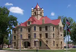 The McCulloch County Courthouse in Brady | |
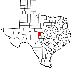 Location within the U.S. state of Texas | |
 Texas's location within the U.S. | |
| Coordinates: 31°12′N 99°21′W | |
| Country | |
| State | |
| Founded | 1876 |
| Named for | Benjamin McCulloch |
| Seat | Brady |
| Largest city | Brady |
| Area | |
| • Total | 1,073 sq mi (2,780 km2) |
| • Land | 1,066 sq mi (2,760 km2) |
| • Water | 7.8 sq mi (20 km2) 0.7%% |
| Population (2010) | |
| • Total | 8,283 |
| • Density | 7.8/sq mi (3.0/km2) |
| Time zone | UTC−6 (Central) |
| • Summer (DST) | UTC−5 (CDT) |
| Congressional district | 11th |
| Website | www |
The geographical center of Texas lies within McCulloch County, near Brady.[4]
History
From 5000 BC to 1500 AD, the early Native American inhabitants included Tonkawa, Lipan Apache, Comanche, and Tawakoni.[5] The 1788 José Mares expedition passed through the area while travelling from San Antonio to Santa Fe.[6]
On November 21, 1831, in the Brady vicinity, James Bowie, Rezin P. Bowie, David Buchanan, Cephas D. Hamm, Matthew Doyle, Jesse Wallace, Thomas McCaslin, Robert Armstrong, and James Coryell with two servants, Charles and Gonzales, held at bay for a day and a night 164 Caddo and Lipans. After 80 warriors had been killed, the Indians withdrew.[7] Camp San Saba was established in 1852 to protect settlers from Indians.[8] The Sixth Texas Legislature in 1856 formed McCulloch County from Bexar County, and named it for Benjamin McCulloch.[5] The Voca waterwheel mill was built in 1876.[9]
The Brady Sentinel was established by D.F. Hayes in 1880 as the county's first newspaper. Later, it was absorbed by the Heart o’ Texas News run by R.B. Boyle.[5] During 1886–1912, the Swedish colonies of East Sweden,[10] West Sweden[11] and Melvin[12] were established. From 1897 to 1910, the Brady Enterprise or McCulloch County Enterprise was published.[5] In 1899, the McCulloch County sandstone courthouse built in the Romanesque Revival style by architects Martin and Moodie.[13] In the last year of the 19th century, the Milburn Messenger was edited by T.F. Harwell. Cotton became a major county crop.[5] Three years later, the Fort Worth and Rio Grande Railway came to McCulloch County.[5] W.D. Currie published the Mercury Mascot from 1904 to 1907.[5] In 1906–1910, the McCulloch County Star was published.[5] In 1909, the Brady Standard, edited by F.W. Schwenker, began publication, and absorbed the McCulloch County Star and the Brady Enterprise in 1910.[5] The Rochelle Record was started by W.D. Cowan in 1909.[5] The Melvin Rustler began publication in 1915.[5] in 1917, J. Marvin Hunter founded the Melvin Enterprise.[5]
During the 1920s, McCulloch County billed itself as "the Turkey Center of the Universe", and held an annual Turkey Trot.[5]
Tenant farming in the county peaked at 60% in the 1930s.[5]
The Colorado River flooded in 1932, cresting at 62.2 feet (19.0 m).[5] In 1938, Brady Creek flooded, cresting at 29.1 feet (8.9 m). The San Saba River flooded, cresting at 39.8 feet (12.1 m).[14]
Curtis Field, named for Brady Mayor Harry L. Curtis, opened as a flying school in 1941, with 80 students.[15] A county prisoner-of-war camp was set up in 1943; it housed members of Rommel's Afrika Corps, the S.S., and the Gestapo.[5] Crockett State School took over the former POW camp in 1946, and used it as a training school for delinquent black girls.[16]
From 1954 to 1960, 48 restraining structures were installed in the county to control flooding.[5] Brady Creek Reservoir was constructed to partially control flooding on Brady Creek in 1963.[17] A tourist information marker placed in the county, declaring the geographical center of Texas.[18]
Geography
According to the U.S. Census Bureau, the county has a total area of 1,073 square miles (2,780 km2), of which 1,066 square miles (2,760 km2) are land and 7.8 square miles (20 km2) (0.7%) are covered by water.[19]
Major highways
 U.S. Highway 87
 U.S. Highway 190
 U.S. Highway 283
 U.S. Highway 377
 State Highway 71
Adjacent counties
- Coleman County (north)
- Brown County (northeast)
- San Saba County (east)
- Mason County (south)
- Menard County (southwest)
- Concho County (west)
Demographics
| Historical population | |||
|---|---|---|---|
| Census | Pop. | %± | |
| 1870 | 173 | — | |
| 1880 | 1,533 | 786.1% | |
| 1890 | 3,217 | 109.8% | |
| 1900 | 3,960 | 23.1% | |
| 1910 | 13,405 | 238.5% | |
| 1920 | 11,020 | −17.8% | |
| 1930 | 13,883 | 26.0% | |
| 1940 | 13,208 | −4.9% | |
| 1950 | 11,701 | −11.4% | |
| 1960 | 8,815 | −24.7% | |
| 1970 | 8,571 | −2.8% | |
| 1980 | 8,735 | 1.9% | |
| 1990 | 8,778 | 0.5% | |
| 2000 | 8,205 | −6.5% | |
| 2010 | 8,283 | 1.0% | |
| 2019 (est.) | 7,984 | [20] | −3.6% |
| U.S. Decennial Census[21] 1850–2010[22] 2010–2014[1] | |||
At the 2000 census,[23] 8,205 people, 3,277 households and 2,267 families resided in the county. The population density was 8 per square mile (3/km2). The 4,184 housing units averaged 4 per square mile (2/km2). The racial makeup of the county was 84.64% White, 1.57% Black or African American, 0.26% Native American, 0.17% Asian, 0.01% Pacific Islander, 11.71% from other races, and 1.63% from two or more races. About 27% of the population were Hispanic or Latinos of any race.
Of the 3,277 households, 30.70% had children under the age of 18 living with them, 55.30% were married couples living together, 10.20% had a female householder with no husband present, and 30.80% were not families. About 28.20% of all households were made up of individuals, and 15.80% had someone living alone who was 65 years of age or older. The average household size was 2.47 and the average family size was 3.01. About 26.60% of the population were under the age of 18, 6.60% from 18 to 24, 22.90% from 25 to 44, 24.30% from 45 to 64, and 19.50% who were 65 years of age or older. The median age was 40 years. For every 100 females, there were 90.10 males. For every 100 females age 18 and over, there were 86.00 males.
The median household income was $25,705 and family income was $30,783. Males had a median income of $25,844 versus $18,337 for females. The per capita income for the county was $14,579. About 17.30% of families and 22.50% of the population were below the poverty line, including 28.40% of those under age 18 and 21.50% of those age 65 or over.
Government and infrastructure
In 1947, the State of Texas opened the Brady State School for Negro Girls in McCulloch County, near Brady on a former prisoner of war camp leased from the federal government of the United States. In 1950, the state replaced the Brady facility with the Crockett State School.[16]
Politics
| Year | Republican | Democratic | Third parties |
|---|---|---|---|
| 2016 | 82.2% 2,552 | 15.5% 482 | 2.2% 69 |
| 2012 | 80.8% 2,419 | 17.9% 537 | 1.2% 37 |
| 2008 | 75.2% 2,263 | 24.2% 728 | 0.6% 19 |
| 2004 | 76.6% 2,465 | 23.1% 745 | 0.3% 10 |
| 2000 | 71.4% 2,084 | 27.2% 794 | 1.4% 42 |
| 1996 | 48.7% 1,465 | 40.9% 1,231 | 10.4% 312 |
| 1992 | 31.7% 1,108 | 39.9% 1,393 | 28.4% 990 |
| 1988 | 49.1% 1,618 | 50.6% 1,665 | 0.3% 10 |
| 1984 | 58.8% 2,060 | 40.9% 1,433 | 0.3% 9 |
| 1980 | 46.7% 1,572 | 52.0% 1,750 | 1.3% 44 |
| 1976 | 40.5% 1,300 | 58.9% 1,888 | 0.6% 19 |
| 1972 | 70.1% 1,769 | 29.8% 753 | 0.1% 3 |
| 1968 | 35.6% 947 | 50.9% 1,353 | 13.5% 359 |
| 1964 | 23.7% 655 | 76.1% 2,100 | 0.2% 6 |
| 1960 | 42.4% 1,165 | 57.5% 1,579 | 0.2% 4 |
| 1956 | 52.6% 1,292 | 47.2% 1,158 | 0.2% 5 |
| 1952 | 52.3% 1,788 | 47.5% 1,623 | 0.3% 9 |
| 1948 | 14.9% 393 | 81.9% 2,166 | 3.2% 85 |
| 1944 | 16.5% 463 | 74.5% 2,088 | 9.0% 253 |
| 1940 | 15.7% 443 | 84.3% 2,373 | |
| 1936 | 15.3% 323 | 83.9% 1,772 | 0.8% 16 |
| 1932 | 11.6% 265 | 88.1% 2,006 | 0.3% 6 |
| 1928 | 63.6% 1,294 | 36.4% 741 | |
| 1924 | 26.8% 495 | 72.0% 1,327 | 1.2% 22 |
| 1920 | 19.2% 210 | 71.2% 780 | 9.7% 106 |
| 1916 | 6.0% 61 | 82.6% 847 | 11.4% 117 |
| 1912 | 4.9% 41 | 70.3% 595 | 24.8% 210 |
Education
The following school districts serve McCulloch County:
- Brady ISD (small portion in Concho County)
- Lohn ISD
- Mason ISD (mostly in Mason County; small portions in Kimble, Menard, and San Saba Counties)
- Rochelle ISD
See also
References
- "State & County QuickFacts". United States Census Bureau. Archived from the original on October 18, 2011. Retrieved December 21, 2013.
- "Find a County". National Association of Counties. Archived from the original on May 31, 2011. Retrieved 2011-06-07.
- "Texas: Individual County Chronologies". Texas Atlas of Historical County Boundaries. The Newberry Library. 2008. Retrieved May 25, 2015.
- "Environment". Texas Almanac. Texas State Historical Association. Retrieved May 3, 2014.
- Smyrl, Vivian Elizabeth. "McCulloch County". Handbook of Texas Online. Texas State Historical Association. Retrieved 1 December 2010.
- Bolton, Herbert Eugene (1915). Texas in the middle eighteenth century: Studies in Spanish colonial history and administration. University of Michigan Library. p. 130.
- "Site of Indian Battle - Brady vicinity, McCulloch County, Texas". Texas Historical Markers. William Nienke, Sam Morrow. Archived from the original on 18 July 2011. Retrieved 1 December 2010.
- "Fort McKavett". Texas Escapes. Texas Escapes - Blueprints For Travel, LLC. Retrieved 1 December 2010.
- "Voca Waterwheel Mill". Texas Historical Markers. William Nienke, Sam Morrow. Archived from the original on 18 July 2011. Retrieved 1 December 2010.
- "East Sweden". Texas Historical Markers. Texas Escapes - Blueprints For Travel, LLC. Retrieved 1 December 2010.
- "West Sweden". Texas Historical Markers. Texas Escapes - Blueprints For Travel, LLC. Retrieved 1 December 2010.
- "Melvin". Texas Historical Markers. Texas Escapes - Blueprints For Travel, LLC. Retrieved 1 December 2010.
- "McCulloch County Courthouse". Texas Historical Markers. Texas Escapes - Blueprints For Travel, LLC. Retrieved 1 December 2010.
- Burnett, Jonathan (2008). Flash Floods in Texas. TAMU Press. pp. 111–128. ISBN 978-1-58544-590-5.
- "About Brady Curtis Airfield". Sandhills Publishing Company. Retrieved 1 December 2010.
- Smyrl, Vivian Elizabeth. "Crockett State School". Handbook of Texas Online. Texas State Historical Association. Retrieved 1 December 2010.
- Breeding, Seth D. "Brady Reservoir". Handbook of Texas Online. Texas State Historical Association. Retrieved 1 December 2010.
- "Geographic Center of Texas - Brady vicinity, McCulloch County, Texas". Texas State Historical Markers. William Nienke, Sam Morrow. Archived from the original on 18 July 2011. Retrieved 1 December 2010.
- "2010 Census Gazetteer Files". United States Census Bureau. August 22, 2012. Retrieved May 4, 2015.
- "Population and Housing Unit Estimates". United States Census Bureau. May 24, 2020. Retrieved May 27, 2020.
- "U.S. Decennial Census". United States Census Bureau. Retrieved May 4, 2015.
- "Texas Almanac: Population History of Counties from 1850–2010" (PDF). Texas Almanac. Retrieved May 4, 2015.
- "U.S. Census website". United States Census Bureau. Retrieved 2011-05-14.
- Leip, David. "Dave Leip's Atlas of U.S. Presidential Elections". uselectionatlas.org. Retrieved 11 April 2018.
External links
- McCulloch County from the Handbook of Texas Online
Places adjacent to McCulloch County, Texas | ||||||||||
|---|---|---|---|---|---|---|---|---|---|---|
| ||||||||||
Municipalities and communities of McCulloch County, Texas, United States | ||
|---|---|---|
| City | McCulloch County map | |
| Town | ||
| Unincorporated communities | ||
| ||

| Authority control |
|---|