Coke County, Texas
Coke County is a county located on the Edwards Plateau in the U.S. state of Texas. As of the 2010 census, its population was 3,320.[1] Its county seat is Robert Lee.[2] The county was founded in 1889 and is named for Richard Coke, the 15th governor of Texas. Coke County was one of 46 prohibition, or entirely dry, counties in the state of Texas, but passed a law allowing the sale of beer and wine in 2005.
Coke County | |
|---|---|
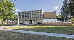 The Coke County Courthouse in Robert Lee | |
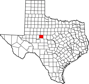 Location within the U.S. state of Texas | |
 Texas's location within the U.S. | |
| Coordinates: 31°53′N 100°32′W | |
| Country | |
| State | |
| Founded | 1889 |
| Named for | Richard Coke |
| Seat | Robert Lee |
| Largest city | Robert Lee |
| Area | |
| • Total | 928 sq mi (2,400 km2) |
| • Land | 911 sq mi (2,360 km2) |
| • Water | 17 sq mi (40 km2) 1.8%% |
| Population (2010) | |
| • Total | 3,320 |
| • Density | 3.6/sq mi (1.4/km2) |
| Time zone | UTC−6 (Central) |
| • Summer (DST) | UTC−5 (CDT) |
| Congressional district | 11th |
| Website | www |
History
Native Americans
From about 1700 to the 1870s, Comanche, Tonkawa, Lipan Apache, Kickapoo, and Kiowa roamed the county. These tribes settled in rock shelters in the river and creek valleys, leaving behind artifacts and caches of seeds, implements, burial sites, petroglyphs, river shells, turkey and deer bones, flint knives, scrapers, and points.[3][4]
Early years
In 1851, United States Army post Fort Chadbourne [5] was established to protect the frontier, and the fort was manned until the Civil War. The Butterfield Overland Mail [6] ran through the area from 1858 to 1861.
Between 1860 and the early 1880s, the only settlers in what became Coke County were ranchers attracted to open grazing land. J. J. Austin established his ranch headquarters near Sanco [7] in 1875. Pate Francher settled in the area in 1877.
In 1882, the Texas and Pacific Railway began providing service to San Angelo, and settlers started coming into the region in somewhat larger numbers.
Severe drought in the 1880s led to fence cutting and its attendant issues. State authorities eventually settled the disputes.
A few years later, the county was named after Confederate soldier, Texas leader, governor, and U.S senator Richard Coke.[8]
County history
The Texas Legislature established Coke County in 1889, out of Tom Green County. The county was organized that same year, with Hayrick [9] as county seat. The county's first newspaper, the Hayrick Democrat, began publication in 1889, but was renamed the Rustler.
In 1891, after an election, the new town of Robert Lee [10] became the county seat. Robert E. Lee had once served at Fort Chadbourne. That same year, the county's newspaper moved to the new county seat and was renamed the Robert Lee Observer.
Dr. D.W. Key [11][12] started the town of Bronte, named after English writer Charlotte Brontë.[13][14] The town was originally named Oso and then Bronco. A post office was granted in 1890 after residents changed the name to Bronte.
Silver, named after Silver Peak Summit,[15][16][17] was settled between 1870 and 1880 as a ranching hub. Early settlers were S.M. Conner, R.B. Allen, W.G. Jameson, and W.R. Walker. Dr. Joseph Eaton Reed was for 50 years the only physician. Oil discovery and related industries created a boom in Silver in the mid-20th century. After the oil camps closed down in 1966, Silver's population slipped drastically.
Tennyson, named in honor of the British poet Alfred, Lord Tennyson was established in 1892. It received a post office two years later.
The Kansas City, Mexico and Orient Railway built tracks north from San Angelo in 1907, which benefited Tennyson, Bronte, and Fort Chadbourne.
Cotton acreage peaked in 1910, but plunged sharply during the 1920s, because of a boll weevil infestation. Expanding during the same period was the production of corn, wheat, sorghum, and fruit trees. The county population declined during the Great Depression.
Oil was discovered in the county in 1942, and by 1991, 209,281,131 barrels (33,273,040.9 m3) had been taken from Coke County lands. Tax money derived from oil profits helped the county to improve infrastructure and public facilities and services for its citizens. Oil production accounts for the major share of income for the county.[18]
In 1995 Louis Jones murdered United States Army soldier Tracie Joy McBride in Coke County after having kidnapped her from Goodfellow Air Force Base in San Angelo, Texas.[19]
Geography
According to the United States Census Bureau, the county has a total area of 928 square miles (2,400 km2), of which 911 square miles (2,360 km2) are land and 17 square miles (44 km2) (1.8%) are covered by water.[20]
Major highways
 U.S. Highway 277
 State Highway 158
 State Highway 208
Adjacent counties
- Nolan County (north)
- Runnels County (east)
- Tom Green County (south)
- Sterling County (west)
- Mitchell County (northwest)
Demographics
| Historical population | |||
|---|---|---|---|
| Census | Pop. | %± | |
| 1890 | 2,059 | — | |
| 1900 | 3,430 | 66.6% | |
| 1910 | 6,412 | 86.9% | |
| 1920 | 4,557 | −28.9% | |
| 1930 | 5,253 | 15.3% | |
| 1940 | 4,590 | −12.6% | |
| 1950 | 4,045 | −11.9% | |
| 1960 | 3,589 | −11.3% | |
| 1970 | 3,087 | −14.0% | |
| 1980 | 3,196 | 3.5% | |
| 1990 | 3,424 | 7.1% | |
| 2000 | 3,864 | 12.9% | |
| 2010 | 3,320 | −14.1% | |
| 2019 (est.) | 3,387 | [21] | 2.0% |
| U.S. Decennial Census[22] 1850–2010[23] 2010–2014[1] | |||
At the 2000 census,[24] 3,864 people, 1,544 households and 1,068 families resided in the county. The population density was four per square mile (2/km2). The 2,843 housing units averaged three per square mile. The racial makeup of the county was 88.85% White, 1.94% Black or African American, 0.78% Native American, 0.08% Asian, 0.03% Pacific Islander, 6.94% from other races] and 1.40% from two or more races. About 16.90% of the population was Hispanic or Latino of any race.
Of the 1,544 households, 27.10% had children under the age of 18 living with them, 58.40% were married couples living together, 8.10% had a female householder with no husband present, and 30.80% were not families; 29.00% of all households was made up of individuals, and 18.30% had someone living alone who was 65 years of age or older. The average household size was 2.31, and the average family size was 2.84.
Age distribution was 24.40% under the age of 18, 7.50% from 18 to 24, 20.50% from 25 to 44, 23.60% from 45 to 64, and 24.10% who were 65 years of age or older. The median age was 43 years. For every 100 females, there were 100.00 males. For every 100 females age 18 and over, there were 94.20 males.
The median household income was $29,085, and the median family was $36,724. Males had a median income of $30,778 versus $19,596 for females. The per capita income for the county was $16,734. About 9.70% of families and 13.00% of the population were below the poverty line, including 15.00% of those under age 18 and 12.80% of those age 65 or over.
Communities
Cities
- Blackwell (mostly in Nolan County)
- Robert Lee (county seat)
Town
Ghost town
- Edith
- Juniper
Politics
| Year | Republican | Democratic | Third parties |
|---|---|---|---|
| 2020 | 89.2% 1,586 | 10.0% 178 | 0.8% 15 |
| 2016 | 88.9% 1,265 | 9.8% 140 | 1.3% 18 |
| 2012 | 86.5% 1,218 | 12.7% 179 | 0.8% 11 |
| 2008 | 79.8% 1,252 | 19.1% 299 | 1.2% 18 |
| 2004 | 83.1% 1,338 | 16.5% 266 | 0.4% 6 |
| 2000 | 75.1% 1,137 | 23.4% 355 | 1.5% 23 |
| 1996 | 51.1% 790 | 38.5% 595 | 10.4% 161 |
| 1992 | 39.7% 640 | 35.9% 580 | 24.4% 394 |
| 1988 | 56.0% 863 | 43.7% 674 | 0.3% 5 |
| 1984 | 66.3% 1,060 | 33.3% 532 | 0.5% 8 |
| 1980 | 45.4% 708 | 53.8% 838 | 0.8% 12 |
| 1976 | 37.6% 517 | 61.3% 844 | 1.2% 16 |
| 1972 | 67.1% 761 | 31.6% 358 | 1.3% 15 |
| 1968 | 33.4% 387 | 48.6% 563 | 18.0% 209 |
| 1964 | 28.8% 366 | 70.9% 900 | 0.2% 3 |
| 1960 | 41.4% 575 | 57.6% 799 | 1.0% 14 |
| 1956 | 44.1% 549 | 55.4% 690 | 0.5% 6 |
| 1952 | 43.7% 576 | 55.9% 736 | 0.4% 5 |
| 1948 | 6.5% 65 | 90.2% 909 | 3.4% 34 |
| 1944 | 6.8% 65 | 85.9% 824 | 7.3% 70 |
| 1940 | 8.8% 94 | 90.7% 967 | 0.5% 5 |
| 1936 | 7.0% 68 | 91.9% 888 | 1.0% 10 |
| 1932 | 5.4% 57 | 93.9% 983 | 0.7% 7 |
| 1928 | 68.6% 450 | 31.4% 206 | |
| 1924 | 10.4% 80 | 87.9% 673 | 1.7% 13 |
| 1920 | 10.4% 59 | 78.6% 444 | 11.0% 62 |
| 1916 | 5.2% 29 | 86.7% 484 | 8.1% 45 |
| 1912 | 2.1% 7 | 90.4% 301 | 7.5% 25 |
See also
References
- "State & County QuickFacts". United States Census Bureau. Archived from the original on September 5, 2015. Retrieved December 9, 2013.
- "Find a County". National Association of Counties. Archived from the original on 2011-05-31. Retrieved 2011-06-07.
- Handbook of Texas, Coke County
- Texas Historical Markers, Indian Rock Shelters Archived 2012-03-01 at the Wayback Machine
- Fort Chadbourne
- Texas Historical Markers, Route of Southern Overland Mail Archived 2012-03-01 at the Wayback Machine
- Texas Escapes, Sanco
- Gannett, Henry (1905). The Origin of Certain Place Names in the United States. Govt. Print. Off. pp. 86.
- Texas Escapes, Hayrick
- Texas Escapes, Robert Lee
- TexGen Web Dr. Wesley Fletcher Key
- TexGenWeb Keys of West Texas
- Texas Escapes, Bronte
- Texas Historical Markers, Bronte Archived 2012-03-01 at the Wayback Machine
- Mountain Zone.com, Silver Peak Summit
- "Texas Historical Markers, Silver". Archived from the original on 2012-03-01. Retrieved 2010-04-13.
- Texas Escapes, Silver
- Texas Historical Markers, First Producing Well in Coke County Archived 2012-03-14 at the Wayback Machine
- "Louis Jones." Texas Department of Criminal Justice. Retrieved on July 18, 2016.
- "2010 Census Gazetteer Files". United States Census Bureau. August 22, 2012. Retrieved April 21, 2015.
- "Population and Housing Unit Estimates". United States Census Bureau. May 24, 2020. Retrieved May 27, 2020.
- "U.S. Decennial Census". United States Census Bureau. Retrieved April 21, 2015.
- "Texas Almanac: Population History of Counties from 1850–2010" (PDF). Texas Almanac. Retrieved April 21, 2015.
- "U.S. Census website". United States Census Bureau. Retrieved 2011-05-14.
- Leip, David. "Dave Leip's Atlas of U.S. Presidential Elections". uselectionatlas.org. Retrieved 2018-07-20.
External links
- Coke County government's website
- Coke County in Handbook of Texas Online
- Coke County Profile from the Texas Association of Counties
Places adjacent to Coke County, Texas | ||||||||||
|---|---|---|---|---|---|---|---|---|---|---|
| ||||||||||
Municipalities and communities of Coke County, Texas, United States | ||
|---|---|---|
| Cities | Coke County map | |
| Town | ||
| Unincorporated communities | ||
| Ghost town | ||
| Footnotes | ‡This populated place also has portions in an adjacent county or counties | |
| ||

| Authority control |
|---|