National Register of Historic Places listings in Pottawattamie County, Iowa
This is a list of the National Register of Historic Places listings in Pottawattamie County, Iowa.
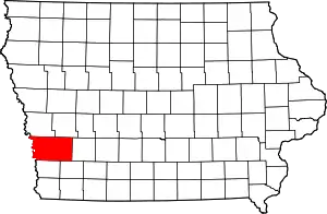
Location of Pottawattamie County in Iowa
This is intended to be a complete list of the properties and districts on the National Register of Historic Places in Pottawattamie County, Iowa, United States. Latitude and longitude coordinates are provided for many National Register properties and districts; these locations may be seen together in a map.[1]
There are 39 properties and districts listed on the National Register in the county, including one National Historic Landmark. Three other sites were once listed on the Register but have been removed.
- This National Park Service list is complete through NPS recent listings posted February 5, 2021.[2]
| [3] | Name on the Register[4] | Image | Date listed[5] | Location | City or town | Description |
|---|---|---|---|---|---|---|
| 1 | 100 Block of West Broadway Historic District | 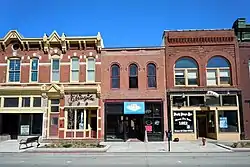 100 Block of West Broadway Historic District |
May 9, 2002 (#02000455) |
W. Broadway, 1st St., and 4th St. 41°15′46″N 95°50′42″W |
Council Bluffs | |
| 2 | Bennett Building | 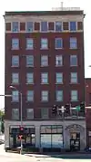 Bennett Building |
August 8, 2001 (#01000861) |
405 West Broadway 41°15′38″N 95°50′57″W |
Council Bluffs | |
| 3 | August Beresheim House | 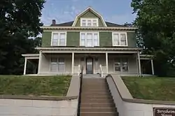 August Beresheim House |
August 13, 1976 (#76000802) |
621 3rd St. 41°15′16″N 95°50′52″W |
Council Bluffs | |
| 4 | Jean and Inez Bregant House | 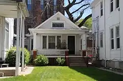 Jean and Inez Bregant House |
October 16, 2013 (#13000832) |
517 S. 4th Street 41°15′23″N 95°51′01″W |
Council Bluffs | |
| 5 | Carstens Farmstead | July 10, 1979 (#79000932) |
South of Shelby on Iowa Highway 168 41°28′57″N 95°27′22″W |
Shelby | ||
| 6 | Thomas E. Cavin House | 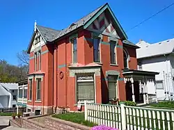 Thomas E. Cavin House |
September 27, 1984 (#84001306) |
150 Park Ave. 41°15′36″N 95°50′39″W |
Council Bluffs | |
| 7 | Chevra B'nai Yisroel Synagogue | Chevra B'nai Yisroel Synagogue |
March 7, 2007 (#07000113) |
618 Mynster St. 41°15′52″N 95°51′09″W |
Council Bluffs | |
| 8 | Chicago, Rock Island & Pacific Railroad Passenger Depot |  Chicago, Rock Island & Pacific Railroad Passenger Depot |
July 21, 1995 (#95000856) |
1512 S. Main St. 41°14′49″N 95°51′08″W |
Council Bluffs | |
| 9 | Council Bluffs Free Public Library | 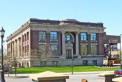 Council Bluffs Free Public Library |
January 27, 1999 (#99000048) |
200 Pearl St. 41°15′29″N 95°51′04″W |
Council Bluffs | |
| 10 | Grenville M. Dodge House | 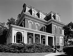 Grenville M. Dodge House |
October 15, 1966 (#66000338) |
605 S. 3rd St. 41°15′17″N 95°50′50″W |
Council Bluffs | |
| 11 | Ruth Anne Dodge Memorial | 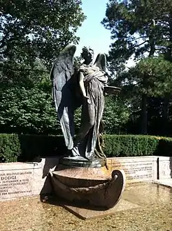 Ruth Anne Dodge Memorial |
February 8, 1980 (#80001457) |
Fairview Cemetery 41°16′02″N 95°50′51″W |
Council Bluffs | |
| 12 | Eckle Round Barn | June 30, 1986 (#86001470) |
Off Iowa Highway 168 41°30′20″N 95°29′37″W |
Shelby | part of the Iowa Round Barns: The Sixty Year Experiment Thematic Resource (TR) | |
| 13 | Shepard and Emma Farnsworth House | June 29, 2018 (#100002621) |
301 S 8th St. 41°15′31″N 95°51′22″W |
Council Bluffs | ||
| 14 | German Bank Building of Walnut, Iowa | 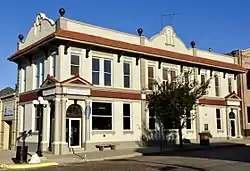 German Bank Building of Walnut, Iowa |
May 1, 1991 (#91000536) |
Junction of Highland and Central Sts. 41°28′39″N 95°13′20″W |
Walnut | |
| 15 | Graceland Cemetery Chapel | 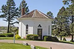 Graceland Cemetery Chapel |
April 28, 1986 (#86000873) |
Graceland Cemetery, U.S. Route 59 41°29′32″N 95°20′15″W |
Avoca | |
| 16 | Haymarket Commercial Historic District | 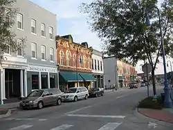 Haymarket Commercial Historic District |
April 11, 1985 (#85000774) |
S. Main St. 41°15′22″N 95°51′25″W |
Council Bluffs | |
| 17 | Hotel Chieftain | 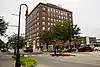 Hotel Chieftain |
June 6, 2014 (#14000286) |
38 Pearl St. 41°15′36″N 95°51′03″W |
Council Bluffs | |
| 18 | Martin Hughes House | 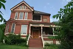 Martin Hughes House |
September 27, 1984 (#84001310) |
903 3rd St. 41°15′11″N 95°50′53″W |
Council Bluffs | |
| 19 | Hughes-Irons Motor Company | 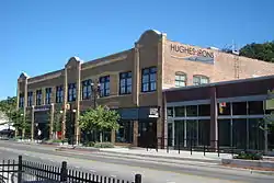 Hughes-Irons Motor Company |
June 23, 2011 (#11000392) |
149-161 W. Broadway 41°15′45″N 95°50′42″W |
Council Bluffs | |
| 20 | Thomas Jefferis House | 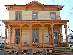 Thomas Jefferis House |
December 25, 1979 (#79000928) |
523 6th Ave. 41°15′21″N 95°51′07″W |
Council Bluffs | |
| 21 | Lincoln-Fairview Historic District | 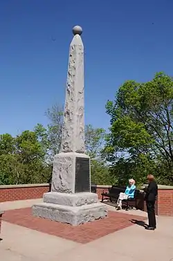 Lincoln-Fairview Historic District |
April 10, 2007 (#07000281) |
Roughly bounded by W. Kanesville Boulevard, Oakland Ave., Fairview Cemetery, and N. 1st St. 41°15′58″N 95°50′51″W |
Council Bluffs | |
| 22 | McCormick Harvesting Machine Company Building | 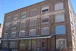 McCormick Harvesting Machine Company Building |
September 10, 2012 (#12000780) |
1001 S. 6th St. 41°15′09″N 95°51′11″W |
Council Bluffs | |
| 23 | Charles Henry and Charlotte Norton House | 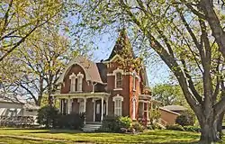 Charles Henry and Charlotte Norton House |
December 30, 2004 (#04001401) |
401 N. Chestnut St. 41°28′47″N 95°20′11″W |
Avoca | |
| 24 | Park/Glen Avenues Historic District | 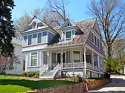 Park/Glen Avenues Historic District |
April 7, 2010 (#10000160) |
101-508 Glen Ave., 102-471 Park Ave., 209 & 301 W. Pierce, & 524 & 600 Huntington 41°15′32″N 95°50′38″W |
Council Bluffs | |
| 25 | Pioneer Implement Company | 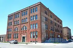 Pioneer Implement Company |
April 30, 2008 (#08000357) |
1000 S. Main St. 41°15′09″N 95°51′06″W |
Council Bluffs | |
| 26 | Pottawattamie County Jail |  Pottawattamie County Jail |
March 16, 1972 (#72000481) |
226 Pearl St. 41°16′35″N 95°50′39″W |
Council Bluffs | |
| 27 | Pottawattamie County Sub Courthouse | 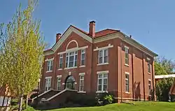 Pottawattamie County Sub Courthouse |
July 2, 1981 (#81000265) |
Elm St. 41°28′41″N 95°20′19″W |
Avoca | part of the County Courthouses in Iowa TR |
| 28 | Reverend Little's Young Ladies Seminary | 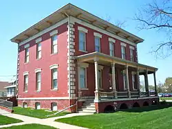 Reverend Little's Young Ladies Seminary |
February 4, 1982 (#82002637) |
541 6th Ave. 41°15′22″N 95°51′08″W |
Council Bluffs | |
| 29 | St. Peter's Church and Rectory | 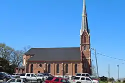 St. Peter's Church and Rectory |
July 24, 1992 (#92000923) |
1 Bluff St. 41°15′37″N 95°50′50″W |
Council Bluffs | |
| 30 | Sandwich–Marseilles Manufacturing Building | 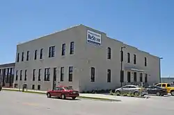 Sandwich–Marseilles Manufacturing Building |
May 27, 2014 (#14000253) |
1216–1230 S. Main St. 41°14′59″N 95°51′07″W |
Council Bluffs | |
| 31 | John J. and Agnes Shea House | 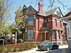 John J. and Agnes Shea House |
November 22, 1995 (#95001315) |
309 S. 8th St. 41°15′29″N 95°51′19″W |
Council Bluffs | |
| 32 | South 8th Street Historic District | June 25, 2020 (#100005299) |
Bounded by South 7th St., South 8th St., 1st Ave., 7th Ave., with segment along 2nd Ave. extending to South 10th St. 41°15′30″N 95°51′20″W |
Council Bluffs | ||
| 33 | State Savings Bank | 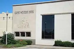 State Savings Bank |
June 4, 1984 (#84001312) |
509 W. Broadway 41°15′39″N 95°51′02″W |
Council Bluffs | |
| 34 | Lysander Tulleys House | 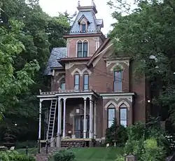 Lysander Tulleys House |
October 18, 1979 (#79000929) |
151 Park Ave. 41°15′37″N 95°50′38″W |
Council Bluffs | |
| 35 | Francis A. and Rose M. Turner House | January 31, 1997 (#96001583) |
1004 Cherry St. 41°30′06″N 95°20′06″W |
Avoca | ||
| 36 | O.P. Wickham House | 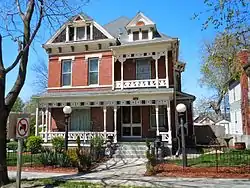 O.P. Wickham House |
June 18, 1979 (#79000930) |
616 S. 7th St. 41°15′19″N 95°51′17″W |
Council Bluffs | |
| 37 | Wickham-De Vol House | 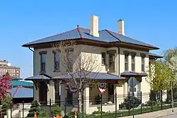 Wickham-De Vol House |
May 4, 1995 (#95000557) |
332 Willow Ave. 41°15′30″N 95°50′54″W |
Council Bluffs | |
| 38 | Willow-Bluff-3rd Street Historic District | 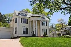 Willow-Bluff-3rd Street Historic District |
September 15, 2005 (#05001019) |
Roughly bounded by Worth, High School Ave., Clark Ave., and the western side of Bluff St. 41°15′24″N 95°50′51″W |
Council Bluffs | |
| 39 | Y.M.C.A. Building | 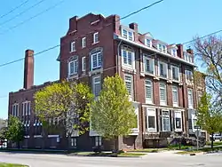 Y.M.C.A. Building |
June 27, 1979 (#79000931) |
628 1st Ave. 41°15′37″N 95°51′13″W |
Council Bluffs |
Former listings
| [3] | Name on the Register | Image | Date listed | Date removed | Location | City or town | Summary |
|---|---|---|---|---|---|---|---|
| 1 | Hancock Savings Bank | January 19, 1983 (#83000401) | December 19, 2014 | 311 Main St. 41°23′27″N 95°21′43″W |
Hancock | ||
| 2 | Ogden House | September 13, 1976 (#76000803) | March 27, 2007 | 169 West Broadway 41°15′44″N 95°50′44″W |
Council Bluffs | ||
| 3 | South Omaha Bridge | South Omaha Bridge |
June 29, 1992 (#92000742) | July 14, 2011 | U.S. Route 275/Nebraska Highway 92 over the Missouri River 41°12′47″N 95°55′57″W |
Council Bluffs | Spanned Missouri River to Council Bluffs, Iowa; part of the Highway Bridges in Nebraska Multiple Property Submission (MPS); demolished in February and March 2010[6] |
See also
| Wikimedia Commons has media related to National Register of Historic Places in Pottawattamie County, Iowa. |
References
- The latitude and longitude information provided in this table was derived originally from the National Register Information System, which has been found to be fairly accurate for about 99% of listings. Some locations in this table may have been corrected to current GPS standards.
- "National Register of Historic Places: Weekly List Actions". National Park Service, United States Department of the Interior. Retrieved on February 5, 2021.
- Numbers represent an alphabetical ordering by significant words. Various colorings, defined here, differentiate National Historic Landmarks and historic districts from other NRHP buildings, structures, sites or objects.
- "National Register Information System". National Register of Historic Places. National Park Service. April 24, 2008.
- The eight-digit number below each date is the number assigned to each location in the National Register Information System database, which can be viewed by clicking the number.
- Kaufman, Kirby (March 14, 2010). "Rest of Veterans bridge demolished". Omaha World-Herald. Archived from the original on September 11, 2012. Retrieved July 27, 2011.
| Topics | |
|---|---|
| Lists by state |
|
| Lists by insular areas | |
| Lists by associated state | |
| Other areas | |
| Related | |
| |

Municipalities and communities of Pottawattamie County, Iowa, United States | ||
|---|---|---|
| Cities | Map of Iowa highlighting Pottawattamie County | |
| Townships | ||
| CDPs | ||
| Other community | ||
| Footnotes | ‡This populated place also has portions in an adjacent county or counties | |
| ||
This article is issued from Wikipedia. The text is licensed under Creative Commons - Attribution - Sharealike. Additional terms may apply for the media files.