National Register of Historic Places listings in Cerro Gordo County, Iowa
This is a list of the National Register of Historic Places listings in Cerro Gordo County, Iowa.
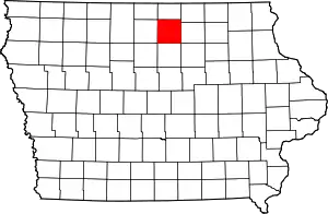
Location of Cerro Gordo County in Iowa
This is intended to be a complete list of the properties and districts on the National Register of Historic Places in Cerro Gordo County, Iowa, United States. Latitude and longitude coordinates are provided for many National Register properties and districts; these locations may be seen together in a map.[1]
There are 44 properties and districts listed on the National Register in the county, one of which is a National Historic Landmark.
- This National Park Service list is complete through NPS recent listings posted January 29, 2021.[2]
| [3] | Name on the Register[4] | Image | Date listed[5] | Location | City or town | Description |
|---|---|---|---|---|---|---|
| 1 | A.J. Andrus Duplex | 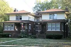 A.J. Andrus Duplex |
January 29, 1980 (#80001431) |
687-691 E. State St. 43°09′05″N 93°11′14″W |
Mason City | |
| 2 | Amaziah and Cornelia (Wait) Cannon House | 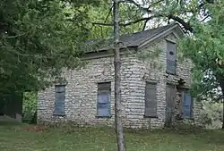 Amaziah and Cornelia (Wait) Cannon House |
August 25, 2004 (#04000899) |
1581 N. Eisenhower Ave. 43°10′02″N 93°15′37″W |
Mason City | |
| 3 | City National Bank Building |  City National Bank Building |
September 14, 1972 (#72000469) |
4 S. Federal Ave. 43°09′06″N 93°12′05″W |
Mason City | |
| 4 | East Park Band Shell | 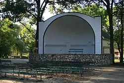 East Park Band Shell |
October 14, 2009 (#09000825) |
E. State St. between N. Carolina Ave. and N. Kentucky Ave. 43°09′14″N 93°11′01″W |
Mason City | |
| 5 | East Park Historic District | 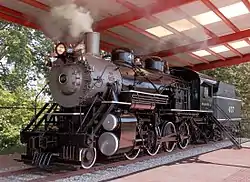 East Park Historic District |
October 15, 2014 (#14000855) |
Roughly bounded by the Winnebago R., N. Carolina, N. Kentucky & N. Virginia Aves., CPRR tracks, E. State St. 43°09′20″N 93°11′02″W |
Mason City | |
| 6 | William C. and Margaret Egloff House | 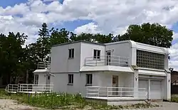 William C. and Margaret Egloff House |
May 1, 2017 (#100000934) |
310 E. State St. 43°09′07″N 93°11′45″W |
Mason City | |
| 7 | Elks-Rogers Hotel | Elks-Rogers Hotel |
June 21, 1982 (#82002611) |
223 Main Ave. 43°08′08″N 93°22′54″W |
Clear Lake | |
| 8 | Elmwood-St. Joseph Municipal Cemetery Historic District | June 7, 2018 (#100002541) |
1224 S Washington Ave. 43°08′23″N 93°12′18″W |
Mason City | ||
| 9 | John L. Etzel House | 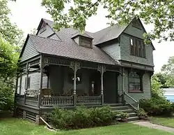 John L. Etzel House |
January 27, 1983 (#83000347) |
214 N. 3rd St. 43°08′17″N 93°23′02″W |
Clear Lake | |
| 10 | First Church of Christ Scientist | 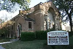 First Church of Christ Scientist |
October 30, 1997 (#97001285) |
23 3rd St., NW. 43°09′16″N 93°12′08″W |
Mason City | |
| 11 | First National Bank of Mason City | 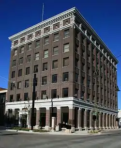 First National Bank of Mason City |
May 2, 1997 (#97000392) |
5-7 N. Federal Ave. 43°09′07″N 93°12′03″W |
Mason City | |
| 12 | Forest Park Historic District | 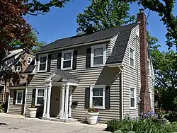 Forest Park Historic District |
January 20, 2015 (#14001167) |
Roughly bounded by Willow Cr., Crescent & Linden Drs., State St., S. Pierce & N. Taylor Aves., 1st St. SW. 43°09′14″N 93°13′02″W |
Mason City | |
| 13 | C.F. Franke House | 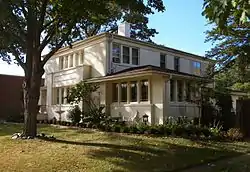 C.F. Franke House |
January 29, 1980 (#80001432) |
320 1st St., SE. 43°09′04″N 93°11′43″W |
Mason City | |
| 14 | E.R. Gibson House | 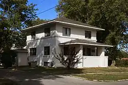 E.R. Gibson House |
January 29, 1980 (#80001433) |
114 4th St., NW. 43°09′20″N 93°12′12″W |
Mason City | |
| 15 | Hotel Lester-Lester Cafe | 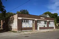 Hotel Lester-Lester Cafe |
December 20, 2002 (#02001543) |
408-410 2nd St., NW. 43°09′14″N 93°12′28″W |
Mason City | |
| 16 | Jewell Apartments | 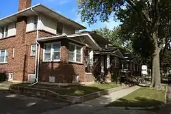 Jewell Apartments |
January 29, 1980 (#80001434) |
404-412 1st St., NW. 43°09′10″N 93°12′28″W |
Mason City | |
| 17 | Keerl-Decker House | 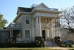 Keerl-Decker House |
December 20, 2002 (#02001537) |
119 2nd St., SE. 43°08′59″N 93°11′55″W |
Mason City | |
| 18 | The Kirk | 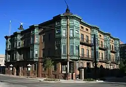 The Kirk |
April 12, 1982 (#82002613) |
206 N. Federal Ave. 43°09′14″N 93°12′05″W |
Mason City | |
| 19 | Lippert House | 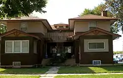 Lippert House |
January 29, 1980 (#80001435) |
122-124 N. Madison Ave. 43°09′12″N 93°12′28″W |
Mason City | |
| 20 | Mason City Downtown Historic District | 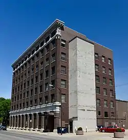 Mason City Downtown Historic District |
September 8, 2005 (#05000956) |
Roughly bounded by N. 46th St., Georgia Ave., Washington Ave., and S. 2nd St. 43°09′10″N 93°12′04″W |
Mason City | |
| 21 | Mason City Public Library | 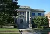 Mason City Public Library |
May 25, 1989 (#89000405) |
208 E. State St. 43°09′07″N 93°11′51″W |
Mason City | |
| 22 | Mason City YMCA | 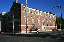 Mason City YMCA |
May 2, 2002 (#02000426) |
15 N. Pennsylvania 43°09′09″N 93°11′51″W |
Mason City | |
| 23 | MBA (Modern Brotherhood of America) Building | 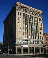 MBA (Modern Brotherhood of America) Building |
September 12, 2002 (#02001021) |
103 E. State St. 43°09′04″N 93°11′57″W |
Mason City | |
| 24 | F.M. Norris House | January 29, 1980 (#80001436) |
108 4th St., NE. 43°09′20″N 93°11′56″W |
Mason City | ||
| 25 | Park Inn Hotel | 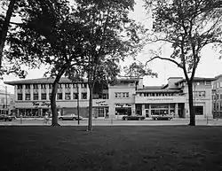 Park Inn Hotel |
September 14, 1972 (#72000470) |
15 W. State St. 43°09′06″N 93°12′06″W |
Mason City | |
| 26 | Parker's Opera House | 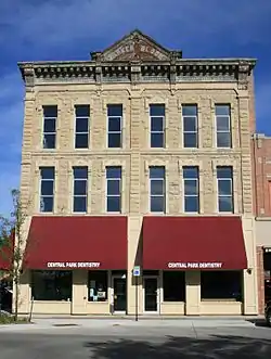 Parker's Opera House |
November 20, 1998 (#98001325) |
23 N. Federal Ave. 43°09′09″N 93°12′02″W |
Mason City | |
| 27 | Parker's Woods Park Historic District |  Parker's Woods Park Historic District |
October 15, 2014 (#14000856) |
N. Jackson Ave. between 1st & 4th Sts., NW. 43°09′15″N 93°12′45″W |
Mason City | |
| 28 | Rock Crest – Rock Glen Historic District |  Rock Crest – Rock Glen Historic District |
December 28, 1979 (#79000885) |
Off U.S. Route 18 43°09′02″N 93°11′32″W |
Mason City | |
| 29 | Rock Falls Bridge | June 25, 1998 (#98000742) |
Spring St. over the Shell Rock River 43°12′24″N 93°05′04″W |
Rock Falls | ||
| 30 | Rogers-Knutson House | 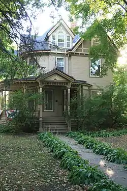 Rogers-Knutson House |
September 9, 1982 (#82002612) |
315 N. 3rd St. 43°08′19″N 93°23′07″W |
Clear Lake | |
| 31 | George Romey House | 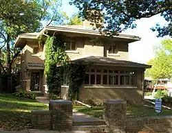 George Romey House |
January 29, 1980 (#80001437) |
428 1st St., SE. 43°09′04″N 93°11′36″W |
Mason City | |
| 32 | Duncan Rule House | 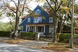 Duncan Rule House |
October 16, 1979 (#79000886) |
321 2nd St., SE. 43°08′59″N 93°11′43″W |
Mason City | |
| 33 | Chris Rye House | 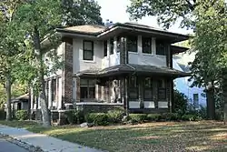 Chris Rye House |
January 29, 1980 (#80001438) |
630 E. State St. 43°09′04″N 93°11′36″W |
Mason City | |
| 34 | St. John Baptist Church | 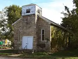 St. John Baptist Church |
January 24, 2002 (#01001484) |
715 6th St., SW. 43°08′46″N 93°12′45″W |
Mason City | |
| 35 | Charles Seney House | 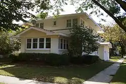 Charles Seney House |
January 29, 1980 (#80001439) |
109 7th St., NW. and 622 N. Washington St. 43°09′29″N 93°12′11″W |
Mason City | |
| 36 | C.P. Shipley House | January 29, 1980 (#80001440) |
114 3rd St., NW. 43°09′17″N 93°12′11″W |
Mason City | ||
| 37 | State Street Bridge | 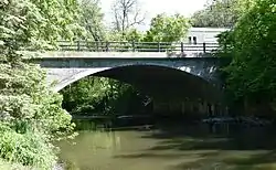 State Street Bridge |
June 25, 1998 (#98000740) |
E. State St. over Willow Creek 43°09′07″N 93°11′30″W |
Mason City | |
| 38 | Stewart Avenue Bridge | 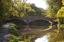 Stewart Avenue Bridge |
June 25, 1998 (#98000741) |
North Carolina Ave. over the Winnebago River 43°09′24″N 93°11′25″W |
Mason City | |
| 39 | Dr. G.C. Stockman House | 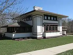 Dr. G.C. Stockman House |
September 17, 1992 (#80001441) |
311 1st St., SE. 43°09′09″N 93°11′32″W |
Mason City | |
| 40 | Surf Ballroom | Surf Ballroom |
September 6, 2011 (#10000261) |
460 N Shore Dr 43°08′24″N 93°23′22″W |
Clear Lake | |
| 41 | Wagner-Mozart Music Hall | November 16, 1978 (#78001210) |
1st St., NE. and Delaware Ave. 43°09′09″N 93°11′56″W |
Mason City | ||
| 42 | Winnebago River Bridge | 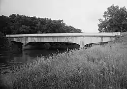 Winnebago River Bridge |
June 25, 1998 (#98000812) |
U.S. Route 65 over the Winnebago River 43°11′35″N 93°12′36″W |
Mason City | |
| 43 | Mier Wolf House | 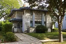 Mier Wolf House |
January 29, 1980 (#80001442) |
811 N. Adams St. 43°09′34″N 93°12′14″W |
Mason City | |
| 44 | Curtis Yelland House | 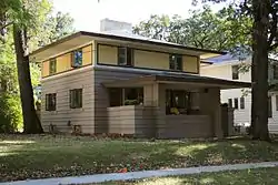 Curtis Yelland House |
January 29, 1980 (#80001443) |
37 River Heights Dr. 43°08′55″N 93°11′38″W |
Mason City | |
| 45 | Tessa Youngblood House | 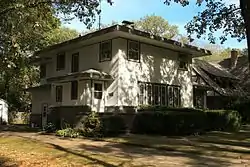 Tessa Youngblood House |
January 29, 1980 (#80001444) |
36 Oak Dr. 43°09′06″N 93°12′51″W |
Mason City |
See also
| Wikimedia Commons has media related to National Register of Historic Places in Cerro Gordo County, Iowa. |
References
- The latitude and longitude information provided in this table was derived originally from the National Register Information System, which has been found to be fairly accurate for about 99% of listings. Some locations in this table may have been corrected to current GPS standards.
- "National Register of Historic Places: Weekly List Actions". National Park Service, United States Department of the Interior. Retrieved on January 29, 2021.
- Numbers represent an alphabetical ordering by significant words. Various colorings, defined here, differentiate National Historic Landmarks and historic districts from other NRHP buildings, structures, sites or objects.
- "National Register Information System". National Register of Historic Places. National Park Service. April 24, 2008.
- The eight-digit number below each date is the number assigned to each location in the National Register Information System database, which can be viewed by clicking the number.
| Topics | |
|---|---|
| Lists by state |
|
| Lists by insular areas | |
| Lists by associated state | |
| Other areas | |
| Related | |
| |

Municipalities and communities of Cerro Gordo County, Iowa, United States | ||
|---|---|---|
| Cities | Map of Iowa highlighting Cerro Gordo County | |
| Townships | ||
| CDPs | ||
| Unincorporated communities | ||
| Footnotes | ‡This populated place also has portions in an adjacent county or counties | |
| ||
This article is issued from Wikipedia. The text is licensed under Creative Commons - Attribution - Sharealike. Additional terms may apply for the media files.