National Register of Historic Places listings in Appanoose County, Iowa
This is a list of the National Register of Historic Places listings in Appanoose County, Iowa.
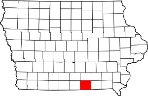
Location of Appanoose County in Iowa
This is intended to be a complete list of the properties and districts on the National Register of Historic Places in Appanoose County, Iowa, United States. Latitude and longitude coordinates are provided for many National Register properties and districts; these locations may be seen together in a map.[1]
There are 13 properties and districts listed on the National Register in the county.
- This National Park Service list is complete through NPS recent listings posted January 29, 2021.[2]
| [3] | Name on the Register[4] | Image | Date listed[5] | Location | City or town | Description |
|---|---|---|---|---|---|---|
| 1 | Appanoose County Courthouse | 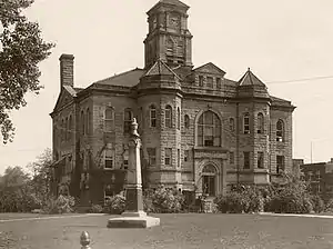 Appanoose County Courthouse |
July 2, 1981 (#81000225) |
Van Buren and N. 12th St. 40°44′02″N 92°52′28″W |
Centerville | |
| 2 | Appanoose County Sheriff's House and Jail | 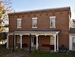 Appanoose County Sheriff's House and Jail |
October 30, 1997 (#97001292) |
527 N. Main St. 40°44′02″N 92°52′54″W |
Centerville | |
| 3 | CB&Q Passenger Depot | 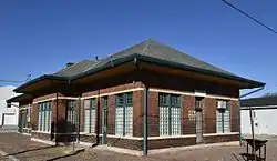 CB&Q Passenger Depot |
August 28, 2003 (#03000833) |
1124 S. 18th St. 40°43′24″N 92°52′05″W |
Centerville | |
| 4 | Courthouse Square Historic District | 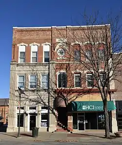 Courthouse Square Historic District |
October 30, 1997 (#97001291) |
Roughly bounded by Van Buren, Haynes, Maple, and 10th Sts. 40°44′01″N 92°52′23″W |
Centerville | |
| 5 | Drake Public Library |  Drake Public Library |
October 30, 1997 (#97001290) |
115 Drake Ave. 40°43′55″N 92°52′20″W |
Centerville | |
| 6 | Franklin Regular Baptist Church | February 20, 2008 (#08000087) |
135th Ave. and 590th St. 40°37′20″N 93°01′58″W |
Seymour | ||
| 7 | Porter Hall | 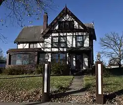 Porter Hall |
January 24, 1980 (#80001429) |
706 Drake Ave. 40°43′41″N 92°52′23″W |
Centerville | |
| 8 | Second Baptist Church | 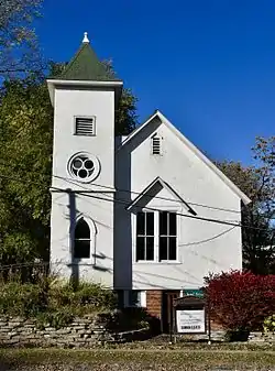 Second Baptist Church |
October 14, 1999 (#99001223) |
422 S. 18th St. 40°43′47″N 92°52′05″W |
Centerville | |
| 9 | Stratton House | 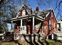 Stratton House |
September 9, 1975 (#75000677) |
303 E. Washington St. 40°44′10″N 92°52′18″W |
Centerville | |
| 10 | Sturdivant-Sawyer House | 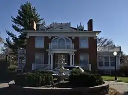 Sturdivant-Sawyer House |
January 12, 1984 (#84001202) |
707 Drake Ave. 40°43′41″N 92°52′20″W |
Centerville | |
| 11 | U.S. Post Office | 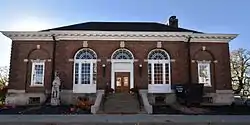 U.S. Post Office |
November 7, 1978 (#78001204) |
100 W. Maple St. 40°43′56″N 92°52′28″W |
Centerville | |
| 12 | Vermilion Estate | April 26, 1978 (#78001205) |
Valley Dr. 40°43′39″N 92°53′29″W |
Centerville | ||
| 13 | Wabash Combination Depot-Moravia | October 18, 1996 (#96001158) |
W. North St. near its junction with Brandon St. 40°53′31″N 92°49′29″W |
Moravia |
See also
| Wikimedia Commons has media related to National Register of Historic Places in Appanoose County, Iowa. |
References
- The latitude and longitude information provided in this table was derived originally from the National Register Information System, which has been found to be fairly accurate for about 99% of listings. Some locations in this table may have been corrected to current GPS standards.
- "National Register of Historic Places: Weekly List Actions". National Park Service, United States Department of the Interior. Retrieved on January 29, 2021.
- Numbers represent an alphabetical ordering by significant words. Various colorings, defined here, differentiate National Historic Landmarks and historic districts from other NRHP buildings, structures, sites or objects.
- "National Register Information System". National Register of Historic Places. National Park Service. April 24, 2008.
- The eight-digit number below each date is the number assigned to each location in the National Register Information System database, which can be viewed by clicking the number.
| Topics | |
|---|---|
| Lists by state |
|
| Lists by insular areas | |
| Lists by associated state | |
| Other areas | |
| Related | |
| |

Municipalities and communities of Appanoose County, Iowa, United States | ||
|---|---|---|
| Cities | Map of Iowa highlighting Appanoose County | |
| Townships | ||
| Unincorporated communities | ||
| ||
This article is issued from Wikipedia. The text is licensed under Creative Commons - Attribution - Sharealike. Additional terms may apply for the media files.