National Register of Historic Places listings in Lucas County, Iowa
This is a list of the National Register of Historic Places listings in Lucas County, Iowa.
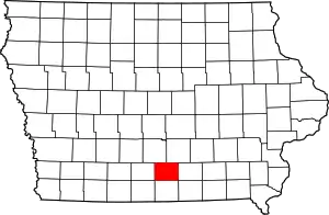
Location of Lucas County in Iowa
This is intended to be a complete list of the properties and districts on the National Register of Historic Places in Lucas County, Iowa, United States. Latitude and longitude coordinates are provided for many National Register properties and districts; these locations may be seen together in a map.[1]
There are 16 properties listed on the National Register in the county.
- This National Park Service list is complete through NPS recent listings posted February 5, 2021.[2]
| [3] | Name on the Register[4] | Image | Date listed[5] | Location | City or town | Description |
|---|---|---|---|---|---|---|
| 1 | Burlington Railroad Overpass | May 15, 1998 (#98000511) |
County Road S23 over the Burlington Northern railroad line 41°02′27″N 93°21′57″W |
Chariton | ||
| 2 | Carl L. Caviness Post 102, American Legion | 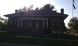 Carl L. Caviness Post 102, American Legion |
September 6, 2006 (#06000773) |
201 S. Main St. 41°00′47″N 93°18′31″W |
Chariton | |
| 3 | Chariton Cemetery Historic District |  Chariton Cemetery Historic District |
March 2, 2010 (#10000054) |
929 S. Main St. 41°00′10″N 93°18′38″W |
Chariton | |
| 4 | Chariton City Hall and Fire Station | 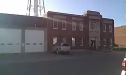 Chariton City Hall and Fire Station |
September 6, 2006 (#06000775) |
115 S. Main St. 41°00′50″N 93°18′31″W |
Chariton | |
| 5 | Chariton Free Public Library | 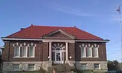 Chariton Free Public Library |
August 24, 2005 (#05000906) |
803 Braden 41°00′57″N 93°18′20″W |
Chariton | |
| 6 | Chariton Herald-Patriot Building |  Chariton Herald-Patriot Building |
September 6, 2006 (#06000776) |
815 Braden Ave. 41°00′57″N 93°18′22″W |
Chariton | |
| 7 | Chariton Masonic Temple | 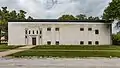 Chariton Masonic Temple |
September 6, 2006 (#06000777) |
821 Armory Ave. 41°00′45″N 93°18′23″W |
Chariton | |
| 8 | Chicago, Burlington, and Quincy Freight House-Chariton | 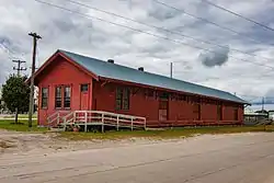 Chicago, Burlington, and Quincy Freight House-Chariton |
August 28, 2003 (#03000836) |
Junction of Auburn and Brookdale 41°01′07″N 93°18′38″W |
Chariton | |
| 9 | J. T. and Mollie Crozier House | 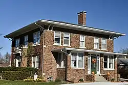 J. T. and Mollie Crozier House |
October 6, 2011 (#11000721) |
627 Ilion Ave. 41°01′31″N 93°18′11″W |
Chariton | Architectural Career of William L. Perkins in Iowa: 1917-1957 MPS |
| 10 | First United Methodist Church | 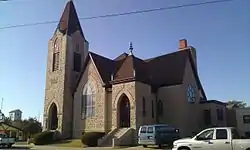 First United Methodist Church |
January 24, 2002 (#01001485) |
923 Roland 41°01′01″N 93°18′29″W |
Chariton | |
| 11 | Hotel Charitone | 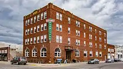 Hotel Charitone |
September 6, 2006 (#06000774) |
831 Braden Ave. 41°00′57″N 93°18′23″W |
Chariton | |
| 12 | Lucas County Courthouse | 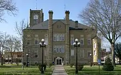 Lucas County Courthouse |
July 2, 1981 (#81000254) |
Courthouse Sq. 41°00′54″N 93°18′27″W |
Chariton | |
| 13 | Lucas County Courthouse Square Historic District | 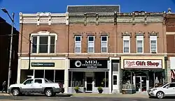 Lucas County Courthouse Square Historic District |
August 11, 2014 (#14000324) |
Braden and Court avenues and Grand and Main streets around the public square 41°00′54″N 93°18′27″W |
Chariton | |
| 14 | O. E. Payne House | 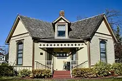 O. E. Payne House |
July 17, 1979 (#79000912) |
705 E. Auburn Ave. 41°01′06″N 93°18′14″W |
Chariton | |
| 15 | A. J. Stephens House | 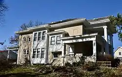 A. J. Stephens House |
November 16, 1987 (#87002020) |
123 17th St. 41°00′56″N 93°19′11″W |
Chariton | |
| 16 | Williamson School | 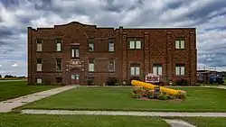 Williamson School |
May 1, 1998 (#98000374) |
301 Williamson Ave. 41°05′22″N 93°15′36″W |
Williamson |
See also
| Wikimedia Commons has media related to National Register of Historic Places in Lucas County, Iowa. |
References
- The latitude and longitude information provided in this table was derived originally from the National Register Information System, which has been found to be fairly accurate for about 99% of listings. Some locations in this table may have been corrected to current GPS standards.
- "National Register of Historic Places: Weekly List Actions". National Park Service, United States Department of the Interior. Retrieved on February 5, 2021.
- Numbers represent an alphabetical ordering by significant words. Various colorings, defined here, differentiate National Historic Landmarks and historic districts from other NRHP buildings, structures, sites or objects.
- "National Register Information System". National Register of Historic Places. National Park Service. April 24, 2008.
- The eight-digit number below each date is the number assigned to each location in the National Register Information System database, which can be viewed by clicking the number.
| Topics | |
|---|---|
| Lists by state |
|
| Lists by insular areas | |
| Lists by associated state | |
| Other areas | |
| Related | |
| |

Municipalities and communities of Lucas County, Iowa, United States | ||
|---|---|---|
| Cities | Map of Iowa highlighting Lucas County | |
| Townships | ||
| Unincorporated communities | ||
| ||
This article is issued from Wikipedia. The text is licensed under Creative Commons - Attribution - Sharealike. Additional terms may apply for the media files.