National Register of Historic Places listings in Bremer County, Iowa
This is a list of the National Register of Historic Places listings in Bremer County, Iowa.
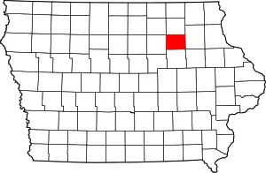
Location of Bremer County in Iowa
This is intended to be a complete list of the properties and districts on the National Register of Historic Places in Bremer County, Iowa, United States. Latitude and longitude coordinates are provided for many National Register properties and districts; these locations may be seen together in a map.[1]
There are 12 properties and districts listed on the National Register in the county.
- This National Park Service list is complete through NPS recent listings posted January 29, 2021.[2]
Current listings
| [3] | Name on the Register[4] | Image | Date listed[5] | Location | City or town | Description |
|---|---|---|---|---|---|---|
| 1 | Bank of Sumner | 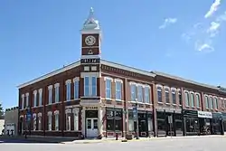 Bank of Sumner |
August 25, 2004 (#04000900) |
118 W. 1st St. 42°50′58″N 92°05′55″W |
Sumner | |
| 2 | Bremer County Court House |  Bremer County Court House |
August 28, 2003 (#03000821) |
415 E. Bremer Ave. 42°43′34″N 92°27′54″W |
Waverly | |
| 3 | Harmon and LeValley Northwest Historic District | 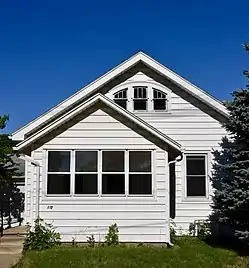 Harmon and LeValley Northwest Historic District |
June 6, 2014 (#14000284) |
Roughly Cedar River, 1st, 7th and 6th Avenues NW 42°43′43″N 92°28′20″W |
Waverly | |
| 4 | Old Fourth Ward Southeast Historic District | 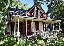 Old Fourth Ward Southeast Historic District |
December 18, 2013 (#13000922) |
Roughly bounded by the Cedar River, 2nd and 3rd Avenues SE, and 4th Street SE 42°43′24″N 92°28′05″W |
Waverly | |
| 5 | Sturdevant Southwest Historic District | 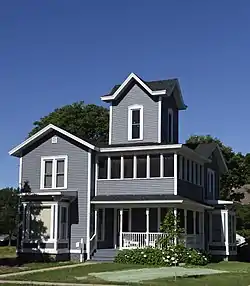 Sturdevant Southwest Historic District |
May 16, 2016 (#16000248) |
Roughly bounded by 1st & 8th Sts. SW, 1st & 5th Aves. SW, W. Bremer Ave., and Cedar River 42°43′24″N 92°28′32″W |
Waverly | |
| 6 | Sumner High School | .jpg.webp) Sumner High School |
June 16, 2004 (#04000597) |
300 W. 4th 42°51′03″N 92°06′04″W |
Sumner | |
| 7 | Third Street Bridge (FHWA No. 012250) | May 31, 2018 (#100002485) |
3rd St SE over the Cedar R. between 5th & 6th Aves SE 42°43′15″N 92°28′01″W |
Waverly | ||
| 8 | Wartburg Teachers' Seminary | 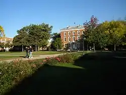 Wartburg Teachers' Seminary |
January 20, 1978 (#78001208) |
Wartburg College campus 42°43′46″N 92°28′54″W |
Waverly | |
| 9 | Waverly East Bremer Avenue Commercial Historic District | 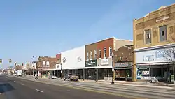 Waverly East Bremer Avenue Commercial Historic District |
April 24, 2014 (#14000174) |
E. Bremer Ave. 42°43′33″N 92°28′08″W |
Waverly | |
| 10 | Waverly House | 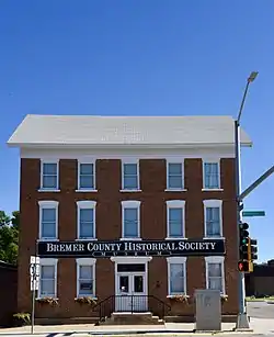 Waverly House |
December 12, 1976 (#76000735) |
402 W. Bremer Ave. 42°43′33″N 92°28′33″W |
Waverly | |
| 11 | Waverly Municipal Hydroelectric Powerhouse | 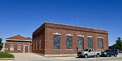 Waverly Municipal Hydroelectric Powerhouse |
December 18, 2013 (#13000923) |
121 1st Street, NE 42°43′36″N 92°28′12″W |
Waverly |
Former listings
| [3] | Name on the Register | Image | Date listed | Date removed | Location | City or town | Summary |
|---|---|---|---|---|---|---|---|
| 1 | Green Mill Ford Bridge | August 28, 2003 (#98000760) | June 25, 1998 | County road over the Cedar River 42°40′20″N 92°25′44″W |
Janesville | Destroyed by a flood in 2019.[6] | |
| 2 | Octagon Barn | June 30, 1986 (#86001418) | April 29, 1993 | East of US 218 |
Plainfield vicinity |
See also
| Wikimedia Commons has media related to National Register of Historic Places in Bremer County, Iowa. |
References
- The latitude and longitude information provided in this table was derived originally from the National Register Information System, which has been found to be fairly accurate for about 99% of listings. Some locations in this table may have been corrected to current GPS standards.
- "National Register of Historic Places: Weekly List Actions". National Park Service, United States Department of the Interior. Retrieved on January 29, 2021.
- Numbers represent an alphabetical ordering by significant words. Various colorings, defined here, differentiate National Historic Landmarks and historic districts from other NRHP buildings, structures, sites or objects.
- "National Register Information System". National Register of Historic Places. National Park Service. July 9, 2010.
- The eight-digit number below each date is the number assigned to each location in the National Register Information System database, which can be viewed by clicking the number.
- Tim Jamison (March 19, 2019). "Parts of missing Janesville bridge found (PHOTOS)". The Waterloo-Cedar Falls Courier. Waterloo. Retrieved 2019-09-22.
| Topics | |
|---|---|
| Lists by state |
|
| Lists by insular areas | |
| Lists by associated state | |
| Other areas | |
| Related | |
| |

Municipalities and communities of Bremer County, Iowa, United States | ||
|---|---|---|
| Cities | Map of Iowa highlighting Bremer County | |
| Townships | ||
| Unincorporated communities |
| |
| Footnotes | ‡This populated place also has portions in an adjacent county or counties | |
| ||
This article is issued from Wikipedia. The text is licensed under Creative Commons - Attribution - Sharealike. Additional terms may apply for the media files.