National Register of Historic Places listings in Adair County, Iowa
This is a list of the National Register of Historic Places listings in Adair County, Iowa.
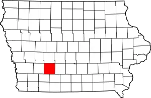
Location of Adair County in Iowa
This is intended to be a complete list of the properties and districts on the National Register of Historic Places in Adair County, Iowa, United States. Latitude and longitude coordinates are provided for many National Register properties and districts; these locations may be seen together in a map.[1]
There are 9 properties and districts listed on the National Register in the county.
- This National Park Service list is complete through NPS recent listings posted February 5, 2021.[2]
Current listings
| [3] | Name on the Register[4] | Image | Date listed[5] | Location | City or town | Description |
|---|---|---|---|---|---|---|
| 1 | Adair County Courthouse | 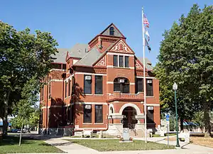 Adair County Courthouse |
July 2, 1981 (#81000224) |
Iowa Ave. and 1st St. 41°18′18″N 94°27′40″W |
Greenfield | Romanesque Revival style brick courthouse built in 1891.[6] |
| 2 | Adair County Democrat-Adair County Free Press Building | February 7, 2011 (#10001203) |
108 E. Iowa St. 41°18′18″N 94°27′36″W |
Greenfield | ||
| 3 | Adair Viaduct |  Adair Viaduct |
June 25, 1998 (#98000775) |
Business Route 80 over the Iowa Interstate Railroad tracks 41°29′50″N 94°38′36″W |
Adair | A ribbed open spandrel type of arch bridge spanning 80 feet.[7] |
| 4 | Catalpa | 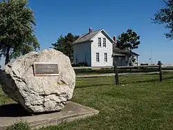 Catalpa |
November 13, 1974 (#74000776) |
Southeast of Greenfield 41°13′55″N 94°21′37″W |
Greenfield | Also known as Wallace Farm, this farm was once owned by Henry Cantwell Wallace, American farmer, journalist, and political activist.[8] |
| 5 | Chicago, Rock Island and Pacific Railroad: Stuart Passenger Station | 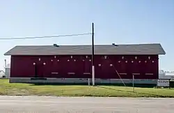 Chicago, Rock Island and Pacific Railroad: Stuart Passenger Station |
February 19, 1980 (#80001428) |
Front St. 41°30′12″N 94°19′01″W |
Stuart | |
| 6 | Greenfield Public Square Historic District | September 17, 2014 (#14000623) |
102–362 Public Square, 201–215 S. 1st St., 107–110 E. Iowa St. 41°18′18″N 94°27′40″W |
Greenfield | ||
| 7 | Hotel Greenfield | 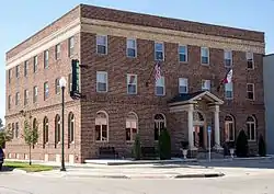 Hotel Greenfield |
November 18, 2011 (#11000812) |
110 E. Iowa St. 41°18′18″N 94°27′35″W |
Greenfield | |
| 8 | Loucks Grove Church | November 22, 1995 (#95001314) |
7 miles north of the junction of Iowa Highways 25 and 92, then 3 miles east and 1.5 miles north on an unnamed county road 41°25′30″N 94°23′40″W |
Greenfield | ||
| 9 | Warren Opera House Block and Hetherington Block | 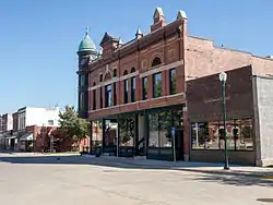 Warren Opera House Block and Hetherington Block |
October 18, 1979 (#79000880) |
156 Public Sq. 41°18′18″N 94°27′37″W |
Greenfield |
See also
| Wikimedia Commons has media related to National Register of Historic Places in Adair County, Iowa. |
References
- The latitude and longitude information provided in this table was derived originally from the National Register Information System, which has been found to be fairly accurate for about 99% of listings. Some locations in this table may have been corrected to current GPS standards.
- "National Register of Historic Places: Weekly List Actions". National Park Service, United States Department of the Interior. Retrieved on February 5, 2021.
- Numbers represent an alphabetical ordering by significant words. Various colorings, defined here, differentiate National Historic Landmarks and historic districts from other NRHP buildings, structures, sites or objects.
- "National Register Information System". National Register of Historic Places. National Park Service. July 9, 2010.
- The eight-digit number below each date is the number assigned to each location in the National Register Information System database, which can be viewed by clicking the number.
- "Adair County Courthouse". National Park Service Focus. Retrieved 29 September 2015.
- "Adair Viaduct". National Park Service Focus. Retrieved 29 September 2015.
- "Catalpa". National Park Service Focus. Retrieved 29 September 2015.
| Topics | |
|---|---|
| Lists by state |
|
| Lists by insular areas | |
| Lists by associated state | |
| Other areas | |
| Related | |
| |

Municipalities and communities of Adair County, Iowa, United States | ||
|---|---|---|
| Cities | Map of Iowa highlighting Adair County | |
| Townships | ||
| Unincorporated communities | ||
| Footnotes | ‡This populated place also has portions in an adjacent county or counties | |
| ||
This article is issued from Wikipedia. The text is licensed under Creative Commons - Attribution - Sharealike. Additional terms may apply for the media files.