National Register of Historic Places listings in Dallas County, Iowa
This is a list of the National Register of Historic Places listings in Dallas County, Iowa.
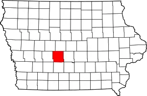
Location of Dallas County in Iowa
This is intended to be a complete list of the properties and districts on the National Register of Historic Places in Dallas County, Iowa, United States. Latitude and longitude coordinates are provided for many National Register properties and districts; these locations may be seen together in a map.[1]
There are 15 properties and districts listed on the National Register in the county. Another property was once listed but has been removed.
- This National Park Service list is complete through NPS recent listings posted January 29, 2021.[2]
Current listings
| [3] | Name on the Register[4] | Image | Date listed[5] | Location | City or town | Description |
|---|---|---|---|---|---|---|
| 1 | Adel Bridge | 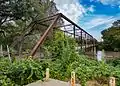 Adel Bridge |
April 18, 2002 (#02000374) |
River St. 41°36′57″N 94°00′43″W |
Adel | |
| 2 | Adel Public Square Historic District | 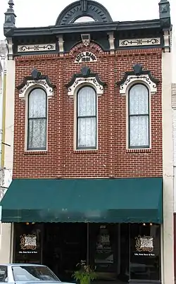 Adel Public Square Historic District |
December 18, 2009 (#09000106) |
About four blocks in downtown Adel centered on the public square 41°37′04″N 94°01′05″W |
Adel | |
| 3 | Beaver Creek Bridge | June 25, 1998 (#98000796) |
M Ave. over Beaver Creek 41°50′47″N 94°02′53″W |
Perry | ||
| 4 | Bruce's Snowball Market No. 1 Addition | 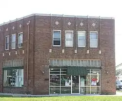 Bruce's Snowball Market No. 1 Addition |
September 8, 2000 (#00001004) |
921 Railroad St. 41°50′15″N 94°06′17″W |
Perry | |
| 5 | Dallas County Courthouse | 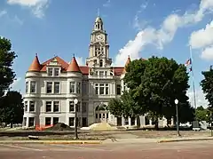 Dallas County Courthouse |
November 26, 1973 (#73000723) |
Town Sq. 41°37′04″N 94°01′03″W |
Adel | |
| 6 | Dexter Community House | 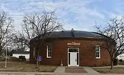 Dexter Community House |
March 3, 1975 (#75000679) |
707 Dallas St. 41°31′01″N 94°13′36″W |
Dexter | |
| 7 | Downtown Perry Historic District | 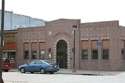 Downtown Perry Historic District |
September 8, 2000 (#00001005) |
Between 3rd St., Lucinda St., 1st Ave., and Railroad St. 41°50′24″N 94°06′14″W |
Perry | |
| 8 | Robert William Andrew Feller Farmstead | 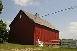 Robert William Andrew Feller Farmstead |
December 17, 1999 (#99001570) |
2965 340th Tr. 41°32′45″N 93°54′29″W |
Van Meter | |
| 9 | Jones Business College | 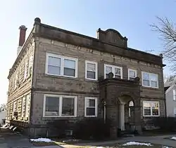 Jones Business College |
November 30, 2000 (#00001006) |
1305 Otley Ave. 41°50′15″N 94°06′12″W |
Perry | |
| 10 | Anthony M. McColl House | 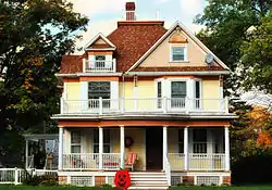 Anthony M. McColl House |
February 5, 1987 (#87000026) |
502 S. Main St. 41°51′12″N 93°55′19″W |
Woodward | |
| 11 | Minburn Railroad Depot | Minburn Railroad Depot |
December 7, 2015 (#15000863) |
210 4th St. 41°45′18″N 94°01′42″W |
Minburn | |
| 12 | Perry Carnegie Library Building | 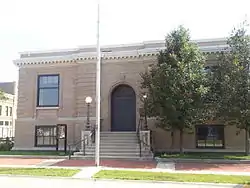 Perry Carnegie Library Building |
October 3, 1996 (#96001061) |
1123 Willis Ave. 41°50′18″N 94°06′18″W |
Perry | |
| 13 | Prairie Center Methodist Episcopal Church and Pleasand Hill Cemetery | 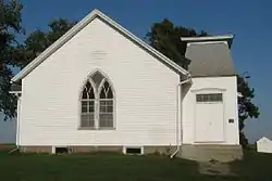 Prairie Center Methodist Episcopal Church and Pleasand Hill Cemetery |
October 12, 2004 (#04001141) |
Beaumont Ave. and 200th St. 41°44′45″N 94°15′02″W |
Yale | |
| 14 | St. Patrick's Catholic Church and Rectory | 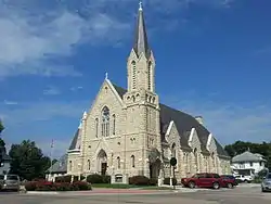 St. Patrick's Catholic Church and Rectory |
March 22, 2011 (#11000138) |
1312 Third St. 41°50′27″N 94°06′12″W |
Perry | |
| 15 | John Wilson House | March 30, 1979 (#79000894) |
Southwest of De Soto 41°30′30″N 94°05′33″W |
De Soto |
Former listing
| [3] | Name on the Register | Image | Date listed | Date removed | Location | City or town | Summary |
|---|---|---|---|---|---|---|---|
| 1 | Mosher Building | January 25, 1991 (#90002192) | May 22, 1998 | 1017 Railroad |
Perry | ||
| 2 | Perry Volunteer Fire Department Engine House | November 7, 1978 (#78001212) | Unknown | 1208 1st St. |
Perry |
See also
| Wikimedia Commons has media related to National Register of Historic Places in Dallas County, Iowa. |
References
- The latitude and longitude information provided in this table was derived originally from the National Register Information System, which has been found to be fairly accurate for about 99% of listings. Some locations in this table may have been corrected to current GPS standards.
- "National Register of Historic Places: Weekly List Actions". National Park Service, United States Department of the Interior. Retrieved on January 29, 2021.
- Numbers represent an alphabetical ordering by significant words. Various colorings, defined here, differentiate National Historic Landmarks and historic districts from other NRHP buildings, structures, sites or objects.
- "National Register Information System". National Register of Historic Places. National Park Service. April 24, 2008.
- The eight-digit number below each date is the number assigned to each location in the National Register Information System database, which can be viewed by clicking the number.
| Topics | |
|---|---|
| Lists by state |
|
| Lists by insular areas | |
| Lists by associated state | |
| Other areas | |
| Related | |
| |

Municipalities and communities of Dallas County, Iowa, United States | ||
|---|---|---|
| Cities | Map of Iowa highlighting Dallas County | |
| Townships | ||
| Unincorporated communities | ||
| Footnotes | ‡This populated place also has portions in an adjacent county or counties | |
| ||
This article is issued from Wikipedia. The text is licensed under Creative Commons - Attribution - Sharealike. Additional terms may apply for the media files.