National Register of Historic Places listings in Marshall County, Iowa
This is a list of the National Register of Historic Places listings in Marshall County, Iowa.
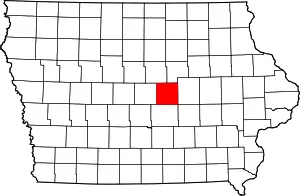
Location of Marshall County in Iowa
This is intended to be a complete list of the properties and districts on the National Register of Historic Places in Marshall County, Iowa, United States. Latitude and longitude coordinates are provided for many National Register properties and districts; these locations may be seen together in a map.[1]
There are 15 properties and districts listed on the National Register in the county. Another property was once listed but has been removed.
- This National Park Service list is complete through NPS recent listings posted January 29, 2021.[2]
| [3] | Name on the Register[4] | Image | Date listed[5] | Location | City or town | Description |
|---|---|---|---|---|---|---|
| 1 | Thaddeus Binford House | 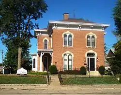 Thaddeus Binford House |
January 12, 1984 (#84001286) |
110 N. 2nd Ave. 42°03′04″N 92°54′34″W |
Marshalltown | |
| 2 | Dobbin Round Barn | 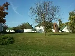 Dobbin Round Barn |
June 30, 1986 (#86001459) |
Off County Road S52 41°59′06″N 93°11′58″W |
State Center | |
| 3 | Matthew Edel Blacksmith Shop and House | 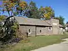 Matthew Edel Blacksmith Shop and House |
March 11, 1983 (#83000391) |
1st St. and 3rd Ave. 41°56′42″N 92°57′40″W |
Haverhill | |
| 4 | Glick-Sower House | 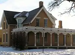 Glick-Sower House |
April 22, 1993 (#93000331) |
201 E. State St. 42°03′00″N 92°54′33″W |
Marshalltown | |
| 5 | Le Grand Bridge (1896) | May 15, 1998 (#98000481) |
Abbot Ave. over the Iowa River 42°01′54″N 92°45′58″W |
Le Grand, in both Marshall and Tama counties | Profile from the Iowa Department of Transportation | |
| 6 | Le Grand Bridge (1914) | .jpg.webp) Le Grand Bridge (1914) |
May 15, 1998 (#98000499) |
County Road T37 over a backwater of the Iowa River 42°01′47″N 92°46′59″W |
Le Grand | |
| 7 | Marshall County Courthouse | 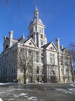 Marshall County Courthouse |
November 21, 1972 (#72000478) |
Courthouse Sq. 42°02′55″N 92°54′42″W |
Marshalltown | |
| 8 | Marshalltown Downtown Historic District | 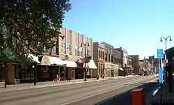 Marshalltown Downtown Historic District |
January 17, 2002 (#01001463) |
Roughly bounded by 2nd St., State St., 3rd. Ave., and E. Church St. 42°02′57″N 92°54′48″W |
Marshalltown | |
| 9 | Minerva Creek Bridge | May 15, 1998 (#98000497) |
County Road S52 over Minerva Creek 42°08′21″N 93°09′21″W |
Clemons | ||
| 10 | Quarry Bridge | 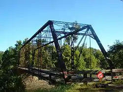 Quarry Bridge |
May 15, 1998 (#98000498) |
County Road I-4 over the Iowa River 42°01′35″N 92°48′29″W |
Marshalltown | |
| 11 | State Center Commercial Historic District | September 20, 2002 (#02001034) |
Blocks 200 and 100 of W. Main St. and 100 E. Main St. 42°00′58″N 93°09′51″W |
State Center | ||
| 12 | Robert H. Sunday House | 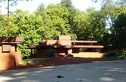 Robert H. Sunday House |
November 9, 1988 (#88002141) |
1701 Woodfield Rd. 42°01′36″N 92°55′40″W |
Marshalltown | |
| 13 | Watson's Grocery | 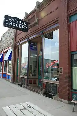 Watson's Grocery |
October 22, 1998 (#98001271) |
106 Main St. 42°00′59″N 93°09′50″W |
State Center | |
| 14 | C.H. Whitehead House | 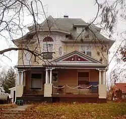 C.H. Whitehead House |
January 15, 1979 (#79000916) |
108 N. 3rd St. 42°02′57″N 92°55′22″W |
Marshalltown | |
| 15 | Leroy R. Willard House | 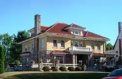 Leroy R. Willard House |
October 22, 1976 (#76000794) |
609 W. Main St. 42°02′57″N 92°55′22″W |
Marshalltown |
Former listing
| [3] | Name on the Register | Image | Date listed | Date removed | Location | City or town | Summary |
|---|---|---|---|---|---|---|---|
| 1 | First Church of Christ, Scientist | 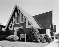 First Church of Christ, Scientist |
1979 (#79000915) | May 22, 1998 | 412W. Main St. |
Marshalltown |
See also
| Wikimedia Commons has media related to National Register of Historic Places in Marshall County, Iowa. |
References
- The latitude and longitude information provided in this table was derived originally from the National Register Information System, which has been found to be fairly accurate for about 99% of listings. Some locations in this table may have been corrected to current GPS standards.
- "National Register of Historic Places: Weekly List Actions". National Park Service, United States Department of the Interior. Retrieved on January 29, 2021.
- Numbers represent an alphabetical ordering by significant words. Various colorings, defined here, differentiate National Historic Landmarks and historic districts from other NRHP buildings, structures, sites or objects.
- "National Register Information System". National Register of Historic Places. National Park Service. April 24, 2008.
- The eight-digit number below each date is the number assigned to each location in the National Register Information System database, which can be viewed by clicking the number.
| Topics | |
|---|---|
| Lists by state |
|
| Lists by insular areas | |
| Lists by associated state | |
| Other areas | |
| Related | |
| |

Municipalities and communities of Marshall County, Iowa, United States | ||
|---|---|---|
| Cities | Map of Iowa highlighting Marshall County | |
| Townships | ||
| CDP | ||
| Other unincorporated communities | ||
| Footnotes | ‡This populated place also has portions in an adjacent county or counties | |
| ||
This article is issued from Wikipedia. The text is licensed under Creative Commons - Attribution - Sharealike. Additional terms may apply for the media files.