National Register of Historic Places listings in Clayton County, Iowa
This is a list of the National Register of Historic Places listings in Clayton County, Iowa.
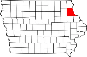
Location of Clayton County in Iowa
This is intended to be a complete list of the properties and districts on the National Register of Historic Places in Clayton County, Iowa, United States. Latitude and longitude coordinates are provided for many National Register properties and districts; these locations may be seen together in a map.[1]
There are 55 properties and districts listed on the National Register in the county. Another two properties were once listed but have been removed.
- This National Park Service list is complete through NPS recent listings posted February 5, 2021.[2]
Current listings
| [3] | Name on the Register[4] | Image | Date listed[5] | Location | City or town | Description |
|---|---|---|---|---|---|---|
| 1 | Albertus Building | 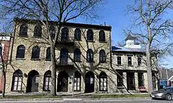 Albertus Building |
April 26, 1979 (#79000891) |
222 Park River Dr. 42°47′03″N 91°05′47″W |
Guttenberg | |
| 2 | American House | 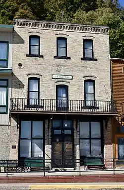 American House |
August 30, 2001 (#01000913) |
116 Main St. 43°01′33″N 91°10′26″W |
McGregor | |
| 3 | American School of Wild Life Protection Historic District | December 23, 1991 (#91001840) |
McGregor Heights Rd., north of McGregor 43°01′43″N 91°10′33″W |
McGregor | ||
| 4 | Christian Bloedel Wagon Works | 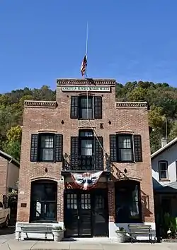 Christian Bloedel Wagon Works |
September 23, 2009 (#09000765) |
524-526 Main St. 43°01′14″N 91°10′49″W |
McGregor | |
| 5 | Carter House | 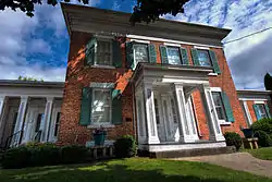 Carter House |
November 7, 1976 (#76000744) |
101 High St., SE. 42°51′19″N 91°24′09″W |
Elkader | |
| 6 | Clayton County Courthouse | 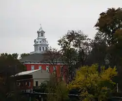 Clayton County Courthouse |
October 8, 1976 (#76000745) |
111 High St. 42°51′19″N 91°24′12″W |
Elkader | |
| 7 | Clayton School |  Clayton School |
July 30, 1974 (#74000778) |
1st St. 42°54′09″N 91°08′45″W |
Clayton | |
| 8 | Timothy Davis House |  Timothy Davis House |
June 22, 1976 (#76000746) |
405 1st St., NW. 42°51′23″N 91°24′30″W |
Elkader | |
| 9 | Dry Run Bridge | June 25, 1998 (#98000803) |
Local street over Dry Run 42°45′10″N 91°22′08″W |
Littleport | ||
| 10 | Eckert House | September 24, 1984 (#84001216) |
413 S. 1st St. 42°46′55″N 91°05′45″W |
Guttenberg | ||
| 11 | Effigy Mounds National Monument |  Effigy Mounds National Monument |
October 15, 1966 (#66000109) |
3 miles north of Marquette on Iowa Highway 76 43°03′52″N 91°10′50″W |
Marquette | Extends into Allamakee County |
| 12 | Elkader Downtown Historic District |  Elkader Downtown Historic District |
March 13, 2012 (#12000095) |
Portions of the 100 & 200 blocks of Main St. & side streets 42°51′16″N 91°24′16″W |
Elkader | Elkader Downtown Multiple Property Submission |
| 13 | Elkader Keystone Bridge | 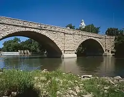 Elkader Keystone Bridge |
November 7, 1976 (#76000747) |
Bridge St. 42°51′17″N 91°24′13″W |
Elkader | |
| 14 | Elkader Opera House | 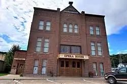 Elkader Opera House |
October 8, 1976 (#76000748) |
207 N. Main 42°51′19″N 91°24′20″W |
Elkader | |
| 15 | Farmers' State Bank |  Farmers' State Bank |
September 24, 2018 (#100002983) |
502 Washington St. 42°48′11″N 91°32′28″W |
Volga | |
| 15 | First Congregational Church | 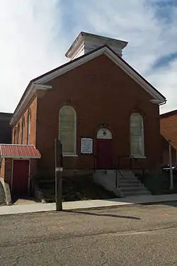 First Congregational Church |
March 25, 1977 (#77000504) |
Washington St. 42°52′06″N 91°14′16″W |
Garnavillo | |
| 16 | Franklin Hotel |  Franklin Hotel |
June 25, 1999 (#99000740) |
102 Elkader St. 42°41′01″N 91°32′02″W |
Strawberry Point | |
| 17 | Front Street (River Park Drive) Historic District |  Front Street (River Park Drive) Historic District |
September 24, 1984 (#84001222) |
River Park Dr. between Lessing and Pearl Sts.; also S. 1st, Prince, Goethe, Herder, and Schiller Sts. 42°46′56″N 91°05′42″W |
Guttenberg | Second set of addresses represents a boundary increase |
| 18 | Fuerste House | 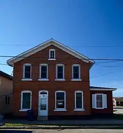 Fuerste House |
September 24, 1984 (#84001223) |
503 S. 1st St. 42°46′54″N 91°05′45″W |
Guttenberg | |
| 19 | Garnavillo Township Bridge | June 25, 1998 (#98000807) |
County road over an unnamed stream 42°51′47″N 91°16′57″W |
Garnavillo Township | ||
| 20 | Garnavillo Township Culvert | June 25, 1998 (#98000805) |
County road over an unnamed stream 42°52′04″N 91°16′10″W |
Garnavillo Township | One of seven stone limestone arch bridges built in 1900. | |
| 21 | Goedert Meat Market | 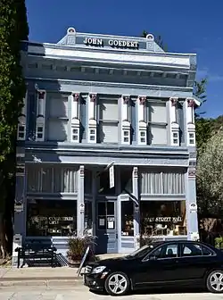 Goedert Meat Market |
October 18, 1996 (#96001159) |
322 Main St. 43°01′22″N 91°10′40″W |
McGregor | Italianate influenced commercial building with the only complete cast-iron storefront in McGregor. |
| 22 | Guttenberg Corn Canning Co. | 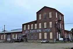 Guttenberg Corn Canning Co. |
September 24, 1984 (#84001226) |
413 N. 3rd St. 42°47′18″N 91°06′05″W |
Guttenberg | |
| 23 | Guttenberg National Fish Hatchery and Aquarium Historic District | 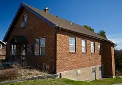 Guttenberg National Fish Hatchery and Aquarium Historic District |
December 23, 1991 (#91001833) |
315 S. River Park Dr. 42°47′01″N 91°05′41″W |
Guttenberg | |
| 24 | Guttenberg State Bank | 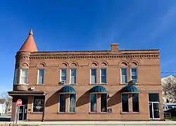 Guttenberg State Bank |
September 24, 1984 (#84001228) |
15 Goethe St. 42°46′59″N 91°05′47″W |
Guttenberg | |
| 25 | I.O.O.F. Hall |  I.O.O.F. Hall |
June 18, 1979 (#79000890) |
Centre St. 42°52′05″N 91°14′10″W |
Garnavillo | |
| 26 | Kolker House | 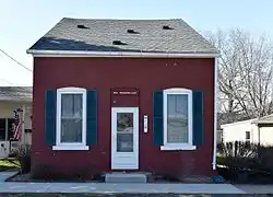 Kolker House |
September 24, 1984 (#84001230) |
110 Goethe St. 42°46′58″N 91°06′35″W |
Guttenberg | |
| 27 | Lakeside Ballroom | 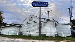 Lakeside Ballroom |
February 4, 2002 (#01001539) |
1202 N. 4th St. 42°46′22″N 91°06′00″W |
Guttenberg | |
| 28 | Mallory Township Bridge | June 25, 1998 (#98000809) |
County road over an unnamed stream 42°43′08″N 91°10′42″W |
Mallory Township | Bridge distinguished as the oldest remaining example of the Pratt half-hip pony truss in Iowa, built in 1890. | |
| 29 | Matt-Bahls House | 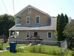 Matt-Bahls House |
September 24, 1984 (#84001232) |
615 S. 3rd St. 42°46′24″N 91°05′53″W |
Guttenberg | |
| 30 | McClaine House | September 24, 1984 (#84001234) |
300 S. 1st St. 42°47′03″N 91°05′50″W |
Guttenberg | ||
| 31 | McGregor Commercial Historic District | McGregor Commercial Historic District |
December 10, 2002 (#02001033) |
100-300 blocks of Main St. and the 100 and 200 blocks of A St. 43°01′26″N 91°10′33″W |
McGregor | |
| 32 | Mederville Bridge | 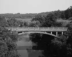 Mederville Bridge |
June 25, 1998 (#98000808) |
County road over the Volga River at Mederville 42°45′50″N 91°25′17″W |
Cox Creek Township | |
| 33 | Monona Township Culvert | June 25, 1998 (#98000806) |
County road over an unnamed stream 43°02′39″N 91°28′35″W |
Monona Township | Replaced in 1998 | |
| 34 | Moser Stone House | September 24, 1984 (#84001236) |
211 S. 1st St. 42°47′04″N 91°05′49″W |
Guttenberg | ||
| 35 | Motor Mill Historic District | 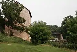 Motor Mill Historic District |
June 9, 2014 (#14000285) |
6 miles (9.7 km) below Elkader[6] 42°48′27″N 91°21′06″W |
Elkader | |
| 36 | Motor Townsite |  Motor Townsite |
August 2, 1977 (#77000502) |
East of Elkader 42°48′28″N 91°21′05″W |
Elkader | |
| 37 | Nieland House | September 24, 1984 (#84001238) |
715 S. 1st St. 42°46′43″N 91°05′45″W |
Guttenberg | ||
| 38 | Parker House |  Parker House |
September 24, 1984 (#84001240) |
1015 S. 2nd St. 42°46′34″N 91°05′51″W |
Guttenberg | |
| 39 | Rialto Price House | 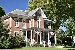 Rialto Price House |
November 21, 1976 (#76000749) |
206 Cedar St., NW. 42°51′16″N 91°24′25″W |
Elkader | |
| 40 | Read Township Culvert | March 12, 1999 (#99000308) |
County road over an unnamed stream 42°50′01″N 91°19′08″W |
Read Township | ||
| 41 | Joseph "Diamond Jo" Reynolds Office Building and House | 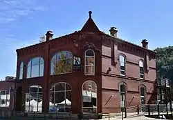 Joseph "Diamond Jo" Reynolds Office Building and House |
February 19, 1982 (#82002614) |
A and Main Sts. 43°01′32″N 91°10′34″W |
McGregor | |
| 42 | Round Barn, Millville Township | 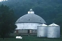 Round Barn, Millville Township |
June 30, 1986 (#86001423) |
U.S. Route 52 42°42′56″N 91°05′04″W |
Millville Township | |
| 43 | St. Joseph Church and Parish Hall | 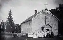 St. Joseph Church and Parish Hall |
November 21, 1976 (#76000750) |
330 1st St., NW. 42°51′05″N 91°24′13″W |
Elkader | |
| 44 | St. Mary's Catholic Church Historic District | 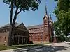 St. Mary's Catholic Church Historic District |
August 12, 2004 (#04000817) |
502, 518, and 520 S. 2nd St. and 214 Herder St. 42°46′52″N 91°05′38″W |
Guttenberg | |
| 45 | St. Olaf Auditorium | 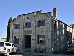 St. Olaf Auditorium |
December 9, 1994 (#94001446) |
118 S. Main St. 42°55′40″N 91°23′10″W |
St. Olaf | |
| 46 | St. Peters United Evangelical Lutheran Church | 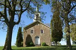 St. Peters United Evangelical Lutheran Church |
December 12, 1976 (#76000743) |
U.S. Route 52 42°49′21″N 91°11′15″W |
Ceres | |
| 47 | Schmidt House | 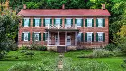 Schmidt House |
March 25, 1977 (#77000503) |
101 Oak St., NW. 42°51′11″N 91°24′26″W |
Elkader | |
| 48 | Peter Stauer House |  Peter Stauer House |
September 13, 2003 (#03000914) |
629 Main St. 43°01′07″N 91°10′55″W |
McGregor | |
| 49 | J.C. Stemmer House | 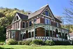 J.C. Stemmer House |
October 21, 1976 (#76000751) |
113 Oak, NW. 42°51′13″N 91°24′29″W |
Elkader | |
| 50 | Stone Barn | September 24, 1984 (#84001244) |
12 Goethe St. 42°46′58″N 91°06′30″W |
Guttenberg | ||
| 51 | Turkey River State Preserve Archeological District | May 30, 1990 (#90000774) |
Estes Point Road 42°43′11″N 91°02′54″W |
Millville | ||
| 52 | Valley Mills |  Valley Mills |
December 12, 1976 (#76000752) |
East of Garnavillo 42°51′50″N 91°11′34″W |
Garnavillo | |
| 53 | Weber House | 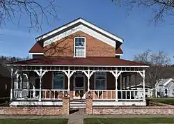 Weber House |
September 24, 1984 (#84001247) |
822 S. River Park Dr. 42°46′37″N 91°05′43″W |
Guttenberg | |
| 54 | Wehmer House | 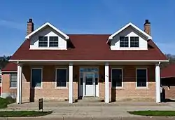 Wehmer House |
September 24, 1984 (#84001249) |
910 S. River Park Dr. 42°46′34″N 91°05′43″W |
Guttenberg |
Former listings
| [3] | Name on the Register | Image | Date listed | Date removed | Location | City or town | Summary |
|---|---|---|---|---|---|---|---|
| 1 | County Road Bridge 15 | June 25, 1998 (#98000804) | December 15, 2003 | County road over an unnamed stream |
Elkader | ||
| 2 | Hartwick House | December 1, 1978 (#78001211) | September 23, 1987 | West of McGregor on U.S. Route 18 |
McGregor |
See also
| Wikimedia Commons has media related to National Register of Historic Places in Clayton County, Iowa. |
References
- The latitude and longitude information provided in this table was derived originally from the National Register Information System, which has been found to be fairly accurate for about 99% of listings. Some locations in this table may have been corrected to current GPS standards.
- "National Register of Historic Places: Weekly List Actions". National Park Service, United States Department of the Interior. Retrieved on February 5, 2021.
- Numbers represent an alphabetical ordering by significant words. Various colorings, defined here, differentiate National Historic Landmarks and historic districts from other NRHP buildings, structures, sites or objects.
- "National Register Information System". National Register of Historic Places. National Park Service. April 24, 2008.
- The eight-digit number below each date is the number assigned to each location in the National Register Information System database, which can be viewed by clicking the number.
- Motor Mill, Elkader Chamber of Commerce, 2011. Accessed 2014-06-20.
| Topics | |
|---|---|
| Lists by state |
|
| Lists by insular areas | |
| Lists by associated state | |
| Other areas | |
| Related | |
| |

Municipalities and communities of Clayton County, Iowa, United States | ||
|---|---|---|
| Cities | Map of Iowa highlighting Clayton County | |
| Townships | ||
| Unincorporated communities | ||
| Footnotes | ‡This populated place also has portions in an adjacent county or counties | |
| ||
This article is issued from Wikipedia. The text is licensed under Creative Commons - Attribution - Sharealike. Additional terms may apply for the media files.