National Register of Historic Places listings in Keokuk County, Iowa
This is a list of the National Register of Historic Places listings in Keokuk County, Iowa.
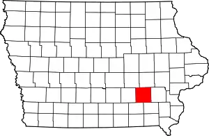
Location of Keokuk County in Iowa
This is intended to be a complete list of the properties and districts on the National Register of Historic Places in Keokuk County, Iowa. Latitude and longitude coordinates are provided for many National Register properties and districts; these locations may be seen together in a map.[1]
There are 10 properties and districts listed on the National Register in the county.
- This National Park Service list is complete through NPS recent listings posted February 5, 2021.[2]
| [3] | Name on the Register[4] | Image | Date listed[5] | Location | City or town | Description |
|---|---|---|---|---|---|---|
| 1 | Bruce Goldfish Fisheries |  Bruce Goldfish Fisheries |
September 20, 1982 (#82002626) |
East of Thornburg off Iowa Highway 22 41°27′16″N 92°18′42″W |
Thornburg | |
| 2 | Keokuk County Courthouse | 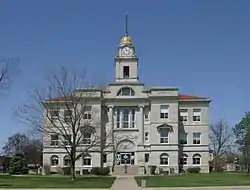 Keokuk County Courthouse |
July 2, 1981 (#81000251) |
Main St. 41°20′00″N 92°12′16″W |
Sigourney | |
| 3 | Lancaster School | 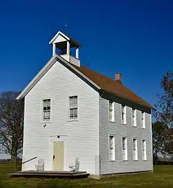 Lancaster School |
October 4, 1984 (#84000010) |
Southeast of Sigourney 41°16′31″N 92°10′02″W |
Sigourney | |
| 4 | Masonic Opera House | 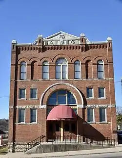 Masonic Opera House |
June 4, 1973 (#73000733) |
201 Barnes St. 41°24′05″N 92°21′17″W |
What Cheer | |
| 5 | Public Square Historic District | 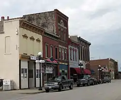 Public Square Historic District |
April 29, 1999 (#99000487) |
Roughly around the Keokuk County Courthouse 41°20′00″N 92°12′16″W |
Sigourney | |
| 6 | Ramsey Building | 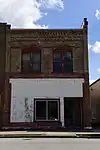 Ramsey Building |
April 24, 2017 (#100000909) |
204 E. Broadway Ave. 41°21′49″N 91°57′12″W |
Keota | |
| 7 | Saints Peter and Paul Roman Catholic Church | Saints Peter and Paul Roman Catholic Church |
August 6, 1986 (#86002277) |
Southeast of Harper 41°18′19″N 92°00′20″W |
Harper | |
| 8 | Sigourney Public Library | 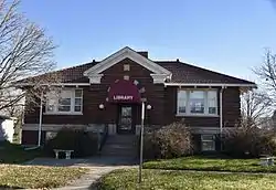 Sigourney Public Library |
May 23, 1983 (#83000381) |
203 N. Jefferson St. 41°20′06″N 92°12′13″W |
Sigourney | |
| 9 | C.F. and Mary Singmaster House |  C.F. and Mary Singmaster House |
January 16, 1998 (#97001608) |
32263 190th St. 41°22′53″N 91°58′49″W |
Keota | |
| 10 | Theodore White House | July 14, 1983 (#83000382) |
Broadway St. 41°26′59″N 92°05′24″W |
South English |
Former listings
| [3] | Name on the Register | Image | Date listed | Date removed | Location | City or town | Summary |
|---|---|---|---|---|---|---|---|
| 1 | Delta Covered Bridge |  Delta Covered Bridge |
November 8, 1974 (#74000795) | November 3, 2003 | S of Delta off IA 108 across North Skunk River |
Delta vicinity | Destroyed by arsonist in 2003 |
| 2 | Hayesville Independent School | August 3, 1990 (#90001195) | October 15, 2014 | 231 Washington St. 41°15′52″N 92°14′59″W |
Hayesville | ||
| 3 | What Cheer City Hall | August 27, 1981 (#81000252) | March 15, 2004 | Barnes and Washington Sts. |
What Cheer |
See also
| Wikimedia Commons has media related to National Register of Historic Places in Keokuk County, Iowa. |
References
- The latitude and longitude information provided in this table was derived originally from the National Register Information System, which has been found to be fairly accurate for about 99% of listings. Some locations in this table may have been corrected to current GPS standards.
- "National Register of Historic Places: Weekly List Actions". National Park Service, United States Department of the Interior. Retrieved on February 5, 2021.
- Numbers represent an alphabetical ordering by significant words. Various colorings, defined here, differentiate National Historic Landmarks and historic districts from other NRHP buildings, structures, sites or objects.
- "National Register Information System". National Register of Historic Places. National Park Service. April 24, 2008.
- The eight-digit number below each date is the number assigned to each location in the National Register Information System database, which can be viewed by clicking the number.
| Topics | |
|---|---|
| Lists by state |
|
| Lists by insular areas | |
| Lists by associated state | |
| Other areas | |
| Related | |
| |

Municipalities and communities of Keokuk County, Iowa, United States | ||
|---|---|---|
| Cities | Map of Iowa highlighting Keokuk County | |
| Unincorporated communities | ||
| Ghost town | ||
| Footnotes | ‡This populated place also has portions in an adjacent county or counties | |
| ||
This article is issued from Wikipedia. The text is licensed under Creative Commons - Attribution - Sharealike. Additional terms may apply for the media files.