National Register of Historic Places listings in Black Hawk County, Iowa
Here is presented a listing of the National Register of Historic Places in Black Hawk County, Iowa.
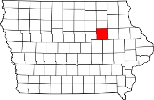
Location of Black Hawk County in Iowa
The list is intended to give a complete review of the properties and districts on the National Register of Historic Places in Black Hawk County, Iowa, United States. Latitude and longitude coordinates are provided for many National Register properties and districts; these locations can be seen on an online map.[1]
There are 50 properties and districts listed in the National Register of the county. Four properties were once listed, but have since been removed.
- This National Park Service list is complete through NPS recent listings posted January 29, 2021.[2]
Current listings
| [3] | Name on the Register[4] | Image | Date listed[5] | Location | City or town | Description |
|---|---|---|---|---|---|---|
| 1 | Bennington No. 4 | 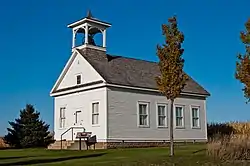 Bennington No. 4 |
January 16, 2001 (#00001651) |
Junction of Bennington and Sage Rds. 42°36′00″N 92°17′50″W |
Waterloo | |
| 2 | Black Hawk County Soldiers Memorial Hall | 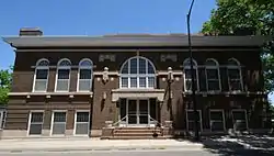 Black Hawk County Soldiers Memorial Hall |
November 29, 1988 (#88001322) |
194 W. 5th St. 42°29′44″N 92°20′18″W |
Waterloo | |
| 3 | Black Hawk Hotel | 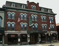 Black Hawk Hotel |
December 19, 2002 (#02001542) |
115-119 Main St. 42°32′15″N 92°26′44″W |
Cedar Falls | |
| 4 | Campbell Baking Company | Campbell Baking Company |
May 2, 2016 (#16000213) |
325 Commercial St. 42°29′49″N 92°20′32″W |
Waterloo | |
| 5 | Cedar Falls Downtown Historic District | 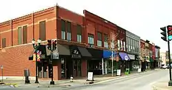 Cedar Falls Downtown Historic District |
October 2, 2017 (#100001673) |
102-422 Main, 100 blk. E. & W. 2nd, 100 blk. E. & W. 3rd, 100 blk. E. 4th Sts. 42°32′10″N 92°26′44″W |
Cedar Falls | |
| 6 | Cedar Falls Ice House | 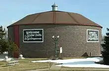 Cedar Falls Ice House |
October 21, 1977 (#77000494) |
Franklin Avenue and First Street 42°32′19″N 92°26′55″W |
Cedar Falls | |
| 7 | Cedar Falls Independent Order of Odd Fellows | 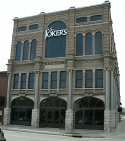 Cedar Falls Independent Order of Odd Fellows |
May 2, 1997 (#97000384) |
401-403 Main St. 42°32′05″N 92°26′41″W |
Cedar Falls | |
| 8 | Cedar Falls Post Office | 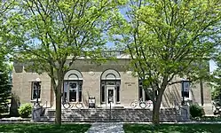 Cedar Falls Post Office |
March 8, 2016 (#16000057) |
217 Washington St. 42°32′10″N 92°26′49″W |
Cedar Falls | |
| 9 | Chapple and Young Block | 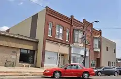 Chapple and Young Block |
September 20, 2002 (#02001025) |
316-318-320 Main St. 42°18′48″N 92°11′21″W |
La Porte City | |
| 10 | Chicago Great Western Railroad-Waterloo Freight Depot | Chicago Great Western Railroad-Waterloo Freight Depot |
January 17, 1997 (#88001325) |
6th St. 42°29′41″N 92°20′01″W |
Waterloo | |
| 11 | Cotton Theater | 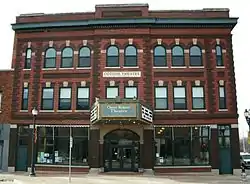 Cotton Theater |
July 23, 1993 (#93000764) |
103 Main St. 42°32′14″N 92°26′42″W |
Cedar Falls | |
| 12 | Dunkerton Bridge | 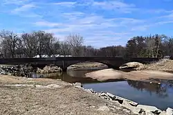 Dunkerton Bridge |
June 25, 1998 (#98000768) |
Local street over Crane Creek 42°34′23″N 92°09′38″W |
Dunkerton | |
| 13 | Dunsmore House | 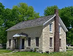 Dunsmore House |
November 17, 1977 (#77000497) |
902 Logan Ave. 42°30′48″N 92°20′14″W |
Waterloo | |
| 14 | Emerson School | 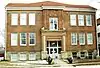 Emerson School |
December 29, 2004 (#04001403) |
314 Randolph St. 42°29′34″N 92°20′51″W |
Waterloo | |
| 15 | Fire Station No. 2 | 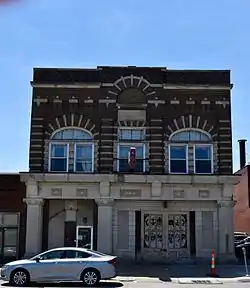 Fire Station No. 2 |
November 29, 1988 (#88001321) |
716 Commercial St. 42°29′38″N 92°20′17″W |
Waterloo | |
| 16 | The Fowler Company Building | 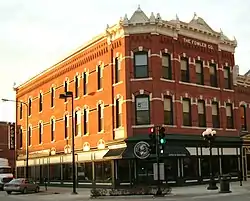 The Fowler Company Building |
September 16, 2009 (#09000712) |
226-228 E. 4th St. 42°29′54″N 92°20′08″W |
Waterloo | |
| 17 | Clement B. Gingrich House | 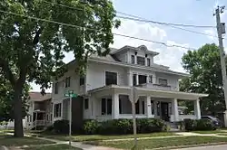 Clement B. Gingrich House |
December 4, 1996 (#96001371) |
300 Walnut St. 42°18′51″N 92°11′18″W |
La Porte City | |
| 18 | Grace Methodist Episcopal Church | 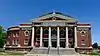 Grace Methodist Episcopal Church |
October 6, 2011 (#11000719) |
633 Walnut St. 42°30′04″N 92°19′51″W |
Waterloo | |
| 19 | Highland Historic District | 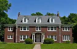 Highland Historic District |
September 24, 1984 (#84001209) |
Roughly bounded by Independence Ave. and Steely, Idaho, and Vine Sts. 42°30′01″N 92°18′42″W |
Waterloo | |
| 20 | Hotel President | .jpg.webp) Hotel President |
April 24, 2017 (#100000484) |
500 Sycamore St. 42°29′56″N 92°20′12″W |
Waterloo | |
| 21 | Hotel Russell-Lamson | 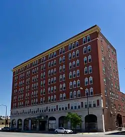 Hotel Russell-Lamson |
November 29, 1988 (#88001324) |
201-215 W. 5th St. 42°29′39″N 92°20′19″W |
Waterloo | |
| 22 | La Porte City Station | 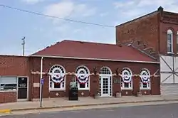 La Porte City Station |
March 13, 1979 (#79003781) |
202 E. Main St. 42°18′55″N 92°11′32″W |
La Porte City | La Porte City's current city hall |
| 23 | August H.J. and Justena Lange Farmstead Historic District | 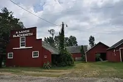 August H.J. and Justena Lange Farmstead Historic District |
May 14, 1997 (#97000385) |
8214 Spring Creek Rd. 42°22′53″N 92°04′29″W |
La Porte City | |
| 24 | LaPorte City Town Hall and Fire Station | 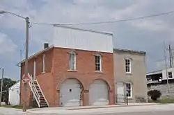 LaPorte City Town Hall and Fire Station |
May 12, 1977 (#77000496) |
413 Chestnut 42°18′49″N 92°11′30″W |
La Porte City | La Porte City's former city hall and fire station |
| 25 | Marsh-Place Building | 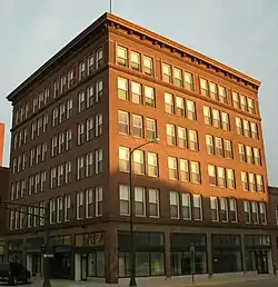 Marsh-Place Building |
October 22, 1998 (#98001272) |
627 Sycamore St. 42°29′51″N 92°20′04″W |
Waterloo | |
| 26 | Master Service Station | 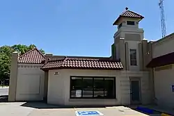 Master Service Station |
February 7, 2011 (#10001204) |
500 Jefferson St. 42°29′42″N 92°20′30″W |
Waterloo | |
| 27 | John N. and Mary McQuilken House | 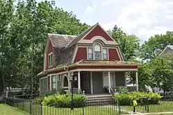 John N. and Mary McQuilken House |
September 8, 1994 (#94001097) |
602 Commercial St. 42°18′46″N 92°11′35″W |
La Porte City | |
| 28 | James Newell Barn | December 12, 1976 (#76000734) |
North of Cedar Falls off U.S. Route 218 42°37′01″N 92°29′38″W |
Cedar Falls | ||
| 29 | Overland Waterloo Company Building |  Overland Waterloo Company Building |
September 22, 2014 (#14000663) |
500 E. 4th St. 42°30′02″N 92°19′58″W |
Waterloo | |
| 30 | Rath Packing Company Administration Building | Rath Packing Company Administration Building |
December 10, 2008 (#08001162) |
1515 E. Sycamore St., 208-212 Elm St. 42°29′33″N 92°19′26″W |
Waterloo | |
| 31 | Roosevelt Elementary School | 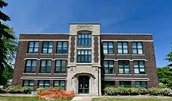 Roosevelt Elementary School |
December 30, 2004 (#04001402) |
200 E. Arlington St. 42°31′06″N 92°20′11″W |
Waterloo | |
| 32 | Round Barn, Washington Township |  Round Barn, Washington Township |
June 30, 1986 (#86001417) |
Off U.S. Route 218 42°35′07″N 92°27′40″W |
Washington Township | |
| 33 | C.A. Rownd Round Barn | 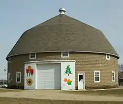 C.A. Rownd Round Barn |
November 19, 1986 (#86003193) |
5102 S. Main 42°29′50″N 92°27′47″W |
Cedar Falls | |
| 34 | Rensselaer Russell House | 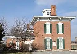 Rensselaer Russell House |
July 5, 1973 (#73000722) |
520 W. 3rd St. 42°29′39″N 92°20′44″W |
Waterloo | |
| 35 | Snowden House | 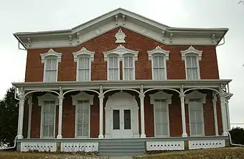 Snowden House |
September 14, 1977 (#77000498) |
306 Washington St. 42°29′39″N 92°20′44″W |
Waterloo | |
| 36 | Syndicate Block | 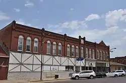 Syndicate Block |
December 21, 2005 (#05001429) |
206, 208, 210, 212, and 216 Main St. 42°18′54″N 92°11′24″W |
La Porte City | |
| 37 | Walnut Street Baptist Church | 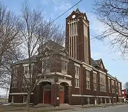 Walnut Street Baptist Church |
August 16, 2000 (#00000983) |
415 Walnut St. 42°30′09″N 92°20′02″W |
Waterloo | |
| 38 | Walnut Street Historic District | September 23, 2019 (#100004414) |
Franklin St., E. 4th St., Argyle St., and E. 2nd St. 42°30′10″N 92°20′04″W |
Waterloo | ||
| 39 | Dr. Jesse Wasson Building | 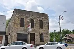 Dr. Jesse Wasson Building |
October 7, 1999 (#99001239) |
201 Main St. 42°18′54″N 92°11′34″W |
La Porte City | |
| 40 | William Waterfield House | 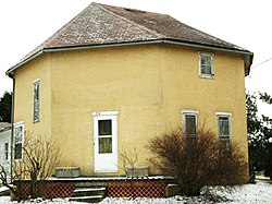 William Waterfield House |
October 19, 1978 (#78001206) |
308 3rd St., S. 42°27′54″N 92°13′11″W |
Raymond | |
| 41 | Waterloo East Commercial Historic District | 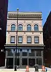 Waterloo East Commercial Historic District |
November 18, 2011 (#11000813) |
128-329 E. 4th, 612-616 Mulberry, 501-632 Sycamore Sts. 42°29′56″N 92°20′06″W |
Waterloo | Iowa's Main Street Commercial Architecture MPS |
| 42 | Waterloo West Commercial Historic District | 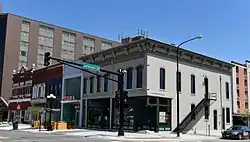 Waterloo West Commercial Historic District |
September 22, 2014 (#14000664) |
217-333 W. 4th., 301-317 W. 5th & 612-716 Jefferson Sts. 42°29′39″N 92°20′26″W |
Waterloo | |
| 43 | Waterloo Masonic Temple | 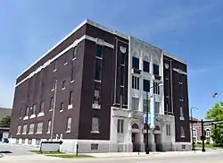 Waterloo Masonic Temple |
December 18, 2013 (#13000921) |
325 E. Park Avenue 42°30′02″N 92°20′09″W |
Waterloo | |
| 44 | Waterloo Public Library (West Branch) |  Waterloo Public Library (West Branch) |
May 23, 1983 (#83000342) |
528 W. 4th St. 42°29′33″N 92°20′35″W |
Waterloo | |
| 45 | Waterloo Public Library-East Side Branch |  Waterloo Public Library-East Side Branch |
November 29, 1988 (#88001323) |
626 Mulberry St. 42°29′56″N 92°19′59″W |
Waterloo | |
| 46 | Henry Weis House | 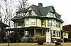 Henry Weis House |
October 30, 1989 (#89001779) |
800 W. 4th St. 42°29′26″N 92°20′45″W |
Waterloo | |
| 47 | Whittier School | 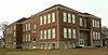 Whittier School |
December 30, 2004 (#04001400) |
1500 3rd St., W. 42°29′14″N 92°21′22″W |
Waterloo | |
| 48 | Wild Historic District | October 23, 2019 (#100004546) |
423, 501 & 509 W. 1st St. 42°32′16″N 92°27′03″W |
Cedar Falls | ||
| 49 | Daniel and Margaret Wild House | 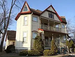 Daniel and Margaret Wild House |
June 19, 2017 (#100001214) |
501 W. 1st St. 42°32′17″N 92°27′04″W |
Cedar Falls | |
| 50 | YMCA Building | YMCA Building |
July 7, 1983 (#83000343) |
154 W. 4th St. 42°29′37″N 92°20′27″W |
Waterloo |
Former listings
| [3] | Name on the Register | Image | Date listed | Date removed | Location | City or town | Summary |
|---|---|---|---|---|---|---|---|
| 1 | Central Hall | January 18, 1984 (#84001204) | May 8, 2002 | University of Northern Iowa campus |
Cedar Falls | ||
| 2 | Crane Creek Bridge | June 25, 1998 (#98000769) | November 3, 2003 | Marquis Rd. over Crane Creek |
Waterloo vicinity | ||
| 3 | Fields Barn | September 19, 1977 (#77000495) | May 12, 2009 | Southwest of Cedar Falls 42°29′00″N 92°29′10″W |
Cedar Falls | ||
| 4 | Forrest Milling Company Oatmeal Mill | June 24, 1980 (#80001430) | September 10, 2008 | North Main Street 42°29′00″N 92°29′10″W |
Cedar Falls | Demolished February 9, 2008.[6] |
See also
| Wikimedia Commons has media related to National Register of Historic Places in Black Hawk County, Iowa. |
References
- The latitude and longitude information provided in this table was derived originally from the National Register Information System, which has been found to be fairly accurate for about 99% of listings. Some locations in this table may have been corrected to current GPS standards.
- "National Register of Historic Places: Weekly List Actions". National Park Service, United States Department of the Interior. Retrieved on January 29, 2021.
- Numbers represent an alphabetical ordering by significant words. Various colorings, defined here, differentiate National Historic Landmarks and historic districts from other NRHP buildings, structures, sites or objects.
- "National Register Information System". National Register of Historic Places. National Park Service. April 24, 2008.
- The eight-digit number below each date is the number assigned to each location in the National Register Information System database, which can be viewed by clicking the number.
- "Olde Broom Factory Restaurant in Cedar Falls Demolished". Iowa Historic Preservation Alliance. February 16, 2008. Retrieved February 8, 2009.
| Topics | |
|---|---|
| Lists by state |
|
| Lists by insular areas | |
| Lists by associated state | |
| Other areas | |
| Related | |
| |

Municipalities and communities of Black Hawk County, Iowa, United States | ||
|---|---|---|
| Cities | Map of Iowa highlighting Black Hawk County | |
| Townships | ||
| CDP | ||
| Other unincorporated communities | ||
| Footnotes | ‡This populated place also has portions in an adjacent county or counties | |
| ||
This article is issued from Wikipedia. The text is licensed under Creative Commons - Attribution - Sharealike. Additional terms may apply for the media files.