National Register of Historic Places listings in Wapello County, Iowa
This is a list of the National Register of Historic Places listings in Wapello County, Iowa.
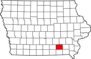
Location of Wapello County in Iowa
This is intended to be a complete list of the properties and districts on the National Register of Historic Places in Wapello County, Iowa, United States. Latitude and longitude coordinates are provided for many National Register properties and districts; these locations may be seen together in a map.[1]
There are 31 properties and districts listed on the National Register in the county.
- This National Park Service list is complete through NPS recent listings posted February 5, 2021.[2]
Current listings
| [3] | Name on the Register[4] | Image | Date listed[5] | Location | City or town | Description |
|---|---|---|---|---|---|---|
| 1 | Administration Building, U.S. Naval Air Station Ottumwa | 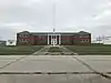 Administration Building, U.S. Naval Air Station Ottumwa |
May 14, 2013 (#13000273) |
Terminal Ave. 41°06′23″N 92°26′27″W |
Ottumwa | |
| 2 | Agassiz School | November 12, 2020 (#100005787) |
608 East Williams St. 40°59′53″N 92°25′00″W |
Ottumwa | ||
| 3 | B'nai Jacob Synagogue | 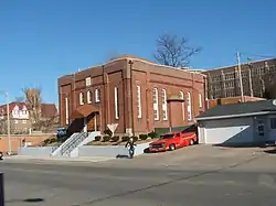 B'nai Jacob Synagogue |
August 10, 2004 (#04000815) |
529 E. Main 41°00′57″N 92°24′25″W |
Ottumwa | |
| 4 | Benson Block | 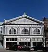 Benson Block |
January 3, 1985 (#85000009) |
109-112 N. Market 41°01′03″N 92°24′35″W |
Ottumwa | |
| 5 | Big 4 Fair Art Hall | 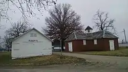 Big 4 Fair Art Hall |
May 18, 1995 (#95000621) |
Water St. at the Wapello County Regional Fairgrounds 40°54′31″N 92°12′53″W |
Eldon | |
| 6 | Burlington Depot | 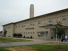 Burlington Depot |
November 26, 2008 (#08001100) |
210 W. Main St. 41°01′09″N 92°24′52″W |
Ottumwa | |
| 7 | Chief Wapello's Memorial Park | 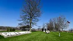 Chief Wapello's Memorial Park |
March 27, 1975 (#75000700) |
Southeast of Agency off U.S. Route 34 40°59′31″N 92°17′32″W |
Agency | |
| 8 | Court Hill Historic District | 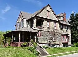 Court Hill Historic District |
January 7, 1998 (#97001605) |
111 E. Court and 407-1004 N. Court Sts. 41°01′31″N 92°24′31″W |
Ottumwa | |
| 9 | Dahlonega School No. 1 | 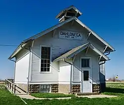 Dahlonega School No. 1 |
August 10, 2000 (#00000934) |
County Road H25, 2 miles (3.2 km) northeast of Ottumwa 41°03′30″N 92°22′13″W |
Ottumwa | |
| 10 | Dibble House | 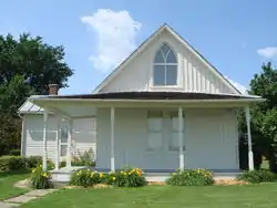 Dibble House |
October 1, 1974 (#74002291) |
Burton and Gothic Sts. 40°55′18″N 92°12′48″W |
Eldon | |
| 11 | Eldon Carnegie Public Library | .jpg.webp) Eldon Carnegie Public Library |
May 30, 1996 (#96000604) |
608 W. Elm St. 40°55′12″N 92°13′32″W |
Eldon | |
| 12 | Fifth Street Bluff Historic District | 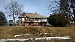 Fifth Street Bluff Historic District |
January 7, 1998 (#97001606) |
Roughly bounded by Jefferson, E. 6th, Washington, and 4th Sts. 41°01′09″N 92°24′26″W |
Ottumwa | |
| 13 | First National Bank | 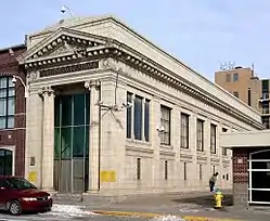 First National Bank |
August 11, 1995 (#95000970) |
131 E. Main St. 41°01′02″N 92°24′42″W |
Ottumwa | |
| 14 | Foster/Bell House | 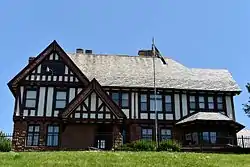 Foster/Bell House |
September 29, 1983 (#83000407) |
205 E. 5th St. 41°01′11″N 92°24′27″W |
Ottumwa | |
| 15 | J.W. Garner Building | 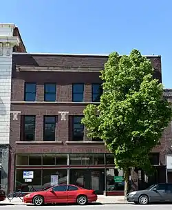 J.W. Garner Building |
February 12, 2010 (#10000003) |
222-224 E. 2nd St. 41°01′03″N 92°24′38″W |
Ottumwa | |
| 16 | Greater Second Street Historic District | %252C_213_East_2nd_Street%252C_Ottumwa%252C_Iowa_LCCN2017706368.tif.jpg.webp) Greater Second Street Historic District |
June 14, 2016 (#16000365) |
201-315 E. 2nd, 116 N. Green, 109 S. Green & 106-112 N. Market 41°01′01″N 92°24′34″W |
Ottumwa | |
| 17 | Historic Railroad District | 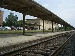 Historic Railroad District |
October 6, 2011 (#11000723) |
Main St. to BNSF Railway tracks between Washington St. & Marion St. 41°01′08″N 92°24′53″W |
Ottumwa | |
| 18 | Hofmann Building | 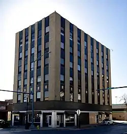 Hofmann Building |
December 27, 2010 (#10001085) |
101 S. Market St. 41°01′04″N 92°24′40″W |
Ottumwa | |
| 19 | Hotel Ottumwa | 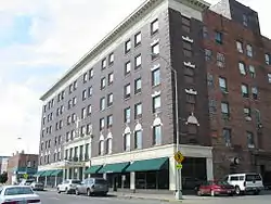 Hotel Ottumwa |
September 25, 2012 (#12000815) |
107 E. 2nd St. 41°01′07″N 92°24′43″W |
Ottumwa | |
| 20 | Jay Funeral Home | 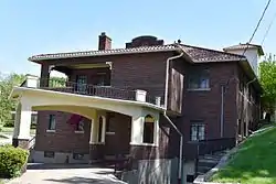 Jay Funeral Home |
August 11, 1995 (#95000971) |
220 North Ct. 41°01′12″N 92°24′35″W |
Ottumwa | |
| 21 | Jefferson Street Viaduct | 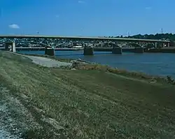 Jefferson Street Viaduct |
May 15, 1998 (#98000475) |
Jefferson St. over the Des Moines River 41°00′39″N 92°24′55″W |
Ottumwa | |
| 22 | Mars Hill | _exterior.jpg.webp) Mars Hill |
September 13, 1974 (#74000814) |
Southeast of Ottumwa 40°53′58″N 92°21′26″W |
Ottumwa | |
| 23 | McHaffey Opera House | .JPG.webp) McHaffey Opera House |
November 22, 1995 (#95001317) |
414 Elm St. 40°55′04″N 92°13′22″W |
Eldon | |
| 24 | North Fellows Historic District |  North Fellows Historic District |
December 27, 2010 (#10001087) |
1200 block of N. Fellows St. and 1204-1212 N. Elm St. 41°01′37″N 92°23′49″W |
Ottumwa | |
| 25 | Ottumwa Cemetery Historic District | 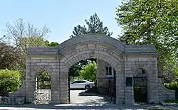 Ottumwa Cemetery Historic District |
August 11, 1995 (#95000968) |
1302 North Ct. 41°01′59″N 92°24′31″W |
Ottumwa | |
| 26 | Ottumwa Public Library | 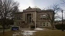 Ottumwa Public Library |
April 27, 1984 (#84001605) |
129 N. Court St. 41°01′11″N 92°25′21″W |
Ottumwa | |
| 27 | Ottumwa Young Women's Christian Association | 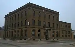 Ottumwa Young Women's Christian Association |
August 24, 2005 (#05000907) |
133 W. 2nd St. 41°01′17″N 92°24′46″W |
Ottumwa | |
| 28 | St. Joseph Hospital Historic District | 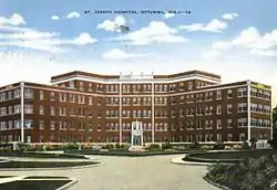 St. Joseph Hospital Historic District |
October 13, 2015 (#15000729) |
312 E. Alta Vista & 317 Vanness Aves. 41°02′14″N 92°23′57″W |
Ottumwa | |
| 29 | U.S. Post Office | 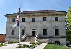 U.S. Post Office |
August 13, 1976 (#76000810) |
Court and 4th Sts. 41°01′07″N 92°24′38″W |
Ottumwa | |
| 30 | Vogel Place Historic District | 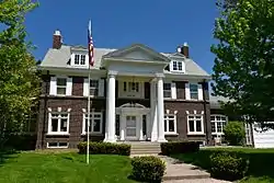 Vogel Place Historic District |
August 11, 1995 (#95000967) |
Roughly bounded by the Ottumwa Country Club, Court St., the Ottumwa Cemetery, and the former St. Joseph Hospital 41°02′15″N 92°24′10″W |
Ottumwa | |
| 31 | Wapello County Courthouse | 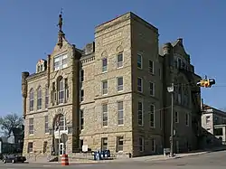 Wapello County Courthouse |
July 2, 1981 (#81000272) |
Court St. 41°01′11″N 92°24′38″W |
Ottumwa |
Former listings
| [3] | Name on the Register | Image | Date listed | Date removed | Location | Summary |
|---|---|---|---|---|---|---|
| 1 | Benson Building | 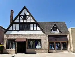 Benson Building |
August 11, 1995 (#95000969) | March 7, 2019 | 214 E. 2nd St. 41°01′01″N 92°24′37″W |
The building was destroyed in a fire in 2018. |
See also
| Wikimedia Commons has media related to National Register of Historic Places in Wapello County, Iowa. |
References
- The latitude and longitude information provided in this table was derived originally from the National Register Information System, which has been found to be fairly accurate for about 99% of listings. Some locations in this table may have been corrected to current GPS standards.
- "National Register of Historic Places: Weekly List Actions". National Park Service, United States Department of the Interior. Retrieved on February 5, 2021.
- Numbers represent an alphabetical ordering by significant words. Various colorings, defined here, differentiate National Historic Landmarks and historic districts from other NRHP buildings, structures, sites or objects.
- "National Register Information System". National Register of Historic Places. National Park Service. April 24, 2008.
- The eight-digit number below each date is the number assigned to each location in the National Register Information System database, which can be viewed by clicking the number.
| Topics | |
|---|---|
| Lists by state |
|
| Lists by insular areas | |
| Lists by associated state | |
| Other areas | |
| Related | |
| |

Municipalities and communities of Wapello County, Iowa, United States | ||
|---|---|---|
| Cities | Map of Iowa highlighting Wapello County | |
| Townships | ||
| Unincorporated communities | ||
| Footnotes | ‡This populated place also has portions in an adjacent county or counties | |
| ||
This article is issued from Wikipedia. The text is licensed under Creative Commons - Attribution - Sharealike. Additional terms may apply for the media files.