National Register of Historic Places listings in Fayette County, Iowa
This is a list of the National Register of Historic Places listings in Fayette County, Iowa.
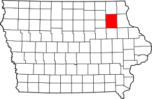
Location of Fayette County in Iowa
This is intended to be a complete list of the properties and districts on the National Register of Historic Places in Fayette County, Iowa, United States. Latitude and longitude coordinates are provided for many National Register properties and districts; these locations may be seen together in a map.[1]
There are 29 properties listed on the National Register in the county.
- This National Park Service list is complete through NPS recent listings posted January 29, 2021.[2]
| [3] | Name on the Register[4] | Image | Date listed[5] | Location | City or town | Description |
|---|---|---|---|---|---|---|
| 1 | Abraham Lincoln Statue and Park |  Abraham Lincoln Statue and Park |
October 30, 2000 (#00001197) |
Junction of Mill and Stone 43°00′13″N 91°39′53″W |
Clermont | |
| 2 | Bigler Building | 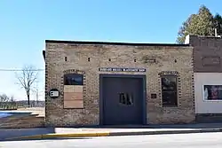 Bigler Building |
June 9, 1995 (#95000691) |
210 Mill St. 43°00′01″N 91°39′22″W |
Clermont | |
| 3 | Chicago, Milwaukee, St. Paul and Pacific Railroad Company Depot | December 28, 1978 (#78001219) |
Northeast of Fayette off Iowa Highway 150 42°52′16″N 91°46′59″W |
Fayette | ||
| 4 | Church of the Saviour Episcopal Church and David Henderson Statue |  Church of the Saviour Episcopal Church and David Henderson Statue |
October 30, 2000 (#00001196) |
Junction of Mill and Thompson 43°00′10″N 91°39′14″W |
Clermont | |
| 5 | Clermont Public School | 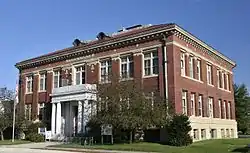 Clermont Public School |
November 22, 1995 (#95001316) |
505 Larrabee St. 42°59′48″N 91°39′11″W |
Clermont | |
| 6 | College Hall | 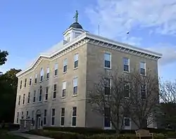 College Hall |
November 7, 1976 (#76000770) |
200 block of E. Clark 42°50′30″N 91°48′07″W |
Fayette | |
| 7 | Eldorado Bridge | 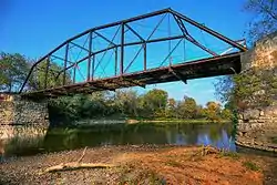 Eldorado Bridge |
June 25, 1998 (#98000783) |
State St. over the Turkey River 43°03′13″N 91°50′05″W |
Eldorado | |
| 8 | The Elgin Block | May 8, 2008 (#08000374) |
225-231 Center St. 42°57′26″N 91°37′37″W |
Elgin | ||
| 9 | Fayette County Courthouse | 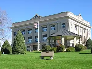 Fayette County Courthouse |
July 2, 1981 (#81000236) |
Pine St. 42°57′38″N 91°48′21″W |
West Union | |
| 10 | First Baptist Church of West Union | 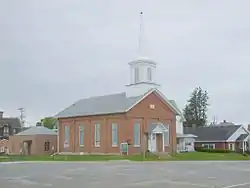 First Baptist Church of West Union |
October 7, 1999 (#99001240) |
Main and Vine Sts. 42°57′46″N 91°48′31″W |
West Union | |
| 11 | Grimes Octagon Barn | 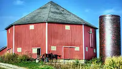 Grimes Octagon Barn |
June 30, 1986 (#86001428) |
Off Iowa Highway 56 42°56′10″N 91°45′01″W |
West Union | |
| 12 | Alfred Hanson House | 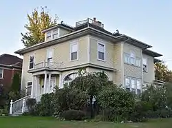 Alfred Hanson House |
July 12, 1984 (#84001252) |
403 N. Frederick Ave. 42°41′01″N 91°54′46″W |
Oelwein | |
| 13 | Hardware Building | July 15, 1977 (#77000516) |
223 Mill St. 42°50′23″N 91°39′25″W |
Wadena | ||
| 14 | Hobson Block | 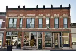 Hobson Block |
November 7, 2008 (#08001042) |
110-114 S. Vine St. 42°57′40″N 91°48′29″W |
West Union | |
| 15 | Hotel Mealey | 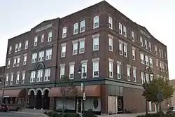 Hotel Mealey |
January 27, 1983 (#83000357) |
102 S. Frederick Ave. 42°40′37″N 91°54′49″W |
Oelwein | |
| 16 | Maple View Sanitarium | 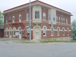 Maple View Sanitarium |
July 21, 1998 (#98000866) |
100 N. Walnut St. 42°57′41″N 91°48′22″W |
West Union | |
| 17 | Maynard Town Hall and Jail | October 30, 1997 (#97001286) |
330 Main St., W. 42°46′42″N 91°53′11″W |
Maynard | ||
| 18 | Mill Race Bridge | 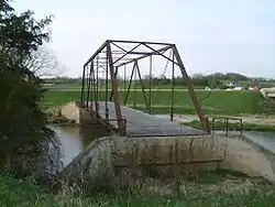 Mill Race Bridge |
June 25, 1998 (#98000784) |
Pheasant Rd. over the Turkey River 43°04′39″N 91°53′21″W |
Eldorado | |
| 19 | Montauk | 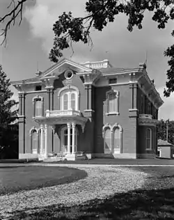 Montauk |
February 21, 1973 (#73000725) |
1 mile northeast of Clermont on U.S. Route 18 43°00′49″N 91°38′25″W |
Clermont | Home of William Larrabee, 12th Governor of Iowa, built in 1874. Property includes a caretaker's house, barn, machine shed, work shop, ice house-creamery and laundry buildings. |
| 20 | August Nus Polygonal Barn | June 30, 1986 (#86001427) |
County Road C2, W. 42°45′35″N 91°38′23″W |
Arlington | 1906 flat roofed clay tile polygon shaped barn, one of 4 known to have been built in Iowa. | |
| 21 | Otter Creek Bridge | June 25, 1998 (#98000781) |
40th St. over Otter Creek 42°41′10″N 91°56′49″W |
Oelwein | 1917 concrete bridge constructed by day laborers. | |
| 22 | St. Luke's School and Recreation Center | August 24, 2005 (#05000899) |
212 East Main 43°04′01″N 91°55′49″W |
St. Lucas | ||
| 23 | Stoe Creek Bridge | June 25, 1998 (#98000782) |
V Ave. over Stoe Creek 42°47′30″N 92°00′08″W |
Oelwein | Replaced in 2007 | |
| 24 | Sumner Bridge | June 25, 1998 (#98000785) |
160th St. over the Little Wapsipinicon River 43°04′39″N 91°53′21″W |
Sumner | ||
| 25 | Twin Bridge |  Twin Bridge |
June 25, 1998 (#98000779) |
130th St. over the Little Volga River 42°50′04″N 91°51′53″W |
Fayette | |
| 26 | Union Sunday School | .jpg.webp) Union Sunday School |
November 5, 1974 (#74000785) |
McGregor and Larrabee Sts. 43°00′10″N 91°39′25″W |
Clermont | |
| 27 | Vine Street Bridge | 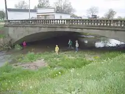 Vine Street Bridge |
June 25, 1998 (#98000780) |
South Vine St. over Otter Creek 42°57′16″N 91°48′29″W |
West Union | |
| 28 | West Auburn Bridge | 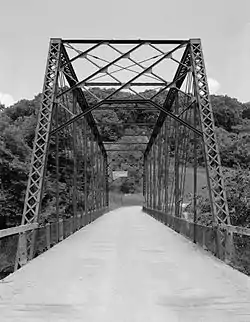 West Auburn Bridge |
June 25, 1998 (#98000786) |
Near Neon Rd. over the Turkey River 43°00′59″N 91°52′43″W |
West Union | |
| 29 | West Union Commercial Historic District | 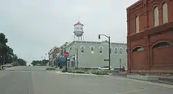 West Union Commercial Historic District |
May 4, 2015 (#15000191) |
Roughly bounded by N. and S. Vine, Main, Walnut, and Plum Streets 42°57′41″N 91°48′26″W |
West Union |
See also
| Wikimedia Commons has media related to National Register of Historic Places in Fayette County, Iowa. |
References
- The latitude and longitude information provided in this table was derived originally from the National Register Information System, which has been found to be fairly accurate for about 99% of listings. Some locations in this table may have been corrected to current GPS standards.
- "National Register of Historic Places: Weekly List Actions". National Park Service, United States Department of the Interior. Retrieved on January 29, 2021.
- Numbers represent an alphabetical ordering by significant words. Various colorings, defined here, differentiate National Historic Landmarks and historic districts from other NRHP buildings, structures, sites or objects.
- "National Register Information System". National Register of Historic Places. National Park Service. April 24, 2008.
- The eight-digit number below each date is the number assigned to each location in the National Register Information System database, which can be viewed by clicking the number.
| Topics | |
|---|---|
| Lists by state |
|
| Lists by insular areas | |
| Lists by associated state | |
| Other areas | |
| Related | |
| |

Municipalities and communities of Fayette County, Iowa, United States | ||
|---|---|---|
| Cities | Map of Iowa highlighting Fayette County | |
| Townships | ||
| Unincorporated communities | ||
| Footnotes | ‡This populated place also has portions in an adjacent county or counties | |
| ||
This article is issued from Wikipedia. The text is licensed under Creative Commons - Attribution - Sharealike. Additional terms may apply for the media files.