National Register of Historic Places listings in Franklin County, Iowa
This is a list of the National Register of Historic Places listings in Franklin County, Iowa.
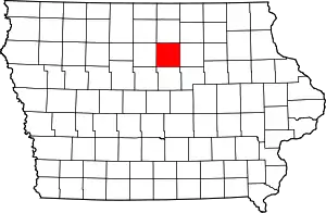
Location of Franklin County in Iowa
This is intended to be a complete list of the properties and districts on the National Register of Historic Places in Franklin County, Iowa, United States. Latitude and longitude coordinates are provided for many National Register properties and districts; these locations may be seen together in a map.[1]
There are 12 properties and districts listed on the National Register in the county.
- This National Park Service list is complete through NPS recent listings posted February 5, 2021.[2]
| [3] | Name on the Register[4] | Image | Date listed[5] | Location | City or town | Description |
|---|---|---|---|---|---|---|
| 1 | Beeds Lake State Park, Civilian Conservation Corps Area | 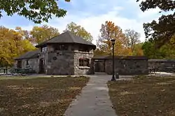 Beeds Lake State Park, Civilian Conservation Corps Area |
November 15, 1990 (#90001672) |
Junction of Iowa Highways 3 and 134 42°46′15″N 93°14′21″W |
Hampton | |
| 2 | H.E. Boehmler House | 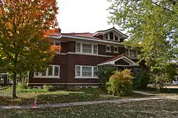 H.E. Boehmler House |
December 13, 1991 (#91001829) |
105 2nd St., SE. 42°44′26″N 93°12′18″W |
Hampton | |
| 3 | Franklin County Courthouse | 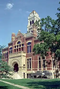 Franklin County Courthouse |
August 13, 1976 (#76000772) |
Central Ave. and 1st St., NW. 42°44′29″N 93°12′32″W |
Hampton | |
| 4 | Franklin County G. A. R. Soldiers' Memorial Hall | 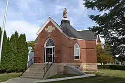 Franklin County G. A. R. Soldiers' Memorial Hall |
December 13, 1991 (#91001828) |
3 Federal St., N. 42°44′29″N 93°12′25″W |
Hampton | |
| 5 | Franklin County Sheriff's Residence and Jail | 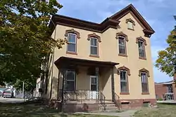 Franklin County Sheriff's Residence and Jail |
August 16, 1996 (#96000896) |
18 E. Central Ave. 42°44′31″N 93°12′23″W |
Hampton | |
| 6 | Hampton Double Square Historic District | 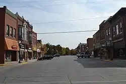 Hampton Double Square Historic District |
August 28, 2003 (#03000834) |
Roughly bounded by 2nd Ave., 1st Ave., the alley west of 1st St., and the alley east of Federal 42°44′31″N 93°12′28″W |
Hampton | |
| 7 | Dr. O.B. Harriman House | 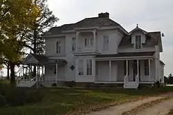 Dr. O.B. Harriman House |
February 5, 1987 (#87000011) |
26 10th St., NW. 42°44′31″N 93°13′14″W |
Hampton | |
| 8 | Maysville Schoolhouse | 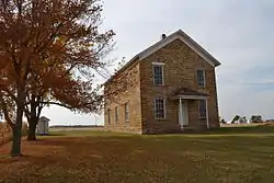 Maysville Schoolhouse |
June 17, 1981 (#81000237) |
South of Hampton 42°40′00″N 93°12′11″W |
Hampton | |
| 9 | Reeve Electric Association Plant | 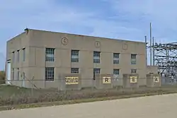 Reeve Electric Association Plant |
April 6, 1990 (#89002307) |
Rural Route 1 southwest of Hampton 42°41′14″N 93°13′58″W |
Hampton | |
| 10 | Leander Reeve House | 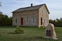 Leander Reeve House |
July 17, 1979 (#79000896) |
Southeast of Hampton on Iowa Highway 134 42°40′36″N 93°09′49″W |
Hampton | |
| 11 | St. John's Danish Evangelical Lutheran Church Historic District | 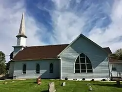 St. John's Danish Evangelical Lutheran Church Historic District |
October 13, 2015 (#15000726) |
1207 Indigo Ave. 42°43′10″N 93°20′24″W |
Hampton | |
| 12 | Herman Wood Round Barn | 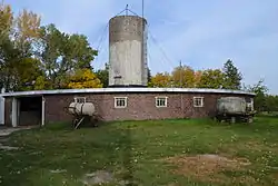 Herman Wood Round Barn |
June 30, 1986 (#86001431) |
U.S. Route 65 42°33′28″N 93°15′02″W |
Iowa Falls |
See also
| Wikimedia Commons has media related to National Register of Historic Places in Franklin County, Iowa. |
References
- The latitude and longitude information provided in this table was derived originally from the National Register Information System, which has been found to be fairly accurate for about 99% of listings. Some locations in this table may have been corrected to current GPS standards.
- "National Register of Historic Places: Weekly List Actions". National Park Service, United States Department of the Interior. Retrieved on February 5, 2021.
- Numbers represent an alphabetical ordering by significant words. Various colorings, defined here, differentiate National Historic Landmarks and historic districts from other NRHP buildings, structures, sites or objects.
- "National Register Information System". National Register of Historic Places. National Park Service. April 24, 2008.
- The eight-digit number below each date is the number assigned to each location in the National Register Information System database, which can be viewed by clicking the number.
| Topics | |
|---|---|
| Lists by state |
|
| Lists by insular areas | |
| Lists by associated state | |
| Other areas | |
| Related | |
| |

Municipalities and communities of Franklin County, Iowa, United States | ||
|---|---|---|
| Cities | Map of Iowa highlighting Franklin County | |
| Townships | ||
| CDPs | ||
| Unincorporated communities | ||
| Footnotes | ‡This populated place also has portions in an adjacent county or counties | |
| ||
This article is issued from Wikipedia. The text is licensed under Creative Commons - Attribution - Sharealike. Additional terms may apply for the media files.