National Register of Historic Places listings in Warren County, Iowa
This is a list of the National Register of Historic Places listings in Warren County, Iowa.
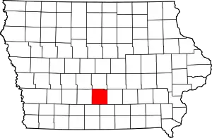
Location of Warren County in Iowa
This is intended to be a complete list of the properties and districts on the National Register of Historic Places in Warren County, Iowa, United States. Latitude and longitude coordinates are provided for many National Register properties and districts; these locations may be seen together in a map.[1]
There are 13 properties and districts listed on the National Register in the county.
- This National Park Service list is complete through NPS recent listings posted February 5, 2021.[2]
Current listings
| [3] | Name on the Register[4] | Image | Date listed[5] | Location | City or town | Description |
|---|---|---|---|---|---|---|
| 1 | Coal Creek Bridge | 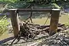 Coal Creek Bridge |
May 15, 1998 (#98000473) |
2404 Fillmore St. over Coal Creek 41°25′44″N 93°20′46″W |
Carlisle | |
| 2 | Hoosier Row School | 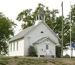 Hoosier Row School |
June 23, 2011 (#11000393) |
15246 County Road R63 41°18′15″N 93°37′02″W |
Indianola vicinity | |
| 3 | Indianola Carnegie Library | 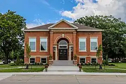 Indianola Carnegie Library |
September 5, 2017 (#100001568) |
106 W. Boston Ave. 41°21′45″N 93°33′43″W |
Indianola | |
| 4 | Indianola High School | 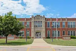 Indianola High School |
October 24, 2002 (#02001247) |
301 N. Buxton 41°21′46″N 93°33′45″W |
Indianola | |
| 5 | Lake Ahquabi State Park, Picnic Area (Area A) | .jpg.webp) Lake Ahquabi State Park, Picnic Area (Area A) |
November 15, 1990 (#90001663) |
1650 118th Ave. 41°17′23″N 93°35′01″W |
Indianola | |
| 6 | Lake Ahquabi State Park, Bathhouse Area (Area B) | .jpg.webp) Lake Ahquabi State Park, Bathhouse Area (Area B) |
November 15, 1990 (#90001664) |
1650 118th Ave. 41°17′25″N 93°35′25″W |
Indianola | |
| 7 | Lake Ahquabi State Park, Refectory Area (Area C) | .jpg.webp) Lake Ahquabi State Park, Refectory Area (Area C) |
November 15, 1990 (#90001665) |
1650 118th Ave. 41°17′19″N 93°35′25″W |
Indianola | |
| 8 | Octagon Barn, Otter Township | 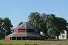 Octagon Barn, Otter Township |
June 30, 1986 (#86001448) |
Off Iowa Highway 205 41°16′07″N 93°26′35″W |
Otter Township | |
| 9 | Palmyra Methodist Episcopal Church | 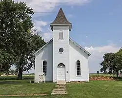 Palmyra Methodist Episcopal Church |
October 1, 1979 (#79000945) |
Southwest of Hartford 41°26′04″N 93°26′05″W |
Palmyra | |
| 10 | Polled Hereford Breed Origin Site | 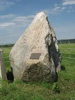 Polled Hereford Breed Origin Site |
June 24, 1983 (#83000408) |
Southwest of Indianola 41°15′32″N 93°40′54″W |
Indianola | |
| 11 | Science Hall | 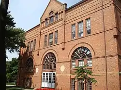 Science Hall |
May 8, 1991 (#91000535) |
Simpson College campus 41°21′54″N 93°34′25″W |
Indianola | |
| 12 | United Presbyterian Church, Summerset | 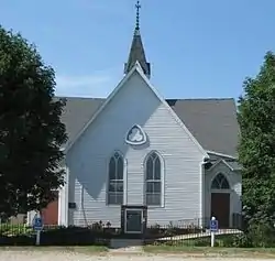 United Presbyterian Church, Summerset |
November 7, 1976 (#76000811) |
U.S. Route 65 41°28′16″N 93°33′38″W |
Scotch Ridge |
Former listing
| [3] | Name on the Register | Image | Date listed | Date removed | Location | City or town | Summary |
|---|---|---|---|---|---|---|---|
| 1 | Warren County Court House | 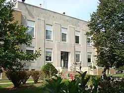 Warren County Court House |
August 28, 2003 (#03000818) | September 19, 2019 | 115 N. Howard Ave. 41°21′40″N 93°33′41″E |
Indianola | It was a part of the PWA-Era County Courthouses of IA MPS. Because of mold and other issues the building was demolished in 2019.[6] |
See also
| Wikimedia Commons has media related to National Register of Historic Places in Warren County, Iowa. |
References
- The latitude and longitude information provided in this table was derived originally from the National Register Information System, which has been found to be fairly accurate for about 99% of listings. Some locations in this table may have been corrected to current GPS standards.
- "National Register of Historic Places: Weekly List Actions". National Park Service, United States Department of the Interior. Retrieved on February 5, 2021.
- Numbers represent an alphabetical ordering by significant words. Various colorings, defined here, differentiate National Historic Landmarks and historic districts from other NRHP buildings, structures, sites or objects.
- "National Register Information System". National Register of Historic Places. National Park Service. April 24, 2008.
- The eight-digit number below each date is the number assigned to each location in the National Register Information System database, which can be viewed by clicking the number.
- Laura Terrell (May 31, 2019). "Down it goes! Crumbling Warren County Courthouse demolished". Des Moines: KCCI. Retrieved 2019-08-13.
| Topics | |
|---|---|
| Lists by state |
|
| Lists by insular areas | |
| Lists by associated state | |
| Other areas | |
| Related | |
| |

Municipalities and communities of Warren County, Iowa, United States | ||
|---|---|---|
| Cities | Map of Iowa highlighting Warren County | |
| Townships |
| |
| Unincorporated communities | ||
| Footnotes | ‡This populated place also has portions in an adjacent county or counties | |
| ||
This article is issued from Wikipedia. The text is licensed under Creative Commons - Attribution - Sharealike. Additional terms may apply for the media files.