National Register of Historic Places listings in Monroe County, Iowa
This is a list of the National Register of Historic Places listings in Monroe County, Iowa.
Location of Monroe County in Iowa
This is intended to be a complete list of the properties and districts on the National Register of Historic Places in Monroe County, Iowa, United States. Latitude and longitude coordinates are provided for many National Register properties and districts; these locations may be seen together in a map.[1]
There are 11 properties and districts listed on the National Register in the county.
- This National Park Service list is complete through NPS recent listings posted January 29, 2021.[2]
| [3] | Name on the Register[4] | Image | Date listed[5] | Location | City or town | Description |
|---|---|---|---|---|---|---|
| 1 | Albia Square and Central Commercial Historic District | 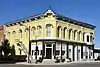 Albia Square and Central Commercial Historic District |
January 3, 1985 (#85000007) |
Roughly bounded by the alley of S. and N. Clinton, E. and W. A Ave., N. and S. 2nd St., and E. and W. 2nd Ave. 41°01′36″N 92°48′26″W |
Albia | |
| 2 | Brick Gothic House | April 14, 1994 (#94000351) |
1.25 miles south of Albia, 0.75 miles east of Iowa Highway 5, and 0.5 miles west of County Road T35 40°59′30″N 92°48′13″W |
Albia | ||
| 3 | Buxton Historic Townsite | August 9, 1983 (#83000392) |
Address Restricted |
Lovilia | ||
| 4 | Clark Round Barn | June 30, 1986 (#86001465) |
County Road T7H 40°58′46″N 92°52′50″W |
Tyrone | ||
| 5 | Elbert-Bates House | 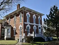 Elbert-Bates House |
June 27, 1985 (#85001379) |
106 2nd Ave., W. 41°01′30″N 92°48′34″W |
Albia | |
| 6 | Dr. George A. Jenkins House | 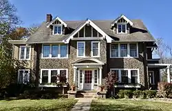 Dr. George A. Jenkins House |
February 5, 1987 (#87000027) |
223 S. C St. 41°01′27″N 92°48′43″W |
Albia | |
| 7 | Monroe County Courthouse | 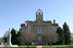 Monroe County Courthouse |
July 2, 1981 (#81000258) |
Main St. 41°01′45″N 92°48′26″W |
Albia | |
| 8 | Noble-Kendall House | 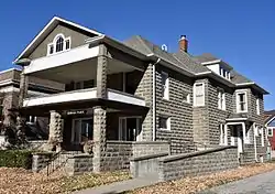 Noble-Kendall House |
April 12, 1984 (#84001289) |
209 E. Benton Ave. 41°01′38″N 92°48′18″W |
Albia | |
| 9 | T.B. Perry House | 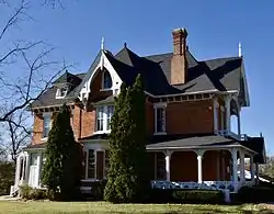 T.B. Perry House |
July 14, 1983 (#83000393) |
212 Benton Ave., W. 41°01′35″N 92°48′22″W |
Albia | |
| 10 | Saint Patrick's Roman Catholic Church | May 6, 1992 (#92000426) |
U.S. Route 34 west of Albia 41°00′48″N 92°57′20″W |
Albia | ||
| 11 | Arvine and Elizabeth W. White House | 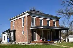 Arvine and Elizabeth W. White House |
September 8, 1994 (#94001100) |
309 N. Main St. 41°01′50″N 92°48′26″W |
Albia |
See also
| Wikimedia Commons has media related to National Register of Historic Places in Monroe County, Iowa. |
References
- The latitude and longitude information provided in this table was derived originally from the National Register Information System, which has been found to be fairly accurate for about 99% of listings. Some locations in this table may have been corrected to current GPS standards.
- "National Register of Historic Places: Weekly List Actions". National Park Service, United States Department of the Interior. Retrieved on January 29, 2021.
- Numbers represent an alphabetical ordering by significant words. Various colorings, defined here, differentiate National Historic Landmarks and historic districts from other NRHP buildings, structures, sites or objects.
- "National Register Information System". National Register of Historic Places. National Park Service. April 24, 2008.
- The eight-digit number below each date is the number assigned to each location in the National Register Information System database, which can be viewed by clicking the number.
| Topics | |
|---|---|
| Lists by state |
|
| Lists by insular areas | |
| Lists by associated state | |
| Other areas | |
| Related | |
| |

Municipalities and communities of Monroe County, Iowa, United States | ||
|---|---|---|
| Cities | Map of Iowa highlighting Monroe County | |
| Unincorporated communities | ||
| Ghost town | ||
| Footnotes | ‡This populated place also has portions in an adjacent county or counties | |
| ||
This article is issued from Wikipedia. The text is licensed under Creative Commons - Attribution - Sharealike. Additional terms may apply for the media files.