National Register of Historic Places listings in Mitchell County, Iowa
This is a list of the National Register of Historic Places listings in Mitchell County, Iowa.
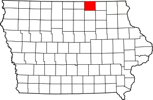
Location of Mitchell County in Iowa
This is intended to be a complete list of the properties and districts on the National Register of Historic Places in Mitchell County, Iowa, United States. Latitude and longitude coordinates are provided for many National Register properties and districts; these locations may be seen together in a map.[1]
There are 10 properties and districts listed on the National Register in the county.
- This National Park Service list is complete through NPS recent listings posted February 5, 2021.[2]
| [3] | Name on the Register[4] | Image | Date listed[5] | Location | City or town | Description |
|---|---|---|---|---|---|---|
| 1 | Cedar Valley Seminary | 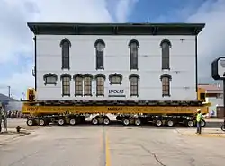 Cedar Valley Seminary |
November 17, 1977 (#77000541) |
200 N. 7th St. 43°17′10″N 92°48′49″W |
Osage | |
| 2 | Nathaniel Cobb and Lucetia Baily Deering House | 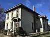 Nathaniel Cobb and Lucetia Baily Deering House |
January 26, 2001 (#00001678) |
903 State St. 43°17′04″N 92°48′49″W |
Osage | |
| 3 | First Lutheran Church | 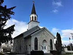 First Lutheran Church |
December 12, 1976 (#76000795) |
212 N. Main St. 43°22′48″N 92°55′32″W |
St. Ansgar | |
| 4 | Mitchell County Courthouse |  Mitchell County Courthouse |
August 29, 1977 (#77000542) |
500 State St. 43°16′57″N 92°48′50″W |
Osage | |
| 5 | Mitchell Powerhouse and Dam | 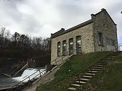 Mitchell Powerhouse and Dam |
December 8, 1978 (#78001246) |
Red Cedar River 43°19′06″N 92°52′51″W |
Mitchell | |
| 6 | Osage Commercial Historic District |  Osage Commercial Historic District |
September 12, 2002 (#02001030) |
700, 600, and parts of the 500 blocks of Main St. 43°17′02″N 92°48′40″W |
Osage | |
| 7 | Saint Ansgar Public School | February 6, 2020 (#100004976) |
202 South Washington St. 43°22′38″N 92°55′24″W |
St. Ansgar | ||
| 8 | Nels Severson Barn | July 15, 1977 (#77000540) |
North of Carpenter 43°25′21″N 93°00′40″W |
Carpenter | ||
| 9 | Union Presbyterian Church | 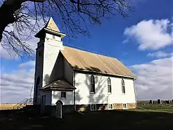 Union Presbyterian Church |
April 13, 1977 (#77000543) |
Northwest of Stacyville 43°28′47″N 92°48′35″W |
Stacyville | |
| 10 | Walnut Grove School | 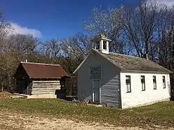 Walnut Grove School |
September 12, 2002 (#02001028) |
3272 Foothill Ave. 43°14′16″N 92°55′10″W |
Osage |
Former listing
| [3] | Name on the Register | Image | Date listed | Date removed | Location | City or town | Summary |
|---|---|---|---|---|---|---|---|
| 1 | Otranto Bridge | 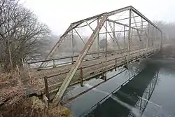 Otranto Bridge |
May 15, 1998 (#98000495) | October 20, 2020 | 480th Ave. over the Big Cedar River 43°27′29″N 92°58′55″W |
St. Ansgar | Dismantled |
See also
| Wikimedia Commons has media related to National Register of Historic Places in Mitchell County, Iowa. |
References
- The latitude and longitude information provided in this table was derived originally from the National Register Information System, which has been found to be fairly accurate for about 99% of listings. Some locations in this table may have been corrected to current GPS standards.
- "National Register of Historic Places: Weekly List Actions". National Park Service, United States Department of the Interior. Retrieved on February 5, 2021.
- Numbers represent an alphabetical ordering by significant words. Various colorings, defined here, differentiate National Historic Landmarks and historic districts from other NRHP buildings, structures, sites or objects.
- "National Register Information System". National Register of Historic Places. National Park Service. April 24, 2008.
- The eight-digit number below each date is the number assigned to each location in the National Register Information System database, which can be viewed by clicking the number.
| Topics | |
|---|---|
| Lists by state |
|
| Lists by insular areas | |
| Lists by associated state | |
| Other areas | |
| Related | |
| |

Municipalities and communities of Mitchell County, Iowa, United States | ||
|---|---|---|
| Cities | Map of Iowa highlighting Mitchell County | |
| Townships | ||
| CDPs | ||
| Footnotes | ‡This populated place also has portions in an adjacent county or counties | |
| ||
This article is issued from Wikipedia. The text is licensed under Creative Commons - Attribution - Sharealike. Additional terms may apply for the media files.