National Register of Historic Places listings in Shelby County, Iowa
This is a list of the National Register of Historic Places listings in Shelby County, Iowa.
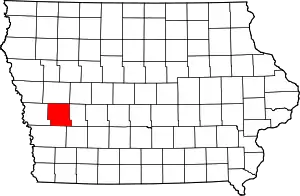
Location of Shelby County in Iowa
This is intended to be a complete list of the properties and districts on the National Register of Historic Places in Shelby County, Iowa, United States. Latitude and longitude coordinates are provided for many National Register properties and districts; these locations may be seen together in a map.[1]
There are 13 properties and districts listed on the National Register in the county.
- This National Park Service list is complete through NPS recent listings posted February 5, 2021.[2]
| [3] | Name on the Register[4] | Image | Date listed[5] | Location | City or town | Description |
|---|---|---|---|---|---|---|
| 1 | Chicago, Rock Island and Pacific Railroad Stone Arch Viaduct | July 15, 1998 (#98000870) |
0.5 miles northwest of the junction of St. F66 and Hackberry Rd. 41°31′26″N 95°26′11″W |
Shelby | ||
| 2 | Jens Otto Christiansen House | January 16, 1997 (#96001584) |
2105 College Ave. 41°35′38″N 95°03′37″W |
Elk Horn | ||
| 3 | Floral Hall | 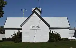 Floral Hall |
April 11, 1985 (#85000765) |
314 4th St. on Shelby County Fairgrounds 41°39′53″N 95°18′48″W |
Harlan | |
| 4 | Harlan Courthouse Square Commercial District | 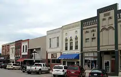 Harlan Courthouse Square Commercial District |
September 23, 1994 (#94001099) |
Market, 6th, 7th, and Court Sts., around Courthouse Sq. 41°39′30″N 95°19′04″W |
Harlan | |
| 5 | Irwin Consolidated School | 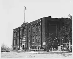 Irwin Consolidated School |
October 24, 2002 (#02001246) |
North St. 41°47′41″N 95°12′21″W |
Irwin | |
| 6 | Chris Larsen House | October 3, 1991 (#91001456) |
4215 Main St. 41°35′33″N 95°03′34″W |
Elk Horn | ||
| 7 | Pleasant View Stock Farm Historic District | July 3, 2019 (#100004112) |
1933-1935 Road M36 41°47′15″N 95°16′02″W |
Irwin vicinity | ||
| 8 | Chris Poldberg Farmstead | October 3, 1991 (#91001459) |
0.5 miles south of Iowa Highway 44 on Wolf Creek 41°37′28″N 95°07′54″W |
Jacksonville | ||
| 9 | George Rewerts House | 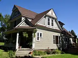 George Rewerts House |
October 3, 1991 (#91001450) |
306 8th Ave. 41°49′45″N 95°20′33″W |
Defiance | |
| 10 | Saint Boniface Catholic Church District | .jpg.webp) Saint Boniface Catholic Church District |
October 3, 1991 (#91001449) |
Three blocks north of County Road F32 41°43′17″N 95°23′44″W |
Westphalia | |
| 11 | St. Paul's Episcopal Church | .jpg.webp) St. Paul's Episcopal Church |
September 1, 1978 (#78001259) |
712 Farnham St. 41°39′16″N 95°19′04″W |
Harlan | |
| 12 | Shelby Consolidated School | February 5, 2014 (#13001139) |
304 Western Ave. 41°31′00″N 95°27′31″W |
Shelby | ||
| 13 | Shelby County Courthouse | 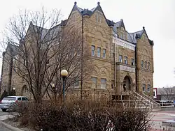 Shelby County Courthouse |
November 14, 1978 (#78001258) |
7th and Court Sts. 41°39′23″N 95°19′09″W |
Harlan |
Former listings
| [3] | Name on the Register | Image | Date listed | Date removed | Location | City or town | Summary |
|---|---|---|---|---|---|---|---|
| 1 | J.C. Heese Lumber Shed | 1991 (#91001454) | November 12, 1997 | Railway St., E side |
Earling |
See also
| Wikimedia Commons has media related to National Register of Historic Places in Shelby County, Iowa. |
References
- The latitude and longitude information provided in this table was derived originally from the National Register Information System, which has been found to be fairly accurate for about 99% of listings. Some locations in this table may have been corrected to current GPS standards.
- "National Register of Historic Places: Weekly List Actions". National Park Service, United States Department of the Interior. Retrieved on February 5, 2021.
- Numbers represent an alphabetical ordering by significant words. Various colorings, defined here, differentiate National Historic Landmarks and historic districts from other NRHP buildings, structures, sites or objects.
- "National Register Information System". National Register of Historic Places. National Park Service. April 24, 2008.
- The eight-digit number below each date is the number assigned to each location in the National Register Information System database, which can be viewed by clicking the number.
| Topics | |
|---|---|
| Lists by state |
|
| Lists by insular areas | |
| Lists by associated state | |
| Other areas | |
| Related | |
| |

Municipalities and communities of Shelby County, Iowa, United States | ||
|---|---|---|
| Cities | Map of Iowa highlighting Shelby County | |
| CDPs | ||
| Unincorporated communities | ||
| Footnotes | ‡This populated place also has portions in an adjacent county or counties | |
| ||
This article is issued from Wikipedia. The text is licensed under Creative Commons - Attribution - Sharealike. Additional terms may apply for the media files.