National Register of Historic Places listings in Crawford County, Iowa
This is a list of the National Register of Historic Places listings in Crawford County, Iowa.
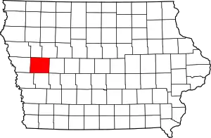
Location of Crawford County in Iowa
This is intended to be a complete list of the properties and districts on the National Register of Historic Places in Crawford County, Iowa, United States. Latitude and longitude coordinates are provided for many National Register properties and districts; these locations may be seen together in a map.[1]
There are 12 properties listed on the National Register in the county.
- This National Park Service list is complete through NPS recent listings posted January 29, 2021.[2]
| [3] | Name on the Register[4] | Image | Date listed[5] | Location | City or town | Description |
|---|---|---|---|---|---|---|
| 1 | Buck Grove Bridge | June 25, 1998 (#98000797) |
Buck Creek Ave. over Buck Creek 41°54′50″N 95°22′49″W |
Buck Grove | ||
| 2 | John T. and Marietta (Greek) Carey House | 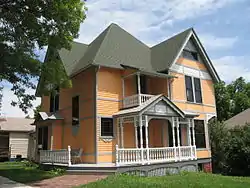 John T. and Marietta (Greek) Carey House |
April 11, 2005 (#05000276) |
1502 1st Ave., N. 42°01′03″N 95°21′06″W |
Denison | Designed by architect George Franklin Barber |
| 3 | Clarence D. Chamberlin House | 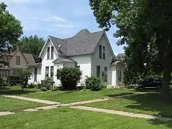 Clarence D. Chamberlin House |
April 28, 1977 (#77000505) |
1434 2nd Ave., S. 42°00′53″N 95°21′07″W |
Denison | |
| 4 | Crawford County Courthouse | 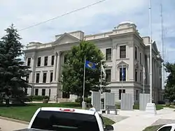 Crawford County Courthouse |
July 2, 1981 (#81000232) |
Broadway between Ave. B and Ave. C 42°01′01″N 95°21′24″W |
Denison | |
| 5 | Dow House | 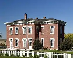 Dow House |
June 14, 1972 (#72000471) |
Prince St. at the southern city limit 41°55′30″N 95°29′50″W |
Dow City | |
| 6 | Z.T. Dunham Pioneer Stock Farm | August 2, 1993 (#93000652) |
Iowa Highway 37, 1 mile northwest of Dunlap 41°52′03″N 95°37′09″W |
Dunlap | ||
| 7 | Klondike Hotel | October 3, 1996 (#96001060) |
332 3rd St. 41°53′26″N 95°14′03″W |
Manilla | ||
| 8 | William A. McHenry House | 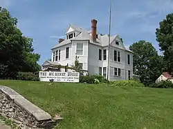 William A. McHenry House |
November 7, 1976 (#76000755) |
1428 1st Ave., N. 42°01′05″N 95°21′07″W |
Denison | |
| 9 | Nishnabotna River Bridge | 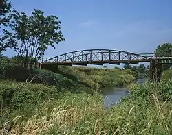 Nishnabotna River Bridge |
March 12, 1999 (#99000309) |
310th St. between X and Y Aves. 41°52′00″N 95°16′00″W |
Manilla | |
| 10 | Nishnabotna River Bridge |  Nishnabotna River Bridge |
June 25, 1998 (#98000801) |
T Ave. over the Nishnabotna River 41°56′08″N 95°13′08″W |
Manilla | |
| 11 | Park Motel | 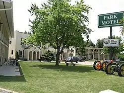 Park Motel |
June 2, 2000 (#00000565) |
803 4th Ave. S. 42°00′43″N 95°21′45″W |
Denison | |
| 12 | Yellow Smoke Park Bridge | June 25, 1998 (#98000800) |
Pedestrian path over an unnamed stream 42°01′36″N 95°19′05″W |
Denison |
Former listings
| [3] | Name on the Register | Image | Date listed | Date removed | Location | Summary |
|---|---|---|---|---|---|---|
| 1 | Beaver Creek Bridge | June 25, 1998 (#98000799) | July 31, 2020 | 180th St. between B and C Aves. over Beaver Creek 42°11′42″N 95°31′02″W |
||
| 2 | East Soldier River Bridge | June 25, 1998 (#98000798) | July 31, 2020 | 120th St. over the East Soldier River 42°03′28″N 95°38′01″W |
See also
| Wikimedia Commons has media related to National Register of Historic Places in Crawford County, Iowa. |
References
- The latitude and longitude information provided in this table was derived originally from the National Register Information System, which has been found to be fairly accurate for about 99% of listings. Some locations in this table may have been corrected to current GPS standards.
- "National Register of Historic Places: Weekly List Actions". National Park Service, United States Department of the Interior. Retrieved on January 29, 2021.
- Numbers represent an alphabetical ordering by significant words. Various colorings, defined here, differentiate National Historic Landmarks and historic districts from other NRHP buildings, structures, sites or objects.
- "National Register Information System". National Register of Historic Places. National Park Service. April 24, 2008.
- The eight-digit number below each date is the number assigned to each location in the National Register Information System database, which can be viewed by clicking the number.
| Topics | |
|---|---|
| Lists by state |
|
| Lists by insular areas | |
| Lists by associated state | |
| Other areas | |
| Related | |
| |

Municipalities and communities of Crawford County, Iowa, United States | ||
|---|---|---|
| Cities | Map of Iowa highlighting Crawford County | |
| Townships | ||
| Unincorporated communities | ||
| Footnotes | ‡This populated place also has portions in an adjacent county or counties | |
| ||
This article is issued from Wikipedia. The text is licensed under Creative Commons - Attribution - Sharealike. Additional terms may apply for the media files.