National Register of Historic Places listings in Fremont County, Iowa
This is intended to be a complete list of the properties and districts on the National Register of Historic Places in Fremont County, Iowa, United States. Latitude and longitude coordinates are provided for many National Register properties and districts; these locations may be seen together in a map.[1]
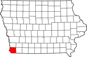
Location of Fremont County in Iowa
There are 9 properties and districts listed on the National Register in the county, including one National Historic Landmark.
- This National Park Service list is complete through NPS recent listings posted February 5, 2021.[2]
| [3] | Name on the Register[4] | Image | Date listed[5] | Location | City or town | Description |
|---|---|---|---|---|---|---|
| 1 | Chautauqua Pavilion | .jpg.webp) Chautauqua Pavilion |
October 22, 1976 (#76000773) |
Iowa Highway 42 40°40′55″N 95°34′09″W |
Riverton | |
| 2 | Fremont County Courthouse | 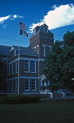 Fremont County Courthouse |
July 2, 1981 (#81000238) |
Clay St. 40°44′45″N 95°38′37″W |
Sidney | |
| 3 | Hamburg Public Library | 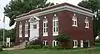 Hamburg Public Library |
May 23, 1983 (#83000359) |
1301 Main St. 40°36′23″N 95°39′27″W |
Hamburg | |
| 4 | Hunter School | 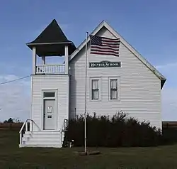 Hunter School |
January 9, 2007 (#06001220) |
Junction of U.S. Route 275 and 120th St. 40°52′24″N 95°40′16″W |
Tabor | |
| 5 | Jason and Elizabeth Baylor Rector House | 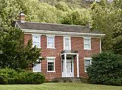 Jason and Elizabeth Baylor Rector House |
February 4, 2002 (#01001542) |
2174 Bluff Rd. 40°43′58″N 95°42′35″W |
Thurman | |
| 6 | St. Patrick Church | .jpg.webp) St. Patrick Church |
July 7, 1983 (#83000360) |
3rd St. 40°52′51″N 95°25′32″W |
Imogene | |
| 7 | Tabor Antislavery Historic District | October 31, 2007 (#07001117) |
Park, Center, Orange, and Elm Sts. 40°53′57″N 95°40′29″W |
Tabor | ||
| 8 | Tabor Congregational Church | 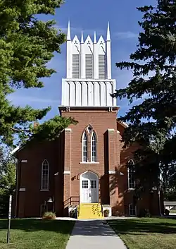 Tabor Congregational Church |
October 6, 2011 (#11000720) |
403 Elm St. 40°54′01″N 95°40′25″W |
Tabor | |
| 9 | Todd House | 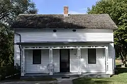 Todd House |
August 15, 1975 (#75000689) |
Park St. 40°53′58″N 95°40′35″W |
Tabor |
See also
| Wikimedia Commons has media related to National Register of Historic Places in Fremont County, Iowa. |
References
- The latitude and longitude information provided in this table was derived originally from the National Register Information System, which has been found to be fairly accurate for about 99% of listings. Some locations in this table may have been corrected to current GPS standards.
- "National Register of Historic Places: Weekly List Actions". National Park Service, United States Department of the Interior. Retrieved on February 5, 2021.
- Numbers represent an alphabetical ordering by significant words. Various colorings, defined here, differentiate National Historic Landmarks and historic districts from other NRHP buildings, structures, sites or objects.
- "National Register Information System". National Register of Historic Places. National Park Service. April 24, 2008.
- The eight-digit number below each date is the number assigned to each location in the National Register Information System database, which can be viewed by clicking the number.
| Topics | |
|---|---|
| Lists by state |
|
| Lists by insular areas | |
| Lists by associated state | |
| Other areas | |
| Related | |
| |

Municipalities and communities of Fremont County, Iowa, United States | ||
|---|---|---|
| Cities | Map of Iowa highlighting Fremont County | |
| Townships | ||
| CDPs | ||
| Other unincorporated community | ||
| Footnotes | ‡This populated place also has portions in an adjacent county or counties | |
| ||
This article is issued from Wikipedia. The text is licensed under Creative Commons - Attribution - Sharealike. Additional terms may apply for the media files.