Auberville-la-Manuel
Auberville-la-Manuel is a commune in the Seine-Maritime department in the Normandy region in northern France.
Auberville-la-Manuel | |
|---|---|
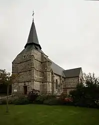 The church in Auberville-la-Manuel | |
.svg.png.webp) Coat of arms | |
Location of Auberville-la-Manuel 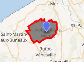
| |
 Auberville-la-Manuel  Auberville-la-Manuel | |
| Coordinates: 49°49′43″N 0°35′22″E | |
| Country | France |
| Region | Normandy |
| Department | Seine-Maritime |
| Arrondissement | Dieppe |
| Canton | Saint-Valery-en-Caux |
| Intercommunality | CC Côte Albâtre |
| Government | |
| • Mayor (2014-2020) | Jean-Marie Georges |
| Area 1 | 3.02 km2 (1.17 sq mi) |
| Population (2017-01-01)[1] | 130 |
| • Density | 43/km2 (110/sq mi) |
| Time zone | UTC+01:00 (CET) |
| • Summer (DST) | UTC+02:00 (CEST) |
| INSEE/Postal code | 76032 /76450 |
| Elevation | 23–85 m (75–279 ft) (avg. 80 m or 260 ft) |
| 1 French Land Register data, which excludes lakes, ponds, glaciers > 1 km2 (0.386 sq mi or 247 acres) and river estuaries. | |
Geography
A small farming village in the Pays de Caux, situated some 25 miles (40 km) west of Dieppe on the D68 road.
Heraldry
Arms of Auberville-la-Manuel |
The arms of Auberville-la-Manuel are blazoned : Gules, a cross argent between 1: the local castle door flanked by 2 towers; 2: a bouquet of 3 wheat stalks; 3: 3 flax flowers slipped and leaved and 4: a cow Or. |
Population
| Year | 1962 | 1968 | 1975 | 1982 | 1990 | 1999 | 2006 | 2015 |
|---|---|---|---|---|---|---|---|---|
| Population | 174 | 207 | 166 | 145 | 127 | 103 | 118 | 124 |
| From the year 1962 on: No double counting—residents of multiple communes (e.g. students and military personnel) are counted only once. | ||||||||
Places of interest
- The church, dating from the thirteenth century.
- The chateau, dating from the fifteenth century.
References
- "Populations légales 2017". INSEE. Retrieved 6 January 2020.
| Wikimedia Commons has media related to Auberville-la-Manuel. |
| Authority control |
|---|
This article is issued from Wikipedia. The text is licensed under Creative Commons - Attribution - Sharealike. Additional terms may apply for the media files.