Bosc-le-Hard
Bosc-Le-Hard is a commune in the Seine-Maritime department in the Normandy region in northern France.
Bosc-Le-Hard | |
|---|---|
 Coat of arms | |
Location of Bosc-Le-Hard 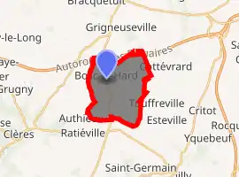
| |
 Bosc-Le-Hard  Bosc-Le-Hard | |
| Coordinates: 49°37′38″N 1°10′37″E | |
| Country | France |
| Region | Normandy |
| Department | Seine-Maritime |
| Arrondissement | Rouen |
| Canton | Neufchâtel-en-Bray |
| Intercommunality | Inter-Caux-Vexin |
| Government | |
| • Mayor (2020–2026) | Philippe Vincent |
| Area 1 | 10.37 km2 (4.00 sq mi) |
| Population (2017-01-01)[1] | 1,462 |
| • Density | 140/km2 (370/sq mi) |
| Time zone | UTC+01:00 (CET) |
| • Summer (DST) | UTC+02:00 (CEST) |
| INSEE/Postal code | 76125 /76850 |
| Elevation | 128–176 m (420–577 ft) (avg. 170 m or 560 ft) |
| 1 French Land Register data, which excludes lakes, ponds, glaciers > 1 km2 (0.386 sq mi or 247 acres) and river estuaries. | |
Geography
A village of farming and light industry, situated in the Pays de Bray, some 26 miles (42 km) south of Dieppe, at the junction of the D25 and the D151 roads. The A29 autoroute forms the northern border of the commune.
Heraldry
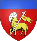
Arms of Bosc-Le-Hard |
The arms of Bosc-Le-Hard are blazoned : Gules, a pascal lamb Or haloed argent, holding a long cross from which flies a banner Or charged a cross gules, and a chief azure. |
Population
| Year | 1962 | 1968 | 1975 | 1982 | 1990 | 1999 | 2006 |
|---|---|---|---|---|---|---|---|
| Population | 825 | 876 | 1224 | 1178 | 1271 | 1411 | 1469 |
| From the year 1962 on: No double counting—residents of multiple communes (e.g. students and military personnel) are counted only once. | |||||||
Places of interest
- The church of St.John, dating from the eighteenth century.
- The modern church of St. Eloi.
- The chateau du Réel.
- The chapel at Augeville.
Twin towns
 Goldenstedt, Germany, since 1989
References
- "Populations légales 2017". INSEE. Retrieved 6 January 2020.
External links
| Wikimedia Commons has media related to Bosc-le-Hard. |
- Official commune website (in French)
| Authority control |
|---|
This article is issued from Wikipedia. The text is licensed under Creative Commons - Attribution - Sharealike. Additional terms may apply for the media files.