Notre-Dame-de-Bliquetuit
Notre-Dame-de-Bliquetuit is a commune in the Seine-Maritime department in the Normandy region in northern France.
Notre-Dame-de-Bliquetuit | |
|---|---|
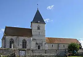 The church in Notre-Dame-de-Bliquetuit | |
Location of Notre-Dame-de-Bliquetuit 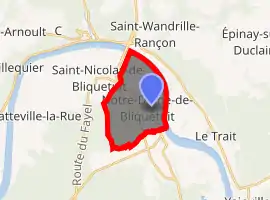
| |
 Notre-Dame-de-Bliquetuit  Notre-Dame-de-Bliquetuit | |
| Coordinates: 49°29′44″N 0°45′54″E | |
| Country | France |
| Region | Normandy |
| Department | Seine-Maritime |
| Arrondissement | Rouen |
| Canton | Port-Jérôme-sur-Seine |
| Intercommunality | CA Caux vallée de Seine |
| Government | |
| • Mayor (2020–2026) | Fabienne Duparc[1] |
| Area 1 | 9.78 km2 (3.78 sq mi) |
| Population (2017-01-01)[2] | 754 |
| • Density | 77/km2 (200/sq mi) |
| Time zone | UTC+01:00 (CET) |
| • Summer (DST) | UTC+02:00 (CEST) |
| INSEE/Postal code | 76473 /76940 |
| Elevation | 1–53 m (3.3–173.9 ft) (avg. 11 m or 36 ft) |
| 1 French Land Register data, which excludes lakes, ponds, glaciers > 1 km2 (0.386 sq mi or 247 acres) and river estuaries. | |
Geography
A farming village situated in the Pays de Caux by the banks of the river Seine, some 16 miles (26 km) west of Rouen at the junction of the D490 and the D65 roads. The nearby Brotonne bridge was, until the late 20th century, the only bridge over the Seine downstream of Rouen.
Population
| Year | Pop. | ±% p.a. |
|---|---|---|
| 1968 | 393 | — |
| 1975 | 413 | +0.71% |
| 1982 | 469 | +1.83% |
| 1990 | 504 | +0.90% |
| 1999 | 559 | +1.16% |
| 2007 | 641 | +1.73% |
| 2012 | 733 | +2.72% |
| 2017 | 754 | +0.57% |
| Source: INSEE[3] | ||
Places of interest
- The church of Notre-Dame, dating from the eleventh century.
- The Notre-Dame manorhouse.
- A sixteenth century dovecote.
- The Maison du Parc, an ancient farmhouse.
References
- "Répertoire national des élus: les maires". data.gouv.fr, Plateforme ouverte des données publiques françaises (in French). 2 December 2020. Retrieved 7 December 2020.
- "Populations légales 2017". INSEE. Retrieved 6 January 2020.
- Population en historique depuis 1968, INSEE
| Wikimedia Commons has media related to Notre-Dame-de-Bliquetuit. |
| Authority control |
|---|
This article is issued from Wikipedia. The text is licensed under Creative Commons - Attribution - Sharealike. Additional terms may apply for the media files.